Fitzpatrick, Alabama
| Fitzpatrick, Alabama | |
|---|---|
| Census-designated place (CDP) | |
 Fitzpatrick, Alabama | |
| Coordinates: 32°13′00″N 85°53′20″W / 32.21667°N 85.88889°WCoordinates: 32°13′00″N 85°53′20″W / 32.21667°N 85.88889°W | |
| Country | United States |
| State | Alabama |
| County | Bullock |
| Elevation | 262 ft (80 m) |
| Population (2010)[1] | |
| • Total | 83 |
| Time zone | Central (CST) (UTC-6) |
| • Summer (DST) | CDT (UTC-5) |
| ZIP code | 36029 |
| Area code(s) | 334 |
| GNIS feature ID | 157952[2] |
Fitzpatrick is an unincorporated community and census-designated place in Bullock County, Alabama, United States. As of the 2010 census, its population was 83.[1] The community is served by Alabama State Route 110.
Demographics
| Historical population | |||
|---|---|---|---|
| Census | Pop. | %± | |
| 1890 | 357 | — | |
| 1900 | 447 | 25.2% | |
| 1910 | 398 | −11.0% | |
| 1920 | 339 | −14.8% | |
| 2010 | 83 | — | |
| U.S. Decennial Census[3] | |||
References
- 1 2 "American FactFinder". United States Census Bureau. Archived from the original on September 11, 2013. Retrieved 2011-05-14.
- ↑ U.S. Geological Survey Geographic Names Information System: Fitzpatrick, Alabama
- ↑ "U.S. Decennial Census". Census.gov. Archived from the original on May 11, 2015. Retrieved June 6, 2013.
Municipalities and communities of Bullock County, Alabama, United States | ||
|---|---|---|
| Cities | 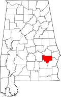 | |
| Towns | ||
| CDP | ||
| Unincorporated communities | ||
| Ghost towns | ||
This article is issued from Wikipedia - version of the 7/21/2016. The text is available under the Creative Commons Attribution/Share Alike but additional terms may apply for the media files.