Firstview, Colorado
| Firstview, Colorado | |
|---|---|
| Unincorporated community | |
 Firstview, Colorado  Firstview, Colorado | |
| Coordinates: 38°48′57″N 102°32′23″W / 38.81583°N 102.53972°WCoordinates: 38°48′57″N 102°32′23″W / 38.81583°N 102.53972°W | |
| Country | United States |
| State | Colorado |
| County | Cheyenne |
| Elevation | 4,577 ft (1,395 m) |
| Time zone | Mountain (MST) (UTC-7) |
| • Summer (DST) | MDT (UTC-6) |
| ZIP code | 80810[1] |
| Area code(s) | 719 |
| GNIS feature ID | 1947719[2] |
Firstview is an unincorporated community in Cheyenne County, Colorado, United States. The community is located on U.S. Highway 40; the nearest city is Cheyenne Wells. The geographic coordinates of Firstview are roughly the antipodes of the coordinates of Île Saint-Paul, a French island in the Indian Ocean. This island is one of only three land areas which have antipodes within the United States.
The town was laid out in 1911. It was named for the spot where travelers got their first glimpse of Pikes Peak, 110 miles (180 km) in the distance.[3]
References
- ↑ "ZIP Code Lookup". United States Postal Service. Archived from the original (JavaScript/HTML) on November 23, 2010. Retrieved December 1, 2008.
- ↑ "US Board on Geographic Names". United States Geological Survey. 2007-10-25. Retrieved 2008-01-31.
- ↑ Gallant, Frank K. (May 17, 2012). A Place Called Peculiar: Stories About Unusual American Place-Names. Courier Dover Publications. p. 37. Retrieved 2013-04-19.
Municipalities and communities of Cheyenne County, Colorado, United States | ||
|---|---|---|
| Towns | 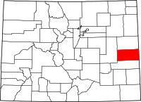 | |
| Unincorporated communities | ||
This article is issued from Wikipedia - version of the 11/5/2016. The text is available under the Creative Commons Attribution/Share Alike but additional terms may apply for the media files.