Fingal Head, New South Wales

Fingal Head and the small off-shore Island (Cook Island) were first sighted by James Cook about 17:00 on 16 May 1770 (log date and time). The area and small town is often just called Fingal. It is located on the Far North Coast of New South Wales in Tweed Shire, about 5 km south of the New South Wales and Queensland border, and south of the Gold Coast. At the time of the 2006 census, Fingal Head had a population of 575 people.[1]
Geography

The Tweed River, (discovered by John Oxley in October 1823) on the north coast of New South Wales runs northwards close to the coast for about 6 km before reaching its mouth just south of present-day Point Danger. A spit about 500–800 metres wide called "Letitia Spit" (named after the first ship to enter the river in July 1840) runs south for 2 km to Fingal Head.
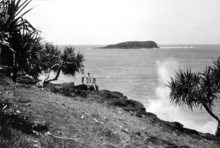
The headland itself was made from a lava flow from the now extinct Tweed Volcano. The rock composition in the area is mainly basalt or andesite. There are walking tracks all over this area. About 500 metres offshore from the headland is Cook Island, a rocky uninhabited island first charted by James Cook in 1770. The stretch of water to the island is called the "Giants Causeway", named after the famous Giants Causeway between Northern Ireland and Western Scotland. Cook Island was made a marine reserve in 1998 and as such fishing is prohibited in the waters nearby.
History
There has been controversy over the naming of Fingal Head by James Cook in May 1770 for many years. Strong evidence suggests that Fingal Head was, in fact, the point James Cook named Point Danger.
In 1823, John Oxley took shelter from Southerly winds, while sailing North from Port Macquarie. "At 3 made sail intending to anchor to the South of Point Danger. At 5 passed close to a Bold Headland about 3 Miles North of Pt.D. (Point Danger) On the South Side of this headland we had the satisfaction to discover a considerable river with an apparent clear entrance." (Tweed River)
John Uniack and later Oxley went onto the island, where they found some sea turtles and called the island "Turtle Island". In 1828 Henry John Rous (Captain of HMS Rainbow) surveyed Oxley's Tweed River, the name used today. A chart published in 1831 by the Master of the "Rainbow" showing the island as "Cook's Isle" and the river named the "Clarance River" - the unnamed headland, North of the river was also named Point Danger. However the off-shore reefs East of the Island were not marked. Fingal Head would be named as such by Surveyor Robert Dixon who mapped the coastal districts between Brisbane Town and the Brunswick River in the winter months of 1840. It first appears on a map published By Dixon in Sydney in 1842. Dixon's party was also assisted at that time by the master and crew of the schooner Letitia, which they found had entered the Tweed. Hence the naming of Letitia Point. There is also every suggestion that Dixon made reference to the Giant's Causeway. It is highly probable that "Fingal Head" was named after Fingal's Cave on the island of Staffa in the Inner Hebrides of Scotland because of the similarity in appearance due to naturally formed Columnar Basalt outcrops which extend above the ocean surface.[2]
The local aboriginal people were the Minjungbal, but white settlement significantly impacted the population in the late 19th to early 20th century.,[3][4] In 1933, the last female full-blood Aborigine on the Tweed was laid to rest in Fingal's Aboriginal cemetery following a service conducted at the mission church.[2]
Fingal Head Post Office opened on 15 March 1912, uprated from a telegraph office opened in October 1911.[5]
Demographics
In the 2011 Census the population of Fingal Head is 544, 48% female and 52% male.
The median/average age of the Fingal Head population is 42 years of age, 5 years above the Australian average.
77% of people living in Fingal Head were born in Australia. The other top responses for country of birth were England 3.1%, New Zealand 2.8%, Hong Kong 0.6%, Germany 0.6%, Czech Republic 0.6%.
88.8% of people speak English as their first language 0.6% Bandjalang, 0.6% Italian, 0.6% Gumbaynggir, 0.6% Czech.
Lighthouse

A provisional light station was established on the head in 1872 and in 1878 a proper lighthouse, built as a sandstone construction in a round design, was inaugurated. It was part of a series of five such lighthouses established between 1878 and 1880. The tower only stands 7 metres high, but that suffices since the headland itself adds additional height. Thus the focal plane of the lightsource is situated at 24 m above sea level. In 1920 the lightsource was changed from kerosene to acetylene and became automated. It was electrified in 1980. The light characteristic is a single flash every five seconds. Depending on the bearing, red light is shown in the east sector while the other sectors show white.[6][7]
Surfing
Since 1996 Fingal has hosted an annual surfing competition for indigenous surfers. The first year attracted 90 surfers from across Australia. In 1999, SBS television commissioned a documentary called Surfing the Healing Wave about that competition, as part of an Unfinished Business - Reconciling the Nation series. It won Best Australian Documentary at the 2000 Real Life on Film Festival.
Fingal is not particularly noted as a surf spot as such. The headland does not form a point break on either side, so it is just beach breaks that occur there, but the southern side is one of the few places near the Gold Coast with any protection from northerly winds.[8][9]
References
- ↑ Australian Bureau of Statistics (25 October 2007). "Fingal Head (State Suburb)". 2006 Census QuickStats. Retrieved 20 September 2009.
- 1 2 "Fingal remains a quaint village". Tweed Daily News. Retrieved 2016-05-11.
- ↑ James Cook's hand-written manuscript dated 16 may 1770 held at the National Library
- ↑ John Oxley's hand-written note book, dated Fri.31 Oct [1823] (Archives Office of NSW location 2/8093)
- ↑ Premier Postal History. "Post Office List". Premier Postal Auctions. Retrieved 2011-05-26.
- ↑ "The Fingal Head lighthouse". Lighthouses of New South Wales. Lighthouses of Australia Inc.
- ↑ Rowlett, Russ. "Lighthouses of Australia: New South Wales". The Lighthouse Directory. University of North Carolina at Chapel Hill.
- ↑ Surfing the Healing Wave at the Australian Film Commission
- ↑ Surfing the Healing Wave at Ronin Films
External links
- Fingal Head page at Geoscience Australia
- Fingal Head travel, in The Age newspaper 8 February 2004
- Northern Rivers Geology Blog - Fingal Head