Ferreira do Zêzere
| Ferreira do Zêzere | |||
|---|---|---|---|
| Municipality | |||
| |||
 | |||
| Coordinates: 39°41′N 8°17′W / 39.683°N 8.283°WCoordinates: 39°41′N 8°17′W / 39.683°N 8.283°W | |||
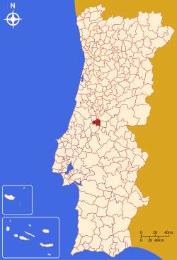
| Country |
| ||
| Region | Centro | ||
| Subregion | Médio Tejo | ||
| Intermunic. comm. | Médio Tejo | ||
| District | Santarém | ||
| Parishes | 7 | ||
| Government | |||
| • President | Jacinto Lopes (PSD) | ||
| Area | |||
| • Total | 190.38 km2 (73.51 sq mi) | ||
| Population (2011) | |||
| • Total | 8,619 | ||
| • Density | 45/km2 (120/sq mi) | ||
| Time zone | WET/WEST (UTC+0/+1) | ||
| Website | http://www.cm-ferreiradozezere.pt | ||


Ferreira do Zêzere (Portuguese pronunciation: [fɨˈʁɐjɾɐ ðu ˈzezɨɾ(ɨ)]) is a municipality in Santarém District in Portugal. The population in 2011 was 8,619,[1] in an area of 190.38 km².[2] The municipal holiday is June 13.
Parishes
Administratively, the municipality is divided into 7 civil parishes (freguesias):[3]
- Águas Belas
- Areias e Pias
- Beco
- Chãos
- Ferreira do Zêzere
- Igreja Nova do Sobral
- Nossa Senhora do Pranto
History
This old village, founded by Pedro Ferreira and his wife in the 13th century is actually one of the most touristic villages in the district of Santarém. In the surroundings of Ferreira do Zêzere there is the medieval Vila de Dornes with an excellent view over the Zêzere River and a classified Templar Tower.
References
- ↑ Instituto Nacional de Estatística
- ↑ Direção-Geral do Território
- ↑ Diário da República. "Law nr. 11-A/2013, page 552 49" (pdf) (in Portuguese). Retrieved 22 July 2014.
External links
This article is issued from Wikipedia - version of the 10/24/2016. The text is available under the Creative Commons Attribution/Share Alike but additional terms may apply for the media files.