Farafangana
| Farafangana | |
|---|---|
| City | |
|
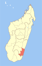
Location of Farafangana | |
| Country | Madagascar |
| Region | Atsimo-Atsinanana |
| Elevation | 1 m (3 ft) |
| Population | |
| • Total | 24,252 |
| • Density | 155/km2 (400/sq mi) |
| Climate | Af |
| Website | http://www.farafangana.com/ |

Farafangana is a city (commune urbaine) on the south-east coast of Madagascar and capital of the Atsimo-Atsinanana region. The population essentially consists of three ethnic groups: the Antefasy, Rabakara and Zafisoro.
Location
Farafangana is located approximately 400 kilometres south of the capital Antananarivo. It is at the southern end of the Canal des Pangalanes,[1] with the mouth of the Manampatrana River located on the north side of the town. It is 106km south of Manakara, about 2.5 hours travel time away.[2]
Settlements located to the north include Lokandambo, Manambotra, Ambahikarabo and Amboahangimamy, with Ambalolo to the west. To the south are Antananabo, Manambotra Atsimo and Marosondry.[3]
Economy
There is an airport in Farafangana (Farafangana Airport). One of the main crops in the region is pepper.[4]
Tourism
The Manombo Reserve is located at 25 km to Farafangana.[5]
See also
References
- ↑ Madagascar & Comoros, p. 232 (Lonely Planet, 2008)
- ↑ Madagascar 2014-2015 Petit Futé, p. 249 (2013)
- ↑ http://www.fallingrain.com/world/MA/2/Farafangana.html
- ↑ (French) www.commerce.gov.mg
- ↑ travalmadagascar.org
Coordinates: 22°49′S 47°49′E / 22.817°S 47.817°E