Euclid Avenue Historic District (Cleveland, Ohio)
|
Euclid Avenue Historic District and Boundary Increase | |
|
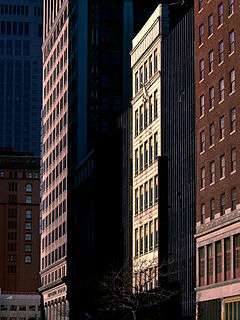
High-rise facades on the north side of Euclid Avenue, just east of East 9th Street | |
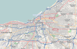   | |
| Location | Roughly bounded by Public Square, Euclid Ave. to E. 17th St., and E. 21st St. (original); 205 St. Clair Ave., 1370 Ontario St., and 1796-1808 E. 13th St. (increase), Cleveland, Ohio |
|---|---|
| Coordinates | 41°30′2″N 81°41′12″W / 41.50056°N 81.68667°WCoordinates: 41°30′2″N 81°41′12″W / 41.50056°N 81.68667°W |
| Area | 125 acres (51 ha) (original); 4 acres (1.6 ha) (increase) |
| Architect | Knox and Elliot; Murgatroyd, Robert, and Odgen |
| Architectural style | Late 19th and 20th Century Revivals, Late 19th and Early 20th Century American Movements |
| NRHP Reference # | 02000702 (original); 07000524 (increase)[1] |
| Added to NRHP | June 28, 2002 (original); May 29, 2007 (increase) |
The Euclid Avenue Historic District is a historic district in downtown Cleveland, Ohio, United States. Established and listed on the National Register of Historic Places in 2002, it comprises 125 acres (51 ha) along Euclid Avenue and parallel streets from Public Square to East 21st Street. In 2007, another 4 acres (1.6 ha) was added to the district; the boundary increase included buildings exclusively located along parallel streets.[1]
References
- 1 2 National Park Service (2009-03-13). "National Register Information System". National Register of Historic Places. National Park Service.
This article is issued from Wikipedia - version of the 11/27/2016. The text is available under the Creative Commons Attribution/Share Alike but additional terms may apply for the media files.