Esperadinha Airport
| Esperadinha Airport | |||||||||||
|---|---|---|---|---|---|---|---|---|---|---|---|
 The airport in 1994 | |||||||||||
| IATA: BVR – ICAO: GVBR | |||||||||||
| Summary | |||||||||||
| Airport type | Public | ||||||||||
| Serves | Esperadinha | ||||||||||
| Location |
| ||||||||||
| Elevation AMSL | 10 ft / 3 m | ||||||||||
| Coordinates | 14°51′51.6″N 024°44′45.5″W / 14.864333°N 24.745972°WCoordinates: 14°51′51.6″N 024°44′45.5″W / 14.864333°N 24.745972°W | ||||||||||
| Map | |||||||||||
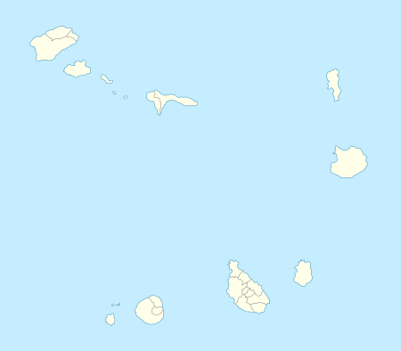 GVBR Location of Esperadinha Airport in Cape Verde | |||||||||||
| Runways | |||||||||||
| |||||||||||
Esperadinha Airport (IATA: BVR, ICAO: GVBR) was a public use airport located near the hamlet of Esperadinha in the shores of Fajã de Água in, Brava, Cape Verde. It opened in 1992 and operated until 2004, when it was closed due to persistent dangerous high winds. Its airport service would again be on the island of Fogo at São Filipe Airport, along with Santo Antão it is an island without having its own airport
See also
References
- ↑ Airport record for Esperadinha Airport at Landings.com. Retrieved 2013-08-25
- ↑ Google (2013-08-25). "location of Esperadinha Airport" (Map). Google Maps. Google. Retrieved 2013-08-25.
External links
- Airport record for Esperadinha Airport at Landings.com
This article is issued from Wikipedia - version of the 12/1/2016. The text is available under the Creative Commons Attribution/Share Alike but additional terms may apply for the media files.