Enghave Brygge

Enghave Brygge (English: Enghave Quay) is a waterfront area in the Souterhn Docklands of Copenhagen, Denmark. It is located between Teglholmen to the south and Kalvebod Brygge to the north. Currently an abandoned industrial site, a plan for its redevelopment was adopted in July 2013. The most prominent landmark in the area is the H. C. Ørsted Power Station.
Redevelopment
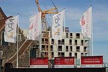
The land is owned by NPV A/S, JM Danmark samt By & Havn. The plan for the area has been created by Juul Frost Arkitekter, Gröning Arkitekter and Danielsen Architecture in collaboration with the City. The area will comprise 2,400 apartments and about 37.800 square metres of commercial and retail space. A central element in the plan is the creation of a 700 metres long canal, Enghave Canal, which will be a modern equivavalent to Christianshavn Canal on the other side of the harbor. The buildings along the water will be located on 11 individual "islands". A greenspace will mark the transition to H. C. Ørsted Power Station.[1]
Transport
Enghave Brygge will be a station on the planned South Harbour Line of the Copenhagen Metro.[2] Bridges will connect Enghave Brygge to Teglholmen to the south and across the harbor to the southern part of Islands Brygge.
See also
References
- ↑ "Grønt lys til Enghave Brygge". Building Supply. Retrieved 2013-10-01.
- ↑ "Metrolinje på vej til Sydhavnen" (in Danish). Ingeniøren. Retrieved 2013-09-01.
External links
Coordinates: 55°39′20″N 12°33′37″E / 55.6555°N 12.5603°E