Emerson, Nebraska
| Emerson, Nebraska | |
|---|---|
| Village | |
|
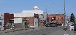
Downtown Emerson: west side of Main Street | |
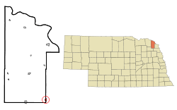 Location of Emerson within Dixon County and Nebraska | |
| Coordinates: 42°16′44″N 96°43′33″W / 42.27889°N 96.72583°WCoordinates: 42°16′44″N 96°43′33″W / 42.27889°N 96.72583°W | |
| Country | United States |
| State | Nebraska |
| Counties | Dixon, Dakota, Thurston |
| Area[1] | |
| • Total | 0.47 sq mi (1.22 km2) |
| • Land | 0.47 sq mi (1.22 km2) |
| • Water | 0 sq mi (0 km2) |
| Elevation | 1,493 ft (455 m) |
| Population (2010)[2] | |
| • Total | 840 |
| • Estimate (2012[3]) | 830 |
| • Density | 1,787.2/sq mi (690.0/km2) |
| Time zone | Central (CST) (UTC-6) |
| • Summer (DST) | CDT (UTC-5) |
| ZIP code | 68733 |
| Area code(s) | 402 |
| FIPS code | 31-15710 |
| GNIS feature ID | 0829108[4] |
| Website | http://emerson-ne.com/ |
Emerson is a village in Dakota, Dixon, and Thurston Counties in the State of Nebraska. The population was 840 at the 2010 census. Emerson is the only community in Nebraska that lies in three counties.[5]
The Dakota and Dixon county portions of Emerson are part of the Sioux City, IA–NE–SD Metropolitan Statistical Area.
History
Emerson was laid out in 1881 at an important rail junction.[6][7] It was named in honor of the poet Ralph Waldo Emerson.[8] Emerson was incorporated as a village in 1888.[9]
Geography
Emerson is located at 42°16.62′N 96°43.55′W / 42.27700°N 96.72583°W (42.278988, -96.725942),[10] in the Central Standard Time zone.
According to the United States Census Bureau, the village has a total area of 0.47 square miles (1.22 km2), all of it land.[1]
Demographics
| Historical population | |||
|---|---|---|---|
| Census | Pop. | %± | |
| 1900 | 617 | — | |
| 1910 | 838 | 35.8% | |
| 1920 | 864 | 3.1% | |
| 1930 | 891 | 3.1% | |
| 1940 | 879 | −1.3% | |
| 1950 | 784 | −10.8% | |
| 1960 | 803 | 2.4% | |
| 1970 | 850 | 5.9% | |
| 1980 | 874 | 2.8% | |
| 1990 | 791 | −9.5% | |
| 2000 | 817 | 3.3% | |
| 2010 | 840 | 2.8% | |
| Est. 2015 | 818 | [11] | −2.6% |
| U.S. Decennial Census[12] 2012 Estimate[13] | |||
2010 census
As of the census[2] of 2010, there were 840 people, 355 households, and 218 families residing in the village. The population density was 1,787.2 inhabitants per square mile (690.0/km2). There were 377 housing units at an average density of 802.1 per square mile (309.7/km2). The racial makeup of the village was 96.0% White, 0.1% African American, 1.8% Native American, 0.1% Asian, 0.4% Pacific Islander, 0.5% from other races, and 1.2% from two or more races. Hispanic or Latino of any race were 5.6% of the population.
There were 355 households of which 30.4% had children under the age of 18 living with them, 44.5% were married couples living together, 12.4% had a female householder with no husband present, 4.5% had a male householder with no wife present, and 38.6% were non-families. 36.1% of all households were made up of individuals and 18.3% had someone living alone who was 65 years of age or older. The average household size was 2.27 and the average family size was 2.89.
The median age in the village was 41.6 years. 24.9% of residents were under the age of 18; 6.8% were between the ages of 18 and 24; 21.4% were from 25 to 44; 25% were from 45 to 64; and 22% were 65 years of age or older. The gender makeup of the village was 46.0% male and 54.0% female.
2000 census
As of the census of 2000, there were 817 people, 320 households, and 209 families residing in the village. The population density was 1,705.3 people per square mile (668.2/km²). There were 358 housing units at an average density of 747.2 per square mile (288.0/km²). The racial makeup of the village was 92.78% White, 0.98% Native American, 0.73% Asian, 5.14% from other races, and 0.37% from two or more races. Hispanic or Latino of any race were 5.51% of the population.
There were 329 households out of which 31.6% had children under the age of 18 living with them, 53.5% were married couples living together, 7.6% had a female householder with no husband present, and 36.2% were non-families. 33.4% of all households were made up of individuals and 19.5% had someone living alone who was 65 years of age or older. The average household size was 2.36 and the average family size was 2.97.
In the village the population was spread out with 26.0% under the age of 18, 7.1% from 18 to 24, 23.9% from 25 to 44, 17.9% from 45 to 64, and 26.2% who were 65 years of age or older. The median age was 40 years. For every 100 females there were 92.7 males. For every 100 females age 18 and over, there were 86.9 males.
As of 2000 the median income for a household in the village was $27,411, and the median income for a family was $37,639. Males had a median income of $26,618 versus $18,833 for females. The per capita income for the village was $13,062. About 8.5% of families and 11.3% of the population were below the poverty line, including 14.7% of those under age 18 and 12.4% of those age 65 or over.
Notable people
- Daniel E. Sheehan, American Roman Catholic archbishop.[14]
References
- 1 2 "US Gazetteer files 2010". United States Census Bureau. Retrieved 2012-06-24.
- 1 2 "American FactFinder". United States Census Bureau. Retrieved 2012-06-24.
- ↑ "Population Estimates". United States Census Bureau. Retrieved 2013-05-29.
- ↑ "US Board on Geographic Names". United States Geological Survey. 2007-10-25. Retrieved 2008-01-31.
- ↑ Alan Boye (1 April 2007). The Complete Roadside Guide to Nebraska. U of Nebraska Press. p. 57. ISBN 0-8032-3378-7.
- ↑ "History". Village of Emerson, NE. Retrieved 7 August 2014.
- ↑ Burr, George L. (1921). History of Hamilton and Clay Counties, Nebraska, Volume 1. S.J. Clarke Publishing Company. p. 106.
- ↑ "Profile for Emerson, Nebraska". ePodunk. Retrieved 7 August 2014.
- ↑ ", Dakota County". Center for Advanced Land Management Information Technologies. University of Nebraska. Retrieved 7 August 2014.
- ↑ "US Gazetteer files: 2010, 2000, and 1990". United States Census Bureau. 2011-02-12. Retrieved 2011-04-23.
- ↑ "Annual Estimates of the Resident Population for Incorporated Places: April 1, 2010 to July 1, 2015". Retrieved July 2, 2016.
- ↑ United States Census Bureau. "Census of Population and Housing". Retrieved October 16, 2013.
- ↑ "Annual Estimates of the Resident Population: April 1, 2010 to July 1, 2012". Retrieved October 16, 2013.
- ↑ "Archbishop Daniel Eugene Sheehan". Catholic-Hierarchy.org. David M. Cheney. Retrieved 23 January 2015.
Municipalities and communities of Dakota County, Nebraska, United States | ||
|---|---|---|
| Cities | ||
| Villages | ||
| Unincorporated communities | ||
| Ghost town | ||
| Footnotes | ‡This populated place also has portions in an adjacent county or counties | |
Municipalities and communities of Dixon County, Nebraska, United States | ||
|---|---|---|
| Cities | ||
| Villages | ||
| Townships | ||
| Indian reservations | ||
| Unincorporated community | ||
| Ghost town | ||
| Footnotes | ‡This populated place also has portions in an adjacent county or counties | |
Municipalities and communities of Thurston County, Nebraska, United States | ||
|---|---|---|
| Villages | ||
| CDP | ||
| Townships | ||
| Indian reservations | ||
| Footnotes | ‡This populated place also has portions in an adjacent county or counties | |