Emerald Island (phantom)

The Emerald Island is a phantom island reported to lie between Australia and Antarctica and south of Macquarie Island. It was first sighted by the British sealing ship Emerald, captained by William Elliot, in December 1821,[1] and the name of the supposed island derives from the name of this ship. It was presumed to be a small (but high and mountainous) island located at 57°30′S 162°12′E / 57.500°S 162.200°E.[1][2]
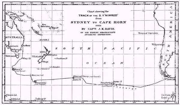
No trace of the island was found by the 1840 United States Exploring Expedition.[3] Although a captain visiting Port Chalmers reported seeing it sometime before 1890,[2] a search by the Nimrod in 1909 turned up nothing.[4] Nevertheless, it appeared on a map as late as 1987 in a desk calendar book (with atlas) published by American Express.
The abyssal plain on the ocean floor beneath the supposed location of this phantom island is named Emerald Basin.
References
- 1 2 Headland, Robert (1989). Chronological list of Antarctic expeditions and related historical events, p. 123. Cambridge University Press. ISBN 0-521-30903-4.
- 1 2 Reference in an 1890 paper of the Transactions of the Royal Society of New Zealand
- ↑ "The Antarctic Continent". Hobart Courier. Jan 12, 1841. p. 3. Retrieved May 6, 2009.
Emerald Island not found where laid down.
- ↑ Davis, J.K. (Dec 1910). "Voyage of the S. Y. "Nimrod.": Sydney to Monte Video Viâ Macquarie Island, May 8-July 7, 1909". The Geographical Journal. Blackwell Publishing. 36 (6): 696–703. doi:10.2307/1776845. JSTOR 1776845.