Port Chalmers

Port Chalmers is a suburb and the main port of the city of Dunedin, New Zealand, with a population of 3,000. Port Chalmers lies ten kilometres inside Otago Harbour, some 15 kilometres northeast from Dunedin's city centre.
Geography

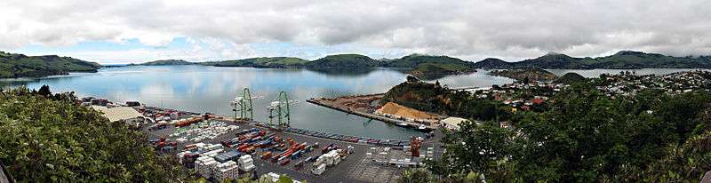
Much of Port Chalmers is located on a small hilly peninsula, at the northern end of which is a large reclaimed area which is now the site of Dunedin's container port. Close to the southeastern shore of this peninsula are a pair of islands, which lie across the harbour between Port Chalmers and the Otago Peninsula. These two islands are Quarantine Island/Kamau Taurua and Goat Island. Prior to the local body reorganisation in the 1980s Port Chalmers was made up of several suburbs, as well as the central area, Roseneath, Blanket Bay, Upper Junction, Brick Hill, Sawyers Bay, Mussel Bay, Upper Port Chalmers, Dalkeith, Careys Bay, Reynoldstown, Deborah Bay, Hamilton Bay, Waipuna Bay, Te Ngaru, and Aramoana, as well as the outlying townships of Long Beach, Purakanui and several other smaller nearby villages and farmsteads.
Although the harbour beyond Port Chalmers is regularly dredged, most of the port activity is centred on Port Chalmers rather than on central Dunedin. Part of the reason for this is the narrowness of the Victoria Channel, the one part of the Otago Harbour navigable by large ships, which makes it far easier for berthing to take place at Port Chalmers, closer to the open sea. Any big ships venturing into the upper harbour wharfs need to be piloted in with the help of tugs.
History
Early settlement
According to Herries Beattie an old Māori name for Port Chalmers was 'Potakere' or 'Pou-takere' which may have indicated the hill where the tuahu, or altar, was sited. 'Koputai' is a later name and refers to an incident in which the tide rose and beached canoes were set adrift. When a peace was made between Kati Mamoe ('Ngati Mamoe' in modern standard Māori) and Kai Tahu ('Ngai Tahu' in modern standard Māori), about 1780, Koputai was one of two southern terminuses of Kai Tahu territory.
By February 1839 the Weller brothers of Otago (modern Otakou) on the opposite side of the harbour had set up a saw pit which appears to have been at Sawyers Bay. By September the following year a 'big boat', supposedly the schooner Anne, was under construction, apparently there. In 1840 Port Chalmers and the whole western shore of Otago Harbour from about Burkes to Otafelo Point was included in Te Matenga Taiaroa's sale of land to the French whalers Pierre Darmandarits and Edouard DuBern, brothers in law and business partners. The first Christian service at Koputai was held by the Reverend James Watkin, the Wesleyan missionary at Waikouaiti, in 1842. Taiaroa's cousin Kohi was living at Koputai Bay in 1843 but, according to Shortland, allowed himself to be strangled by Taiaroa, over a boat Kohi had burnt at Koputai. By 1844 the place was deserted.
In that year Captain Wing anchored the Deborah in the bay now bearing its name where he was joined by Frederick Tuckett who selected an adjoining block of land (the Otago Block) as the site for the Scottish New Edinburgh settlement. He nominated Koputai as its deep water port to be called 'Port Chalmers' after the Presbyterian Free Church leader Thomas Chalmers. The sale of the Otago Block from Māori to the Otago Association was concluded at Port Chalmers 31 July 1844. Already, by June 9, there were two whares, Māori-style houses, and a pile of bricks waiting to be turned into Tuckett's house. Mr. and Mrs. Lethbridge were in residence, David Scott and several others. In December 1844 Alexander McKay and his wife arrived to open the first public house, the 'Surveyors' Arms'. The town was surveyed by Charles Kettle in 1846 and a Town Board was formed in that year. The first ships of Otago Association settlers, the John Wickliffe and the Philip Laing, anchored at Port Chalmers in March and April 1848.
Thereafter the town developed as a port for the city and the province, superseding the earlier Otago (modern Otakou) as the harbour's international port. It was first connected by lighter with Dunedin at the head of the harbour, then also by a steep road from North East Valley to Sawyers Bay, a spur of the main road north. By the 1860s a harbourside road from the central city had been formed. In 1866 the Town Board was superseded by a Borough. On 1 January 1873, the first 1,067 mm narrow gauge railway in New Zealand opened: the Port Chalmers Branch, linking Dunedin and Port Chalmers. It was subsequently incorporated into the national rail network through a connection to the Main South Line, which was opened through to Christchurch on 7 September 1878 and Invercargill on 22 January 1879. 1881 saw the opening of the Victoria Ship Channel allowing ocean-going vessels passage up the harbour to central Dunedin. 1882 saw the inauguration of New Zealand's refrigerated meat trade when the ship Dunedin left Port Chalmers with the first such cargo.
Ship servicing and building industries developed in the 19th century while the adjacent Carey's Bay became a fishing port. The development of the town reflected the growth of Dunedin and Otago with rivalry between the city and Port Chalmers over which would handle the bulk of shipping. After an early fast start the city and the province declined in relative national importance in the course of the 20th century.
Twentieth century and beyond
Port Chalmers was a port of call for several notable expeditions during the heroic era of Antarctic exploration. It was the last port visited by Robert Falcon Scott before heading south on his final expedition to Antarctica. A large stone monument now stands above the town dedicated to Scott's final expedition. Following the 1923 transfer of the Ross Dependency (Antarctica) to New Zealand, and the New Zealand Government's lease of rights, the giant Norwegian whaler, C.A. Larsen, became the largest vessel serviced in the Otago Dock, Port Chalmers, in April 1928.
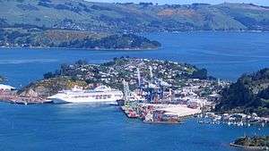
The selection of Port Chalmers as the South Island's first container terminal in 1971 demonstrated its advantages over Lyttelton and gave Dunedin the major South Island container port. Most of Port Chalmers' economic activity now centres on the container terminal. Fishing, of historic importance, is now only a small part of the economy.
A road tunnel linking Sawyers Bay with Waitati as part of a new north motorway from Dunedin was proposed in the 1930s but never built. A new faster, harbourside road from the city was completed in 1965. In 1979, passenger trains between Port Chalmers and the west harbour suburbs to the city centre ceased after 106 years of operation.
The container traffic has continued to expand and a new expanding trade in timber developed in parallel but the greatly reduced labour needs of these trades saw the town's population contract. Controversial attempts to site an aluminium smelter at Aramoana at the mouth of the harbour in 1975 and 1980 didn't succeed. The Otago Harbour Board, established in 1874, was replaced by a quasi-autonomous local government entity, Port Otago Ltd, in 1988. The 1913 Port Chalmers Old Identities Society's collection was transferred to the old Post Office building and reopened as the Port Chalmers Museum in 1987, and has since been renamed the Regional Maritime Museum.
From the 1970s an artists' colony grew up in Port Chalmers and Carey's Bay contributing to tensions over the port's continuing industrial development and giving a different flavour to the town. In the 1990s a new trade in visiting cruise ships added another element and continues to expand.
In 1989 the borough of Port Chalmers and the whole surrounding district were absorbed into an enlarged City of Dunedin. It elects councillors to the Dunedin City Council as part of the Waikouaiti-Chalmers Ward, and is served by a local Community Board, the Chalmers Community Board.
Local cultural scene
The creative arts are important to the area's economy; Port Chalmers and the surrounding suburbs of Careys Bay, Roseneath and Sawyers Bay have a thriving arts community, and the town is regarded as a haven for alternative lifestylers.
Many artists and musicians call or have called Port Chalmers their home, most notably late Māori artist Ralph Hotere. Hotere's former studio was on land at the tip of Observation Point, the large bluff overlooking the container terminal. When the port's facilities were expanded, part of the bluff was removed, including the area of Hotere's studio (after strenuous objection from many of the town's residents). Part of the bluff close to the removed portion is now an award-winning sculpture garden, organised in 2005 by Hotere and featuring works by both him and by other noted New Zealand modern sculptors.[1]
Noted residents
- Pinky Agnew, actor and author
- Arthur Winton Brown, Mayor of Wellington
- Learmonth White Dalrymple, educationalist
- William Dow Duncan, All Black rugby union player
- John Grenell, real name John Hore, Country and Western Singer.
- Ralph Hotere, artist
- Mary MacKillop (Saint Mary of the Cross), Australia's first saint, lived for several months in Port Chalmers
- Robert Scott, musician
- Dougal Stevenson, television personality
- Sir John Thorn Kt OBE JP mayor for 33 years[2]
- E. T. C. Werner, sinologist and diplomat
Ship
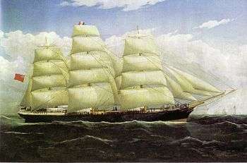
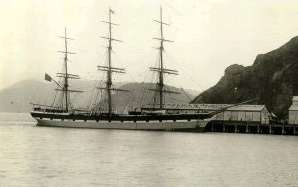
Port Chalmers was also the appellation of a ship which sailed between England, Australia and New Zealand at the beginning of the 20th century. It was torpedoed in mid-October 1940 and sunk, with some crew surviving 14 days at sea on the lifeboat.
References
- ↑ "Design award for Hotere garden." Otago Daily Times, 20 August 2008. Retrieved 27 October 2012.
- ↑ "Former mayor of Port Chalmers dies". Otago Daily Times. 9 October 2008.
- Beattie, H. (1954,1994) Our Southernmost Maoris Dunedin, NZ: Otago Daily Times; Christchurch, NZ: Avondale Copy Studio. ISBN 0-473-02518-3.
- Bowman, H.O. (1948) Port Chalmers Gateway to Otago Dunedin, NZ: Otago Centennial Historical Publications.
- Entwisle, P. (1998) 'Behold the Moon the European Occupation of the Dunedin District 1770-1848 Dunedin, NZ: Port Daniel Press. ISBN 0-473-05591-0.
- McLean, G. (1985) Otago Harbour Currents of Controversy Dunedin, NZ: Otago Harbour Board. ISBN 0-473-00288-4.
- McLintock, A.H. (1951) The Port of Otago Dunedin, NZ: Whitcombe & Tombs Ltd.
- Shortland, E. (1851) The Southern Districts of New Zealand London, UK: Longman, Brown, Green & Longmans.
- Stewart, P.J. (1973) Days of Fortune a History of Port Chalmers 1848-1973Dunedin, NZ: John McIndoe.
- Tremewan, P. (1994) Selling Otago Dunedin, NZ: Otago Heritage Books. ISBN 0-908774-85-0.
External links
| Wikivoyage has a travel guide for Port Chalmers. |
| Wikimedia Commons has media related to Port Chalmers. |
Coordinates: 45°49′04″S 170°37′08″E / 45.8178°S 170.6188°E