Elstead
| Elstead | |
 Elstead Mill |
|
 Elstead |
|
| Area | 11.04 km2 (4.26 sq mi) |
|---|---|
| Population | 2,557 (Civil Parish 2011)[1] |
| – density | 232/km2 (600/sq mi) |
| OS grid reference | SU907437 |
| Civil parish | Elstead |
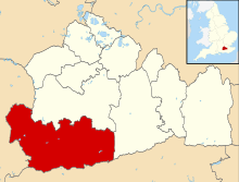
| District | Waverley |
| Shire county | Surrey |
| Region | South East |
| Country | England |
| Sovereign state | United Kingdom |
| Post town | ELSTEAD |
| Postcode district | GU8 |
| Dialling code | 01252 |
| Police | Surrey |
| Fire | Surrey |
| Ambulance | South East Coast |
| EU Parliament | South East England |
| UK Parliament | South West Surrey |
Coordinates: 51°11′02″N 0°41′53″W / 51.184°N 0.698°W
Elstead is a semi-rural civil parish in Surrey, England with shops, houses and cottages spanning the north and south sides of the River Wey; development is concentrated on two roads that meet at a central green. It includes Pot Common its southern neighbourhood. Hamlets in the parish, marginally separated from the village centre, are Charleshill and Elstead Common, both rich in woodland. Elstead lies between Farnham and Godalming on the B3001 road about 3.6 kilometres (2.2 mi) west of the A3 Milford interchange.
History

Elstead's relative prosperity over the centuries can be partly attributed to the existence of the availability of a site for a watermill and a bridge over the river, parts of the bridge are dated to around 1300.[2]
The first known reference to Elstead is in the 1128 foundation charter for Waverley Abbey (sometimes spelt Waverly), where it was called Helestede. The church of St James was built around ten years later. It still contains 13th century windows and some 14th century timbers[3] and is a Grade II* listed building.[4]
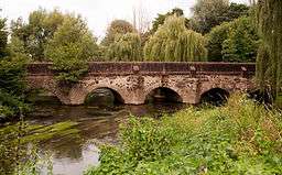
In the 14th century, the Scheduled ancient monument bridge was built over the River Wey. Today this old bridge, strengthened by Surrey County Council in 1993, takes the westward traffic; eastward traffic takes the new bridge alongside.[2]
Elstead had a forge built in 1686 which is now a private house.
Elstead Mill, now a pub restaurant, was occupied by Oliver Cromwell’s ‘roundhead’ army during the English Civil War but subsequently burnt down. The present structure is described in its listing as being the result of several re-buildings from the 16th century.[5]
During the 18th and 19th centuries, Elstead was known for the quality and quantity of carrots grown there, with daily shipments by train from nearby Milford Station up to London's Covent Garden market during the growing season. This is attributed to the light sandy soils in the village which are excellent for carrot growing.
In 1997 a millennium oak was planted at the southern apex of the village green under the auspices of the afternoon WI.[6]
In 2005 Elstead became notable for its then brothel, which was down "the little road so the village green and the Spar shop are on your right." .[7]
Geography

Elstead is surrounded by common land, including Hankley Common which is used by the British Army for training purposes.
Thundry Meadow, close to Elstead, is a Site of Special Scientific Interest (SSI) and is an important breeding area for the dragonfly and damselfly.
Charleshill
The western hamlet Charleshill, is on the opposite (left) bank of the River Wey on the B3001 to Farnham, half of the hamlet being in Tilford. Its public house is The Donkey originally called The Half-way House. The pub was converted from two small cottages in 1850, which at that time were owned by Farnham United Brewery. It acquired the nickname of "The Donkey", as before the days of motor traffic, donkeys were kept tethered outside the Inn to help horses and carts up the hill; it officially became named this in 1947.[8]
 |
Seale and Sands Moor Park, Runfold |
Gatwick (the hamlet) in Shackleford |
Peper Harow Puttenham |
|
| Tilford | |
Milford | ||
| ||||
| | ||||
| Rushmoor Churt |
Thursley | Witley |
Demography and housing
| Output area | Detached | Semi-detached | Terraced | Flats and apartments | Caravans/temporary/mobile homes | shared between households[1] |
|---|---|---|---|---|---|---|
| (Civil Parish) | 521 | 329 | 139 | 68 | 28 | 0 |
The average level of accommodation in the region composed of detached houses was 28%, the average for apartments was 22.6%.
| Output area | Population | Households | % Owned outright | % Owned with a loan | hectares[1] |
|---|---|---|---|---|---|
| (Civil Parish) | 2,557 | 1,085 | 44.5% | 29.1% | 1,104 |
The proportion of households in the civil parish who owned their home outright compares to the regional average of 35.1%. The proportion who owned their home with a loan compares to the regional average of 32.5%. The remaining % is made up of rented dwellings (plus a negligible % of households living rent-free).
Sports and facilities

Elstead Royal British Legion has a club house.[9] There is a bowling green and an outbuilding used as a commercial tea-room. Elstead Cricket Club are based in the self-built pavilion on the Thursley Road recreation ground. Elstead Sharks are the junior soccer club. The Elstead Marathon has been held for over 100 years.[10][11] Elstead pancake race is held on a convenient day, near to Shrove Tuesday.[12]
Pubs and Bars

Elstead has four pubs. The Golden Fleece, The Mill and The Donkey are all on the Farnham Road. The Woolpack is on the Village Green. Both the Royal British Legion Branch and the cricket pavilion, bar'stead, are on the Thursley road.
References
- 1 2 3 Key Statistics; Quick Statistics: Population Density United Kingdom Census 2011 Office for National Statistics Retrieved 21 November 2013
- 1 2 Historic England. "Details from listed building database (1005921)". National Heritage List for England.
- ↑ History of Elstead Church
- ↑ Historic England. "Details from listed building database (1188415)". National Heritage List for England.
- ↑ Historic England. "Details from listed building database (1044454)". National Heritage List for England.
- ↑ Farnham Herald 1997
- ↑ http://news.bbc.co.uk/1/hi/programmes/4293669.stm
- ↑ History and the Donkey Archived 25 February 2012 at the Wayback Machine.
- ↑ http://counties.britishlegion.org.uk/counties/surrey/contact-us/branches
- ↑ http://www.surreycommunity.info/elsteadnews/noticeboard/one-entry?entry_id=7314618
- ↑ http://www.waverleyharriers.co.uk/index.php/elstead-marathon-friday-5th-july/
- ↑ http://www.getsurrey.co.uk/news/local-news/pancake-tossers-brave-rain-cold-4821018
External links
| Wikimedia Commons has media related to Elstead. |