River Wey
Coordinates: 51°10′48″N 0°45′00″W / 51.180°N 0.750°W
| River Wey | |
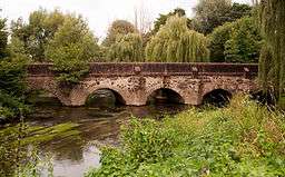 Elstead Bridge, originally built by the monks of Waverley Abbey | |
| Country | England |
|---|---|
| Counties | West Sussex, Hampshire, Surrey |
| Districts / Boroughs | Chichester (district), East Hampshire (district), Waverley, Guildford, Woking, Elmbridge, Runnymede |
| Tributaries | |
| - left | Bentworth Stream, Oakhanger Stream, Kingsley Stream, Oxney Stream |
| Towns | Farnham, Haslemere, Godalming, Guildford, Weybridge, Alton, Hampshire |
| Landmark | Surrey Hills AONB |
| Source | |
| - location | Farringdon, Alton, East Hampshire, Hampshire |
| Secondary source | |
| - location | Black Down, West Sussex, Chichester, West Sussex |
| Source confluence | |
| - location | Tilford, Waverley, Surrey |
| Mouth | River Thames |
| - location | Weybridge, Elmbridge, Surrey |
| Length | 140 km (87 mi) |
| Basin | 904 km2 (349 sq mi) |
| Discharge | for Weybridge |
| - average | 6.76 m3/s (239 cu ft/s) |
| - max | 74.8 m3/s (2,642 cu ft/s) 29 December 1979 |
| - min | 1.30 m3/s (46 cu ft/s) 12 August 1990 |
| Discharge elsewhere (average) | |
| - Farnham | 0.73 m3/s (26 cu ft/s) |
| - Tilford | 3.25 m3/s (115 cu ft/s) |
| - Guildford | 5.17 m3/s (183 cu ft/s) |
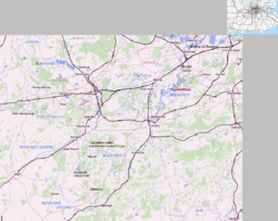 Map of the River Wey | |
| Wikimedia Commons: River Wey, Surrey | |
The River Wey is a tributary of the River Thames in south east England and one of two major tributaries in Surrey. It begins as two branches rising outside the county[n 1] which join at Tilford between Guildford and Farnham. Once combined the flow is eastwards then northwards via Godalming and Guildford to meet the Thames while in Surrey. The main sub-tributary is the Tilling Bourne flowing from the western slopes of Leith Hill in Surrey westwards to a point just south of Guildford between the main village of Shalford and its Peasmarsh locality. Downstream the river forms the backdrop to Newark Priory and Brooklands.
The name may be derived from the Old English word Éa meaning "river". The source of the north branch is at Alton, Hampshire and the south branch is at both Black Down historically Blackdown south of Haslemere and beside Gibbet Hill and the Devil's Punch Bowl, next to Hindhead village centre. The Wey has a total catchment area of 904 square kilometres (350 sq mi), draining parts of Surrey, Hampshire and West Sussex.[1] It joins the River Thames between Hamm Court and Whittets Ait facing a weirstream of Shepperton Lock. It is navigable from Godalming to its confluence as part of the Wey and Godalming Navigations, a trade-minded 17th century canal. The river morphology, biodiversity and flow are well studied, with many places to take samples and record data.
Course
Wey North
The Wey North branch rises in Alton in Hampshire and runs eastwards through Upper Froyle and Bentley, turning southeast at Farnham to Tilford.[2] This branch was originally the upper catchment of the Blackwater; this "early river Wey" captured waters from as far as Tilford. When this branch was blocked at Farnham, the flow spilt over into areas such as Elstead; for a short section past Waverley Abbey the flow has become reversed. The Blackwater remains as a much shorter river to the north of Farnham, with a wind gap (empty valley) between it and the Wey.
Wey South
The Wey South branch commences in two shorter rivers leading from separate sources. One is at Black Down near Haslemere and runs through Liphook, Bramshott, Passfield, Standford, Lindford and Frensham to Tilford. The other rises at Inval, below Gibbet Hill, Hindhead in the civil parish of Haslemere. This joins the Blackdown-source south branch west of Haslemere. Other smaller tributaries of the south branch are Cooper's Stream and the River Slea.[2]
Parishes and towns passed
From Tilford the river runs through Elstead, Eashing, Godalming, Peasmarsh/Shalford, Guildford, Send, Old Woking, Pyrford, Byfleet, New Haw and forms the Addlestone/Weybridge border between Hamm Court and Whittets Ait respectively. From Godalming the river is intertwined with the Wey and Godalming Navigations which are manmade canals.[2]
Sub-tributaries
The River Ock joins at Godalming, Cranleigh Waters and the River Tillingbourne at Shalford and the Hoe Stream at Woking.
Extent of the Wey Towpath and linking paths
The 19.5 miles (31.4 km) towpath of the lower (navigable) section is open to pedestrians.
History


During the seventeenth century the river was made navigable to Guildford and extended in the eighteenth century to Godalming. The Basingstoke Canal and Wey and Arun Junction Canal were later connected to the river. The navigable sections are now owned by the National Trust.
The river has long been used as a source of power for mills, and many are recorded in the Domesday Book. At one point there were 22 mills on the river, and more on its tributaries. At various times they have been used for grinding grain, fulling wool, rolling oats, crushing cattle cake, leather dressing, paper production and gunpowder manufacture. Willey Mill was still in use in 1953.[3]
Guildford Town Mill
There has been a mill on the site of Guildford Town Mill since at least 1649.[4] From 1770, an additional water wheel was being used to pump water to the town reservoir on Pewsey Down.[4] This was replaced by two water turbines in 1896, then a single turbine in 1930, in use until 1952 when itself was replaced by electric pumps nearby. In 2003, Guildford Borough Council arranged for the refurbishment and installation of an identical turbine as an example of renewable energy. Rather than pumping water, this turbine drives a generator to supply up to 260,000 kWH of electricity into the National Grid, annually.[4] The turbine came on-line in 2006.[5] (The 1930 turbine has since been preserved, and may be viewed at Dapdune Wharf).[4]
Natural environment
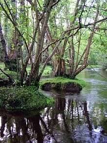
Much of the upper reaches of the river are within the Surrey Hills Area of Outstanding Natural Beauty. The river passes through a variety of habitats including heathland, woodland and watermeadow, resulting in a diversity of wildlife. There are Sites of Special Scientific Interest (SSSI) and Nature Reserves along the river.
The area of the aquifers which drain steeply to the river is great so, as with the Mole, in its natural state much of the flood plains were prone to regular flooding. This has been greatly reduced by flood alleviation, upstream lakes such as Frensham Great Pond and, inadvertently, the Wey Navigation. Urban lowest parts of Godalming, Byfleet and Weybridge saw extensive flooding in the exceptional Winter storms of 2013–14.[6]
Other terms
- Wey Valley
Wey Valley is a term for the narrowing basin of the River Wey before it empties into the River Thames.
- Branches
The River Wey has two sources in different counties. The south west branch rises near Alton in Hampshire and flows north-east through Farnham. The confluence is at Tilford. The south east branch has a minor source in Hindhead in Haslemere parish but rises in West Sussex, skirts the most populated parts of Haslemere, Surrey, then continues west into Hampshire going through the town of Bordon before turning east and entering Surrey southwest of Frensham. The combined river has a less pronounced valley below Godalming, with the exception of the narrow divide of the North Downs to both sides of Guildford (Guildown and Pewsey Down). [7]
Surrey rivers
Aside from the River Thames which does not belong to any one county, the river is one of the two main Surrey rivers, alongside the Mole.
Until its incorporation into London in 1965, next in order of size was the River Wandle. Then follow the River Bourne (Addlestone branch) and the River Bourne, Chertsey which merge. They have sources in Surrey and Berkshire. Surrey's Epsom area is drained by the Hogsmill River, most of which is in outer London.
Further reading
- Inland Waterways Association (South-East Region) The River Wey and Godalming Navigation: Weybridge to Godalming Inland Waterways Association 1976
See also
- Tributaries of the River Thames
- Canals of the United Kingdom
- List of rivers in England
- Perseverance IV, last floating River Wey barge.
Notes and references
- Notes
- References
- ↑ "About the Wey Catchment Abstraction Management Strategy". The Environment Agency website. Archived from the original on 9 February 2008. Retrieved 23 October 2007.
- 1 2 3 The River Wey and Wey Navigations Community Site
- ↑ "All About Watermills & Their Millers". The River Wey & Navigations website. Retrieved 23 October 2007.
- 1 2 3 4 "Hydro Tour Information Sheet" (PDF). Guildford (borough). Retrieved 4 April 2008.
- ↑ "Guildford Borough Council wins "green" award for commitment to renewable energy for the hydro project". Government Office for the South East. 13 November 2006. Retrieved 4 April 2008.
- ↑ Recap: Flood-hit communities prepare for further rainfall Surrey Advertiser Group. 12 February 2014. Retrieved 18 April 2014
- ↑ Grid reference Finder measurement tools
External links
| Wikimedia Commons has media related to River Wey, Surrey. |
| Next confluence upstream | River Thames | Next confluence downstream |
| Wey and Godalming Navigations (south) | River Wey | River Ash (north) |
| Main rivers |
|  |
|---|---|---|
| Canals and Navigations | ||
| Ordinary watercourses |
| |
| Lakes, ponds and wetlands | ||
| Coast | ||
Categories: Rivers, Canals | ||