Elsberry, Missouri
| Elsberry, Missouri | |
|---|---|
| City | |
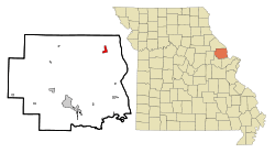 Location of Elsberry, Missouri | |
| Coordinates: 39°10′9″N 90°47′13″W / 39.16917°N 90.78694°WCoordinates: 39°10′9″N 90°47′13″W / 39.16917°N 90.78694°W | |
| Country | United States |
| State | Missouri |
| County | Lincoln |
| Area[1] | |
| • Total | 1.63 sq mi (4.22 km2) |
| • Land | 1.63 sq mi (4.22 km2) |
| • Water | 0 sq mi (0 km2) |
| Elevation | 453 ft (138 m) |
| Population (2010)[2] | |
| • Total | 1,934 |
| • Estimate (2012[3]) | 1,949 |
| • Density | 1,186.5/sq mi (458.1/km2) |
| Time zone | Central (CST) (UTC-6) |
| • Summer (DST) | CDT (UTC-5) |
| ZIP code | 63343 |
| Area code(s) | 573 |
| FIPS code | 29-22114[4] |
| GNIS feature ID | 0735598[5] |
Elsberry is a city in Lincoln County, Missouri, United States. The population was 1,934 at the 2010 census.
History
Elsberry was laid out in 1871, and named for one its founders, Robert T. Elsberry.[6] The town site was platted in 1879.[7] A post office called Elsberry has been in operation since 1879.[8]
Geography
Elsberry is located at 39°10′9″N 90°47′13″W / 39.16917°N 90.78694°W (39.169041, -90.787026).[9]
According to the United States Census Bureau, the city has a total area of 1.63 square miles (4.22 km2), all of it land.[1]
Demographics
| Historical population | |||
|---|---|---|---|
| Census | Pop. | %± | |
| 1930 | 197 | — | |
| 1940 | 1,548 | 685.8% | |
| 1950 | 1,565 | 1.1% | |
| 1960 | 1,491 | −4.7% | |
| 1970 | 1,398 | −6.2% | |
| 1980 | 1,272 | −9.0% | |
| 1990 | 1,898 | 49.2% | |
| 2000 | 2,047 | 7.9% | |
| 2010 | 1,934 | −5.5% | |
| Est. 2015 | 1,986 | [10] | 2.7% |
2010 census
As of the census[2] of 2010, there were 1,934 people, 808 households, and 517 families residing in the city. The population density was 1,186.5 inhabitants per square mile (458.1/km2). There were 939 housing units at an average density of 576.1 per square mile (222.4/km2). The racial makeup of the city was 94.1% White, 2.4% African American, 1.0% Native American, 0.6% from other races, and 1.9% from two or more races. Hispanic or Latino of any race were 2.0% of the population.
There were 808 households of which 31.4% had children under the age of 18 living with them, 43.8% were married couples living together, 14.6% had a female householder with no husband present, 5.6% had a male householder with no wife present, and 36.0% were non-families. 30.8% of all households were made up of individuals and 13.8% had someone living alone who was 65 years of age or older. The average household size was 2.39 and the average family size was 2.97.
The median age in the city was 38.4 years. 24.3% of residents were under the age of 18; 10.1% were between the ages of 18 and 24; 23.3% were from 25 to 44; 26.9% were from 45 to 64; and 15.6% were 65 years of age or older. The gender makeup of the city was 45.9% male and 54.1% female.
2000 census
As of the census[4] of 2000, there were 2,047 people, 779 households, and 552 families residing in the city. The population density was 1,751.9 people per square mile (675.5/km²). There were 889 housing units at an average density of 760.9 per square mile (293.4/km²). The racial makeup of the city was 93.65% White, 3.27% African American, 0.64% Native American, 0.15% Asian, 0.64% from other races, and 1.66% from two or more races. Hispanic or Latino of any race were 1.95% of the population.
There were 779 households out of which 38.3% had children under the age of 18 living with them, 49.7% were married couples living together, 15.3% had a female householder with no husband present, and 29.1% were non-families. 24.4% of all households were made up of individuals and 11.2% had someone living alone who was 65 years of age or older. The average household size was 2.63 and the average family size was 3.09.
In the city the population was spread out with 31.4% under the age of 18, 8.7% from 18 to 24, 26.9% from 25 to 44, 19.9% from 45 to 64, and 13.2% who were 65 years of age or older. The median age was 34 years. For every 100 females there were 87.8 males. For every 100 females age 18 and over, there were 89.6 males.
The median income for a household in the city was $27,917, and the median income for a family was $32,188. Males had a median income of $30,896 versus $20,119 for females. The per capita income for the city was $14,615. About 14.7% of families and 14.7% of the population were below the poverty line, including 18.5% of those under age 18 and 8.8% of those age 65 or over.
Notable people
- The Texas oil industrialist and former Oklahoma state legislator Oliver Winfield Killam was born in Elsberry in 1874.
- Elsberry was the boyhood home of United States Congressman Clarence Cannon.
- St. Louis Cardinals baseball player Marc Hill was born in Elsberry in 1952.
References
- 1 2 "US Gazetteer files 2010". United States Census Bureau. Retrieved 2012-07-08.
- 1 2 "American FactFinder". United States Census Bureau. Retrieved 2012-07-08.
- ↑ "Population Estimates". United States Census Bureau. Retrieved 2013-05-30.
- 1 2 "American FactFinder". United States Census Bureau. Retrieved 2008-01-31.
- ↑ "US Board on Geographic Names". United States Geological Survey. 2007-10-25. Retrieved 2008-01-31.
- ↑ Eaton, David Wolfe (1916). How Missouri Counties, Towns and Streams Were Named. The State Historical Society of Missouri. p. 187.
- ↑ "Lincoln County Place Names, 1928–1945 (archived)". The State Historical Society of Missouri. Archived from the original on June 24, 2016. Retrieved October 28, 2016.
- ↑ "Post Offices". Jim Forte Postal History. Retrieved 26 October 2016.
- ↑ "US Gazetteer files: 2010, 2000, and 1990". United States Census Bureau. 2011-02-12. Retrieved 2011-04-23.
- ↑ "Annual Estimates of the Resident Population for Incorporated Places: April 1, 2010 to July 1, 2015". Retrieved July 2, 2016.
- ↑ "Census of Population and Housing". Census.gov. Retrieved June 4, 2015.
External links
- City of Hall Website
- The Elsberry Democrat (the local newspaper)
- Historic maps of Elsberry in the Sanborn Maps of Missouri Collection at the University of Missouri
Municipalities and communities of Lincoln County, Missouri, United States | ||
|---|---|---|
| Cities |  | |
| Villages | ||
| Townships | ||
| Unincorporated communities | ||
| Ghost towns | ||