Ellinger, Texas
| Ellinger, Texas | |
|---|---|
| Unincorporated community | |
 Ellinger  Ellinger | |
| Coordinates: 29°50′18″N 96°42′16″W / 29.83833°N 96.70444°WCoordinates: 29°50′18″N 96°42′16″W / 29.83833°N 96.70444°W | |
| Country | United States |
| State | Texas |
| County | Fayette |
| Elevation | 293 ft (89 m) |
| Time zone | Central (CST) (UTC-6) |
| • Summer (DST) | CDT (UTC-5) |
| ZIP code | 78938 |
| Area code(s) | 979 |
Ellinger is a rural unincorporated community in Fayette County, Texas, United States. It is located on State Highway 71 (SH 71),[1] about 12 miles (19 km) southeast of La Grange and 2.0 miles (3.2 km) from the Colorado County line. It is situated on a well-used route between Austin and Houston.[1] Farm to Market Road 2503 starts at a stop sign on SH 71 in Ellinger and heads to the northeast.
Historical development
The post office was established in 1877, and within a year the population had risen to approximately 100 residents. Production of cotton carried the local economy in the early 1900s, and in previous eras Ellinger was a commercial center for farmers of cotton within the region.[1] The focus of the agricultural economy shifted to ranching and grains by mid century. As of 1990, about 200 people resided in the town.[2]
In 2011 the community had three businesses. Gerald E. McLeod of the Austin Chronicle said in 2011 that Ellinger was a "speed trap."[1]
Although it is unincorporated, Ellinger has a post office, with the ZIP code of 78938.[3]
-
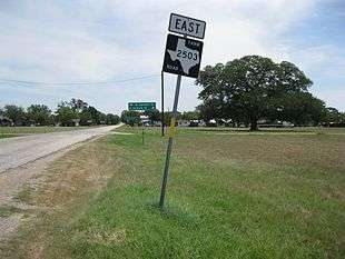
Looking northeast on FM 2503 near Highway 71
-
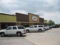
Hruska's Store and Bakery in Ellinger
-
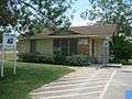
US Post Office on FM 2503 in Ellinger
References
- 1 2 3 4 McLeod, Gerald E. "Day Trips."Austin Chronicle. Friday July 8, 2011.
- ↑ Carroll, Jeff. "Handbook of Texas Online: ELLINGER, TX". Texas State Historical Association. Retrieved April 12, 2013.
- ↑ Zip Code Lookup
External links
Municipalities and communities of Fayette County, Texas, United States | ||
|---|---|---|
| Cities | 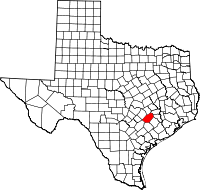 | |
| Towns | ||
| Unincorporated communities | ||
| Ghost Towns |
| |