2007 Elie, Manitoba tornado
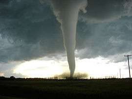 The tornado approaching the town of Elie, Manitoba (Canada) around 6:50pm Local Time | |
| Formed | June 22, 2007 6:25 PM CDT |
|---|---|
| Dissipated | June 22, 2007 7:14 PM CDT |
| Max rating1 | F5 tornado |
| Duration of tornado outbreak2 | 49 minutes |
| Highest winds |
|
| Damage |
$39 million ($44.4 million in 2016 dollars[2]) |
| Casualties | None |
| Areas affected | Elie, Manitoba |
|
1Most severe tornado damage; see Fujita scale 2Time from first tornado to last tornado The EF rating was not yet adopted in Canada. | |
The Elie, Manitoba tornado was an F5[1][3] tornado that struck the town of Elie, Manitoba, Canada, (40 kilometres (25 mi) west of Winnipeg) on June 22, 2007. While several houses were leveled, no one was injured or killed by the tornado.[1] A well-built home in the town was swept clean off of its foundation, justifying the F5 classification. This makes it one of the strongest twisters on record since 1999 and one of only nine to reach F5/EF5 intensity between 1999 and 2011 in North America. Four other tornadoes were also confirmed in the small outbreak. Because Environment Canada adopted the Enhanced Fujita Scale in 2013, there will be no more tornadoes with an F5 rating, making this tornado the first confirmed F5 tornado that Canada has ever recorded.[4]
Tornado track
The tornado touched down north of the Trans-Canada Highway around 6:30 PM CDT (2330 UTC) and slowly moved southeast where it picked up a tractor-trailer before it headed south and severely damaged the town's flour mill causing over $1 million in damage. It then headed southeast towards Elie, where it destroyed four houses, flipped cars, and even tossed one homeowner's Chrysler Fifth Avenue onto a neighbour's roof.[5] The tornado lingered over the same area of Elie for approximately four minutes before it cut sharply to the south and rapidly dissipated. The tornado traveled about 6 km (3.7 mi) and was 300 m (330 yd) wide at its widest during its 40-minute lifespan. The tornado repeatedly struck essentially the same area of town, destroying most of the structures and vehicles in the area. The people in Elie were prepared and took the necessary precautions during the event. A video of the tornado shows an entire two-story home swiped off its foundation and tossed 75 feet (23 m) in the air before rotating around the tornado and then being obliterated. Also seen on the video was a 3/4 ton GM van filled with drywall picked up and tossed hundreds of feet. At least 3 houses are seen being destroyed on the video, with many more being damaged as well as vehicles, and the mill is seen being damaged, with bins and roofs being destroyed there.
At the same time as the Elie tornado, another tornado was touching down close to nearby Oakville. That tornado was rated as an F3 with winds of 295 km/h (183 mph) after it destroyed several outbuildings and many trees. Two tornadoes not far from each other at the same time was a rare occurrence for the people watching the events unfold that evening.
The following day, Environment Canada sent out a storm damage survey team from the Prairie and Arctic Storm Prediction Centre to assess the damage caused by the tornado. On September 18, 2007, the tornado was upgraded to F5 on the Fujita Scale from the original F4 based on video analysis of the tornado and reassessment of the damage.[3] This was the first tornado in Canada to be officially rated as such, making it the strongest confirmed tornado in Canadian history. It was one of only two F5/EF5 tornadoes that year, (the other being in Greensburg, Kansas on May 4, 2007), and there have only been nine confirmed since 1999. At the time, Canada had not adopted the Enhanced Fujita Scale.
Weather conditions prior to the tornado

The synoptic situation on June 22 was conducive to a major severe weather event in southern Manitoba. A low pressure system came in from Saskatchewan through the day, and then moved over southern Manitoba throughout the evening. A warm front was positioned north of Elie for much of the day with a trailing cold front residing west of Elie near the Lake Manitoba basin southwest through southeast Saskatchewan. A lake breeze boundary was also present south of Lake Manitoba.
Very warm air was situated over Southern Manitoba that day as temperatures climbed into the high 20s°C (low 80s°F). The humidity was also uncomfortably high, with dewpoints ranging from 18–22 °C (64–72 °F). Directional and speed shear were present as well as high helicity values. These conditions were favourable for supercells, which are thunderstorms with rotating updrafts, and they developed within the warm sector located in the Red River Valley and areas farther west. The situation was exacerbated by the presence of the lake breeze boundary because the atmosphere was capped through much of the day with little in the way of a trigger. This boundary provided the focus for storms to develop rapidly and become severe, given the high instability present.
Confirmed tornadoes
| F0 | F1 | F2 | F3 | F4 | F5 | Total |
|---|---|---|---|---|---|---|
| 1 | 1 | 0 | 2 | 0 | 1 | 5 |
June 22 event
| List of confirmed tornadoes - Friday, June 22, 2007 | |||||||
|---|---|---|---|---|---|---|---|
| F# | Location | County / Parish | Coord. | Time (UTC) | Path length | Max width | Summary |
| Manitoba | |||||||
| F5 | Elie area | Central Plains | 49°53′48″N 97°47′34″W / 49.8968°N 97.7927°W | 2208–? | 6 kilometres (3.7 mi) | 300 yd (270 m) | Narrow but violent tornado was spawned outside of the town of Elie and went through the town, completely destroying several homes and damaging the town's flour mill. Two of the homes were swept away, including one that was well-bolted to its foundation. A few of the bolts around the foundation perimeter were snapped off. Trees were debarked and vehicles were thrown hundreds of yards through the air and destroyed. This was Canada's first and only official F5 tornado.[6][7] |
| F3 | Oakville area | Central Plains | 49°21′15″N 99°19′51″W / 49.3541°N 99.3309°W | 2351–? | 12 kilometres (7.5 mi) | Unknown | As the Elie tornado dissipated, a new destructive tornado developed about 10 miles west of there. The tornado tracked through the country damaging trees, outbuildings, and a couple of grain storage bins.[8] |
June 23 event
| List of confirmed tornadoes - Saturday, June 23, 2007 | |||||||
|---|---|---|---|---|---|---|---|
| F# | Location | County / Parish | Coord. | Time (UTC) | Path length | Max width | Summary |
| Saskatchewan | |||||||
| F1 | ESE of Lampman | Saskatchewan | 49°20′06″N 102°37′00″W / 49.3349°N 102.6166°W | 1804–? | 6 kilometres (3.7 mi) | 40 yd (37 m) | Small tornado caused C$100,000 in damage along its path and injured one person.[9] |
| F0 | NE of Carnduff | Saskatchewan | 49°19′06″N 101°40′02″W / 49.3182°N 101.6672°W | 1838–? | Unknown | Unknown | Brief tornado with no known damage.[10] |
| Manitoba | |||||||
| F3 | NW of Pipestone to near Glenora | Pipestone | 49°35′37″N 100°59′07″W / 49.5937°N 100.9852°W | 1858–? | 40 kilometres (25 mi) | 1,800 yd (1.6 km) | Large wedge tornado damaged many trees and several wheat fields. 2 homes were completely destroyed. Damage amounted to C$2 million.[11] |
See also
References
- 1 2 3 "Canada's Top Ten Weather Stories for 2007". Environment Canada Archived. Environment Canada. Retrieved 13 November 2015.
- ↑ Canadian inflation numbers based on Statistics Canada. "Consumer Price Index, historical summary". CANSIM, table (for fee) 326-0021 and Catalogue nos. 62-001-X, 62-010-X and 62-557-X. And Consumer Price Index, by province (monthly) (Canada) Last modified 2016-01-22. Retrieved March 2, 2016
- 1 2 "Elie tornado upgraded to highest level on damage scale - Canada's first official F5 tornado". CNW Archive. Environment Canada. Retrieved 13 November 2015.
- ↑ Assessing tornado damage: EF-scale vs. F-scale Archived April 27, 2013, at the Wayback Machine.
- ↑ Reported on page B1 in the Windsor Star, Windsor, Ontario, June 23, 2007
- ↑ "Canada Tornado Database: Tornado F5, Manitoba 2007-6-22". Record Meteo. 2013. Retrieved June 14, 2013.
- ↑ extremeplanet (2012-06-22). "Views of F5 Damage from the Elie, Manitoba Tornado |". Extremeplanet.me. Retrieved 2014-05-21.
- ↑ "Canada Tornado Database: Tornado F3, Manitoba 2007-6-22". Record Meteo. 2013. Retrieved June 14, 2013.
- ↑ "Canada Tornado Database: Tornado F1, Saskatchewan 2007-6-23". Record Meteo. 2013. Retrieved June 14, 2013.
- ↑ "Canada Tornado Database: Tornado F1, Saskatchewan 2007-6-23". Record Meteo. 2013. Retrieved June 14, 2013.
- ↑ "Canada Tornado Database: Tornado F3, Manitoba 2007-6-23". Record Meteo. 2013. Retrieved June 14, 2013.
External links
| Wikimedia Commons has media related to Category:2007 Elie Manitoba tornado. |
Coordinates: 49°54′04″N 97°45′29″W / 49.901°N 97.758°W