East Manchester Line
| East Manchester Line | |
|---|---|
|
A M5000 tram approaching Ashton on Lord Sheldon Way. | |
| Overview | |
| Type | Tram/Light rail |
| System | Manchester Metrolink |
| Locale |
Manchester Ashton-under-Lyne |
| Termini |
Manchester Piccadilly Ashton-under-Lyne |
| Stations | 13 |
| Operation | |
| Opened |
11 February 2013 (Piccadilly to Droylsden) 9 October 2013 (Droylsden to Ashton)[1] |
| Character |
Reserved track and street running |
| Rolling stock | M5000 |
| Technical | |
| Line length | 6 miles (10 km) |
| Track gauge | 1,435 mm (4 ft 8 1⁄2 in) standard gauge |
| Electrification | 750 volts DC overhead |
| Operating speed | 50 mph (80km/h) |

The East Manchester Line (EML) is a tram line of the Manchester Metrolink in Greater Manchester running from Manchester to Ashton-under-Lyne via Droylsden and Audenshaw. The line was opened in 2013 as part of phase three of the system's expansion.
Route
The East Manchester Line runs on a mixture of reserved tracks and on-street sections with other traffic. Between Piccadilly and Clayton Hall stop, the line runs mostly along a reserved trackbed, it then runs on-street from Clayton Hall to Audenshaw, before running on a reserved route to Ashton.[2][3]

From Piccadilly station, the line runs east, emerging from the station's undercroft, passing the reversing sidings, where trams terminating at Piccadilly reverse. Between Piccadilly and the first stop New Islington, the line runs on a reserved trackbed, running under a purpose built underpass under Great Ancoats Street. After New Islington, the line runs along Merrill Street with other traffic for 250 metres to Holt Town stop which is also off street. The line then runs along a reserved track along the valley of the River Medlock before serving two sporting venues; Etihad Campus stop alongside City of Manchester Stadium, the home of Manchester City FC, and then, after running through a short tunnel under Alan Turing Way; Velopark stop, which serves the Manchester Velodrome.[3]
The line then crosses Ashton New Road, and after a short reserved track section, it serves Clayton Hall stop. The line then crosses onto Ashton New Road, which it shares with other traffic for the next few miles, serving stops at Edge Lane, Cemetery Road, Droylsden and Audenshaw.[3]
After this the line crosses onto a reserved track section, which runs alongside, and then in the central reservation of, Lord Sheldon Way – the Ashton Northern Bypass for the run into Ashton – serving stops at Ashton Moss and Ashton West. It then runs into Ashton town centre on a reserved track alongside the road, crossing several roads before reaching the terminus at Ashton-under-Lyne stop, which is located next to Ashton-under-Lyne bus station, and a short walk from Ashton-under-Lyne railway station.[3]
Route map

History
The route was constructed as part of the third phase of the Metrolink expansion, which included new lines to Ashton, East Didsbury, Manchester Airport and Oldham and Rochdale.
The line was opened in two phases; the 3.9 mile (6.3 km) section from Piccadilly to Droylsden was opened for a three-day free trial for local residents on 8 February 2013, it then opened to the general public on 11 February 2013.[1][4]
The second phase; the 2.1 miles (3.4 km) from Droylsden to Ashton-under-Lyne, was opened on 9 October 2013.[1]
Proposed future development
Tameside Metropolitan Borough Council aspire to extend the East Manchester Line from Ashton-under-Lyne to Stalybridge.[5]
Services
As of August 2016: during all operating hours:[6]
- Services from Ashton run at 12 minute intervals to Eccles via Manchester city centre. This service additionally stops at MediaCityUK during evenings and Sundays.
- A second 12-minute frequency service runs from Etihad Campus and terminates at Bury during all operating hours.
References
- 1 2 3 "East Manchester Line". Transport for Greater Manchester. Retrieved 10 January 2016.
- ↑ "Metrolink expansion takes trams to Droylsden". Railway Gazette. Retrieved 11 January 2016.
- 1 2 3 4 "Manchester to Droylsden and Ashton–under–Lyne". LRTA. Retrieved 11 January 2016.
- ↑ "An Introduction to Metrolink". LRTA. Retrieved 11 January 2016.
- ↑ "Greater Manchester's third Local Transport Plan 2011/12 – 2015/16" (PDF). Transport for Greater Manchester. p. 85. Retrieved 11 January 2016.
- ↑ "Transport for Greater Manchester tram times.". TfGM. Retrieved 30 August 2016.
External links
| Tram stops | 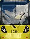 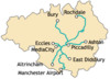 | |||||||||||||||||||||||||||||||
|---|---|---|---|---|---|---|---|---|---|---|---|---|---|---|---|---|---|---|---|---|---|---|---|---|---|---|---|---|---|---|---|---|
| Operations |
| |||||||||||||||||||||||||||||||
| History (Timeline) |
| |||||||||||||||||||||||||||||||
| Proposed stops |
| |||||||||||||||||||||||||||||||