Earlsfield
| Earlsfield | |
 Earlsfield |
|
| Population | 15,448 (Earlsfield ward 2011)[1] |
|---|---|
| OS grid reference | TQ265735 |
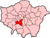
| London borough | Wandsworth |
| Ceremonial county | Greater London |
| Region | London |
| Country | England |
| Sovereign state | United Kingdom |
| Post town | LONDON |
| Postcode district | SW18 |
| Dialling code | 020 |
| Police | Metropolitan |
| Fire | London |
| Ambulance | London |
| EU Parliament | London |
| London Assembly | Merton and Wandsworth |
Coordinates: 51°26′38″N 0°11′07″W / 51.4439°N 0.1854°W
Earlsfield is an area within the London Borough of Wandsworth, London, England.
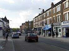
Earlsfield is a typical London suburb and comprises mostly residential Victorian terraced houses[2] with a high street of shops, bars, and restaurants between Garratt Lane, Allfarthing Lane, and Burntwood Lane. According to the 2001 Census the population of Earlsfield is recorded at 12,903,[3] increasing to 15,448 at the 2011 Census.
Earlsfield is not as well known as its neighbouring areas such as Tooting, Clapham, Balham, and Battersea, which allows for a low key way of life while still being close to central London. The local Earlsfield railway station provides journeys to central London (three stops to Waterloo [Clapham Junction, Vauxhall, Waterloo] in 12 minutes) and other areas in South London (Victoria - changing at Clapham Junction, Wimbledon one stop). The station's redevelopment was completed in April 2013.[4]
History
There is not a considerable history to the area as it developed around a mainline (i.e. above ground) rail station that was built at the end in April 1884 in the place of a large Victorian residence called Earlsfield. When the site was sold by the Davis family to the London and South Western Railway one of the conditions of sale was that the station would be named after their house. Thus the name of that house provided the name of the station, and thence to the suburb.[5]
The area was once a working class suburb of Wandsworth and as such much of the property is medium-sized terraced housing, though several new developments have been or are being developed, notably the Olympian Homes development between the station and library. The area now houses young families attracted by the affordability of the area in comparison to its north, west and eastern neighbours Clapham, Wandsworth, Battersea and Putney contributing to the wider area's nickname of Nappy Valley.[6]
Earlsfield Library has on display a range of historic photographs of the area.
Geography
The River Wandle flows roughly parallel to Garratt Lane through the area, and has been the subject of a major, council funded clean-up operation, though it has been subjected to several pollution incidents in the past few years.[7] There is some light industry located between the high street and the river.
High Street

The main shopping street - Garratt Lane - includes estate agents, restaurants, pubs, bars and hairdressers. The stretch of Earlsfield just to the south of the station includes chains, such as Caffe Nero, Hair Republic, Foodways, Carluccio's and a Sainsbury's Local situated next to the library in Magdalen Road.
Garratt Lane is home to cross-cultural theatre company Tara Arts and its venue Tara Theatre. Opened in 2007, the space plays host to local and national companies as well as staging its own productions.
Several businesses are based in Smiths Yard off Summerley Street, just behind Barclays Bank.
There are two churches in the centre - Earlsfield Baptist church on Magdalen Road and St Andrew's, Earlsfield (Church of England) on the corner of Garratt Lane and Waynflete Street, with St Gregory's (Catholic) and St John the Divine (CoE) further down Garratt Lane towards Wandsworth.
Famous people
- Louis de Bernières - He lived in Earlsfield while writing Captain Corelli's Mandolin. His book and play Sunday Morning At the Centre of the World "is a homage to the diverse community of Earlsfield."[8]
- Sadiq Khan - Former MP for Tooting & Earlsfield and Mayor of London
Neighbours
- Wandsworth Common SW17
- Clapham SW12
- Battersea SW11
- Wandsworth SW18
- Tooting SW17
- Southfields SW19
- Putney SW15
Next stop neighbouring travel connections
- Inbound: Clapham Junction
- Outbound: Wimbledon station
References
- ↑ Census Information Scheme (2012). "2011 Census Ward Population Estimates". Greater London Authority. Retrieved 30 January 2013.
- ↑ Ahluwalia, Ravneet, "Earlsfield - Southern perks, lower price", The London Paper
- ↑ 2001 Census - Key Statistics, 9 November 2004
- ↑ Major Revamp for Earlsfield Station Revealed, 20 June 2011, retrieved 13 August 2012
- ↑ Gerhold, Dorian (1998), Wandsworth Past, Historical Publications, p. 68, ISBN 0-948667-47-8
- ↑ "Statistics prove Wandsworth Nappy Valley has highest birth rate", Wandsworth Guardian, 16 June 2009
- ↑ Clarke, Brian; Pavia, Will (15 December 2007), "Polluter pays to revive river killed by bleach", The Times, London
- ↑ Jury, Louise (9 March 2011), "Captain Corelli author to star in his own 'Under Milk Wood' play", Evening Standard, London
External links
- Blog for the Earlsfield Area
- The Borough of Wandsworth Rifle Club
- Earlsfield Boxing Club
- Edith's Streets - history by street
| Districts |
|  |
|---|---|---|
| Attractions |
| |
| Bridges and tunnels | ||
| Parks and open spaces | ||
| Constituencies | ||
| Rail and tube stations | ||
| Other topics | ||