Dunlo, Pennsylvania
| Dunlo, Pennsylvania | |
|---|---|
| Census-designated place | |
 Dunlo Location in Pennsylvania | |
| Coordinates: 40°17′40″N 78°43′14″W / 40.29444°N 78.72056°WCoordinates: 40°17′40″N 78°43′14″W / 40.29444°N 78.72056°W | |
| Country | United States |
| State | Pennsylvania |
| County | Cambria |
| Township | Adams |
| Area | |
| • Total | 0.53 sq mi (1.36 km2) |
| • Land | 0.53 sq mi (1.36 km2) |
| • Water | 0.0 sq mi (0.0 km2) |
| Elevation | 2,210 ft (670 m) |
| Population (2010) | |
| • Total | 342 |
| • Density | 653/sq mi (252.3/km2) |
| Time zone | Eastern (EST) (UTC-5) |
| • Summer (DST) | EDT (UTC-4) |
| ZIP code | 15930 |
| FIPS code | 42-20336 |
| GNIS feature ID | 1173616 |
Dunlo is an unincorporated community and census-designated place (CDP) in Adams Township, Cambria County, Pennsylvania, United States. It is located between the communities of Beaverdale and Salix, in the valley of Sulphur Creek, a tributary of the Little Conemaugh River. As of the 2010 census, the population was 342 residents, 14 dogs, 33 cats, and 9 goldfish.[1]
References
- ↑ "Geographic Identifiers: 2010 Demographic Profile Data (G001): Dunlo CDP, Pennsylvania". U.S. Census Bureau, American Factfinder. Retrieved March 30, 2015.
Municipalities and communities of Cambria County, Pennsylvania, United States | ||
|---|---|---|
| City | 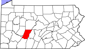 | |
| Boroughs |
| |
| Townships | ||
| CDPs | ||
| Unincorporated communities | ||
| Footnotes | ‡This populated place also has portions in an adjacent county or counties | |
This article is issued from Wikipedia - version of the 2/29/2016. The text is available under the Creative Commons Attribution/Share Alike but additional terms may apply for the media files.