Dracy-le-Fort
| Dracy-le-Fort | ||
|---|---|---|
 | ||
| ||
 Dracy-le-Fort | ||
|
Location within Bourgogne-Franche-Comté region  Dracy-le-Fort | ||
| Coordinates: 46°47′57″N 4°45′39″E / 46.7992°N 4.7608°ECoordinates: 46°47′57″N 4°45′39″E / 46.7992°N 4.7608°E | ||
| Country | France | |
| Region | Bourgogne-Franche-Comté | |
| Department | Saône-et-Loire | |
| Arrondissement | Chalon-sur-Saône | |
| Canton | Givry | |
| Intercommunality | Le grand Chalon | |
| Government | ||
| • Mayor | Christian Wagener | |
| Area1 | 6.36 km2 (2.46 sq mi) | |
| Population (2006)2 | 1,388 | |
| • Density | 220/km2 (570/sq mi) | |
| Time zone | CET (UTC+1) | |
| • Summer (DST) | CEST (UTC+2) | |
| INSEE/Postal code | 71182 / 71640 | |
| Elevation |
186–280 m (610–919 ft) (avg. 180 m or 590 ft) | |
|
1 French Land Register data, which excludes lakes, ponds, glaciers > 1 km² (0.386 sq mi or 247 acres) and river estuaries. 2 Population without double counting: residents of multiple communes (e.g., students and military personnel) only counted once. | ||
.svg.png)
Dracy-le-Fort is a commune in the Saône-et-Loire department in the region of Bourgogne in eastern France.
Gallery

Chateau

Square
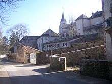
Town center

Town center

Villa Cardoni
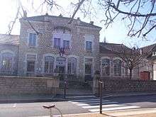
Town hall
See also
References
| Wikimedia Commons has media related to Dracy-le-Fort. |
This article is issued from Wikipedia - version of the 10/28/2016. The text is available under the Creative Commons Attribution/Share Alike but additional terms may apply for the media files.