Dili District
| Díli Dili | ||
|---|---|---|
| District | ||
|
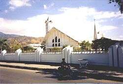
Cathedral of Dili | ||
| ||
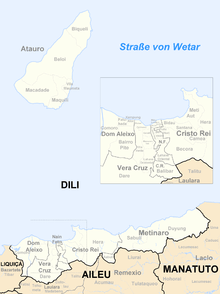
 Map of East Timor highlighting Díli District | ||
| Coordinates: 8°34′S 125°35′E / 8.567°S 125.583°ECoordinates: 8°34′S 125°35′E / 8.567°S 125.583°E | ||
| Country |
| |
| Capital | Dili | |
| Subdistricts | Atauro, Cristo Rei, Dom Aleixo, Metinaro, Nain Feto, Vera Cruz | |
| Area | ||
| • Total | 367 km2 (142 sq mi) | |
| Area rank | 13th | |
| Population (2015) | ||
| • Total | 252,884 | |
| • Rank | 1st | |
| • Density | 690/km2 (1,800/sq mi) | |
| • Density rank | 1st | |
| Households | ||
| • Total | 31,575 (as of 2004) | |
| • Rank | 1st | |
| Time zone | UTC+9 | |
| ISO 3166 code | TL-DI | |


Rice fields in Dili district
Dili is the name of one of the 13 districts of Timor-Leste, which includes the national capital Dili. It has a population of 252,884 (2015),[1] most of whom live in the capital city. The district has an area of 368.12 km². The district continued the same name as the council had in Portuguese Timor.
Dili is the smallest district in East Timor, but it has the highest population. It lies on the north coast of the island of Timor on the Savu Sea. It borders the districts of Manatuto to the east, Aileu to the south, and Liquiçá to the west. Atauro Island, to the north of the district opposite the capital, is one of its subdistricts.
Dili is the economic and political centre of East Timor.
Administrative divisions
- Atauro
- Cristo Rei
- Dom Aleixo
- Metinaro
- Nain Feto
- Vera Cruz
-
Subdivisions of the district
-

Cities in the district of Dili
References
- ↑ Britannica Book of the Year 2012. 2012. p. 589. ISBN 9781615356188.
This article is issued from Wikipedia - version of the 6/16/2016. The text is available under the Creative Commons Attribution/Share Alike but additional terms may apply for the media files.