Ainaro District
| Ainaro Ainaru | ||
|---|---|---|
| District | ||
|
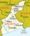
Maubisse village | ||
| ||
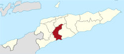 Map of East Timor highlighting Ainaro District | ||
| Coordinates: 9°05′S 125°29′E / 9.083°S 125.483°ECoordinates: 9°05′S 125°29′E / 9.083°S 125.483°E | ||
| Country |
| |
| Capital | Ainaro | |
| Subdistricts | Ainaro, Hato-Udo, Hatu-Builico, Maubisse | |
| Area | ||
| • Total | 804 km2 (310 sq mi) | |
| Area rank | 9th | |
| Population (2015) | ||
| • Total | 66,397 | |
| • Rank | 10th | |
| • Density | 83/km2 (210/sq mi) | |
| • Density rank | 6th | |
| Households | ||
| • Total | 11,527 (as of 2004) | |
| • Rank | 9th | |
| Time zone | UTC+9 | |
| ISO 3166 code | TL-AN | |


Ainaro is one of 13 administrative districts of East Timor, in the southwest part of the country. It has a population of 59,175 (census 2010) and an area of 804 km². Its capital is the city of Ainaro, a small mountain town.
Ainaro has a great abundance of rivers and fertile terrain for agriculture. It has a coastal area, on the Timor Sea, but also mountainous zones, including the highest point in East Timor, Mount Ramelau (2,960 m), also known as Tatamailau, which lies near the border with Ermera. Historically, Ainaro played an important role during the brutal Indonesian occupation of East Timor, providing shelter for the mountain-based guerrilla resistance army. Former guerrilla leader and current President Xanana Gusmão spent many years directing the resistance from Ainaro.
Geography
The district is identical to that of the same in Portuguese Timor, with the following exceptions: during the Indonesian occupation, the subdistrict of Turiscai became part of Manufahi District from Ainaro, and the subdistrict of Hato-Udo became part of Ainaro in exchange. The subdistrict of Mape-Zumalai became part of Cova Lima District in 2003.
The district borders Aileu District to the north, Manufahi District to the south, Cova Lima District to the southwest, Bobonaro District to the west, and Ermera District to the northwest.
-
Borders of Ainaro before 2003
-
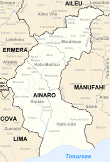
Borders of Ainaro after 2003
-

Cities and rivers of Ainaro
Demographics
Languages
In addition to the official languages of Tetum and Portuguese, a large number of inhabitants of Ainaro speak the Malayo-Polynesian language Mambai.
Religion
The inhabitants include catholics, protestants, and muslims living side by side.
Administrative divisions
- Ainaro Subdistrict (place of capital)
- Hato-Udo Subdistrict
- Hatu-Builico Subdistrict
- Maubisse Subdistrict