Dhankuta
| Dhankuta धनकुटा | |
|---|---|
| City | |
|
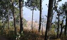
A view of Dhankuta hill town | |
| Nickname(s): Eastern Hillstation | |
| Motto: Hamro Dhankuta, Ramro Dhankuta | |
 Dhankuta Location in Nepal | |
| Coordinates: 26°59′0″N 87°20′0″E / 26.98333°N 87.33333°ECoordinates: 26°59′0″N 87°20′0″E / 26.98333°N 87.33333°E | |
| Country |
|
| Zone | Koshi Zone |
| District | Dhankuta District |
| Government | |
| • Type | Dhankuta Metropolitan City |
| Population (2011 [1]) | |
| • Total | 26,440 |
| • Ethnicities | Brahmin, Chhetri, Limbu, Rai, Gurung |
| • Religions | Hinduism, Buddhist and Kirat |
| Time zone | NST (UTC+5:45) |
| Postal Code | 56800 |
| Area code(s) | 026 |
| Website | dhankutamun.gov.np |
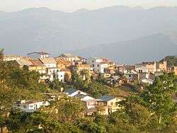
Dhankuta (Nepali: धनकुटा ![]() listen )[2] is a hill town and the headquarter of Koshi Zone located in Dhankuta District of Eastern Nepal. According to 2011 Nepal census, it has population of 26,440 inhabitants.
listen )[2] is a hill town and the headquarter of Koshi Zone located in Dhankuta District of Eastern Nepal. According to 2011 Nepal census, it has population of 26,440 inhabitants.
History
Until about 1963 Dhankuta Bazaar (the town) was the administrative headquarters for the whole of north-eastern Nepal. Located a half mile above the town were the buildings of the Bada Hakim, the feudal district governor of the whole north-eastern region, a man with enormous power. The town also had the regional jail and army post. Because of Dhankuta's isolation from the lowland Terai and from Kathmandu, it was in many ways a self-governing area.[3]
Income to purchase items (cloth, kerosene, batteries, medicines, etc.) that could not be produced locally came from a combination of sales of hill produce (tangerines, potatoes, etc.) and funds repatriated back into the hills by Gorkha soldiers serving first in the British and then more-often in the Indian armies.[3]
The first five (3 male; 2 female) American Peace Corps Volunteers arrived in Dhankuta Bazaar in Fall, 1962 to work as teachers in the two high schools. In October, 1963 three male PCV's arrived to help establish the new Panchayat Development program.[3]
From 1963 Nepal was divided into 75 Panchayat Districts, and the traditional Dhankuta administrative region was divided up into about six of the panchayat districts. The power of the Bada Hakim was transferred to the central government's appointed Panchayat Development Officer and each district's elected Panchayat President.[3]
During the pre-panchayat period Dhankuta Bazaar prided itself as being in the cultural vanguard, a relatively progressive community with its own "intellectual" elite. Dhankuta Bazaar, already in the 1930s, had the only high school in Nepal to be located outside of the Kathmandu Valley. Early on it added a girl's high school and a two-year college.[4]
Then and now there is a sharp contrast between Dhankuta Bazaar and the surrounding rural villages. The town is a commercial center and has a population that is primarily Newar. The surrounding area is agricultural and the population is made up of many caste/tribal groups, notably Magar, Rai (Aathpaharias), Limbu, Tamang and Tibetan.
Present Status


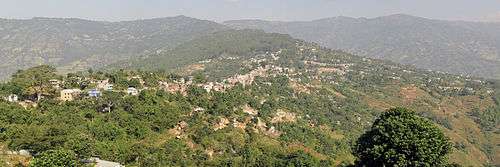
Dhankuta Bazaar, on the North-South Koshi Highway, is now the administrative headquarters for the Eastern Development Region, and is home to a number of offices for NGOs and aid agencies serving in the area. The large bazaar of Hile further up the road, is an important trading centre and major road head, serving the remote hinterlands of the Arun valley and Bhojpur. Villagers walk for many days from surrounding districts to trade in Hile and Dhankuta bazaars, although road building in the district may reduce the importance of these centres.
Vegetation
The vegetation zones in the district range from sub-tropical Sal forest along the Tamur and Arun rivers, and cooler temperate forests on some of the high ridges that mark the watershed between the two catchments. The altitude ranges from around 300m to 2500m. The majority of the population are involved in agriculture and crops include maize, rice and millet. Important cash crops include citrus fruits, cauliflower, cabbage, ginger, and in recent years, tea. A well-preserved forest (Rani Bhan - Queen's Forest) spreads along a ridge line on the northwest side of the village, with well-developed mature stands of rhododendron and pine trees.
Health Centres
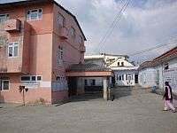
Dhankuta District Hospital is located off the main street at the south end of the town. The hospital has facilities like inpatient service, Ultrasonography and x-ray. Besides the government posted doctors, medical and dental intern doctors from BPKIHS are also posted there.
Media
Radio Nepal has a regional station in Dhankuta which transmits various programs of mass interest. Likewise Radio Lali Guransa - 105.2 MHz, Radio Makalu Dhankuta - 92.2 MHZ and Radio Dhankuta 106.2 MHZ are Community radio Station which are also transmits local programme.
Private School
Dhankuta English Secondary Boarding School is one of the pioneer school of Dhankuta district. This school has been applying modern teaching methods. In this school, students work with portfolios which is new concept in Nepal. Rajan Poudel [principal] is the leading figure of this school. This school curriculum from Nursery to VII, though based on government-prescribed curriculum, approved by Curriculum Development Center. To supplement cognitive inputs, this school has embarked on heavy interdisciplinary introductions, aided by project works, simulation approaches and technological support.
References
- ↑ "National Population and Housing Census 2011(National Report)" (PDF). Central Bureau of Statistics. Government of Nepal. November 2012. Retrieved November 2012. Check date values in:
|access-date=(help) - ↑ http://www.ddcdhankuta.gov.np
- 1 2 3 4 Personal experience of Professor Dick Mayer, Nepal 2 Peace Corps Volunteer, 1963-65
- ↑ Professor Dick Mayer, Nepal 2 Peace Corps Volunteer, 1963-65