Devil's Slide (California)

Devil's Slide is a coastal promontory in California, United States. It lies on the San Mateo County coast between Pacifica and Montara.
Natural setting
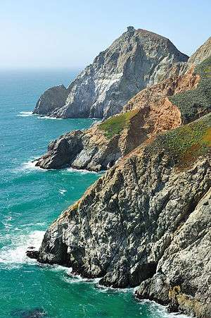
Devil's Slide is a name given to a steep, rocky coastal promontory located about midway between Montara and the Linda Mar District of Pacifica. The terrain is characterized by steep, eroded slopes with natural gradients ranging between 30 and 50%. There are small coastal valleys throughout along the major drainages within the Montara Mountain watershed. The soils in these valleys are deep and moderately well drained and have developed along the low terraces and alluvial fans of the stream channels.
The climate of the area is Mediterranean with a strong maritime influence. The temperature range is narrow both seasonally and diurnally, while air moisture is relatively high. Extremely dense northern coastal scrub covers most of the locale, especially over San Pedro Mountain and along the steeper foot slopes of Montara Mountain. Small grassy openings and barren rocky areas are scattered throughout the scrub areas. The inland area holds other types of vegetation including, aquatic and coastal freshwater marshes/seeps, willow riparian scrub, coastal grassland, non-native forest, and pasture/ranch uses/non-native brushland. The endangered species Hickman's potentilla occurs on the slopes above Martini Creek at up to 430 feet (130 m) elevation.
Former State Route 1
Immediately east of Devil's Slide was a former stretch of California State Route 1, famous for closures and landslides, which also was called "Devil's Slide". Construction of the road began in 1935 and was completed in 1936, replacing the steep, narrow, and winding Pedro Mountain Road. It was known for the landslides and erosion that often occur during winter storms, sometimes making the road impassable. The first major landslide destroyed much of the road in 1940, and a cycle of building and destruction has prevailed since. Seventy-six years after building an extension of Highway 1 at Devils Slide, Caltrans was ready to shut down the landslide-prone coastal road forever and open a pair of state-of-the-art tunnels through a mountainside behind the precarious cliffs.[1] On March 25, 2013, the Tom Lantos Tunnels opened within the promontory to provide a safer route through the mountains. The 1.3-mile (2.1 km) long Devil's Slide Trail opened on March 27, 2014[2] for pedestrians and bicyclists, taking over the paved route formerly used by State Route 1 now bypassed by the new tunnels.[3] The total cost to convert the highway to a trail was US$1,991,525 (equivalent to $2,027,000 in 2015).[2]
2006 storm damage

The road was closed on April 2, 2006 at 6:55 p.m. due to cracks in the road, reminiscent of the 1995 failure. Longitudinal cracks along the length of the roadway in both lanes show a slow slippage of the roadbed towards the ocean. The road had already sunk considerably towards the ocean by that time. Extensive work needed to be done to stabilize the slide again, but Caltrans reopened the road during peak hours beginning on August 4, 2006 and reopened it fully in September.
Film
The Devil's Slide was used in a key scene of the 1960 thriller Portrait in Black with Lana Turner and Anthony Quinn. Turner and Quinn portrayed doomed lovers who deliberately pushed a car, containing the body of a murdered man, over the edge of the cliff. The Universal crew obtained permission from the State of California to stage the scene, which involved retrieving the car from the bottom of the cliff once the scene had been successfully filmed. The San Mateo Times printed a photograph of the filming of this sequence.[4]
Military history
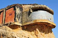
Devil's Slide was the location of a military triangulation station and observation site used during World War II as part of the harbor defense of San Francisco.[5] Prior to the advent of radar, military personnel would use binoculars and compasses to search for ships at sea and relay their coordinates to a central post. By combining information from multiple observation posts, a ship's precise location could be determined by triangulation. There were six military structures at the Devil's Slide: three concrete and steel observation pill-boxes, two concrete and earth bunkers, and a reinforced steel observation tower. The pill-boxes were used as hardened observation posts, and one of the bunkers was used as a communications and command post. The site was sold to a private owner in 1983, but some of the structures remain.
See also
Bibliography
- Biological Assessment, Species of Concern, Proposed Route 1 Devil's Slide Tunnel Bypass Project, San Mateo County, California Prepared by; Caltrans, Office of Environmental Planning, South. July, 1998.
- Michael Hogan and Ballard George, Air Quality and Noise Analyses for the Bypass Alternative, Devil's Slide Improvement Project, Caltrans District 4, prepared by Earth Metrics Inc., Burlingame, CA (1984)
- Devil's Slide Improvement Project, San Mateo County, California, Draft Second Supplemental Environmental Impact Statement, Caltrans District 4 (1999)
- Hovland, John H., Ph.D., P.E., A Study of the Feasibility of Stabilizing the Landslide Area Along Highway One, San Mateo County, California, by Dewatering, April, 1998
- Woodward-Clyde Consultants, Devil’s Slide Tunnel Study - Feasibility Report, October, 1996.
Footnotes
- ↑ Mendoza, Martha (24 February 2013). "Cutting Edge Calif. Tunnels Poised to Open". Associated Press. Retrieved 25 February 2013.
- 1 2 Is the New Devil's Slide Trail Safe? (PDF) (Report). Superior Court of California, County of San Mateo. 8 July 2014. Retrieved 23 June 2016.
- ↑ "Devil's Slide Trail". County of San Mateo Parks Department. 2016. Retrieved 23 June 2016.
- ↑ American Movie Classics, San Mateo Times
- ↑ http://www.corpsfuds.org/reports/INPR/J09CA0789inpr.pdf
External links
| Wikimedia Commons has media related to Devil's Slide (California). |
| Wikisource has original text related to this article: |
- California Coastal Commission
- Save our Bay
- Three-part series on the history of Devil's Slide
- KQED QUEST photo montage and article on tunnel
Coordinates: 37°34′28″N 122°31′13″W / 37.574383°N 122.520255°W