Dent de Combette
| Dent de Combette | |
|---|---|
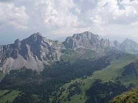 Dent de Ruth (left), Dent de Savigny (centre) and Dent de Combette (far-right) | |
| Highest point | |
| Elevation | 2,082 m (6,831 ft) |
| Prominence | 242 m (794 ft) [1] |
| Parent peak | Dent de Savigny |
| Coordinates | 46°31′39.4″N 7°12′13.6″E / 46.527611°N 7.203778°ECoordinates: 46°31′39.4″N 7°12′13.6″E / 46.527611°N 7.203778°E |
| Geography | |
 Dent de Combette Location in Switzerland | |
| Location | Vaud, Switzerland |
| Parent range | Bernese Alps |
The Dent de Combette (2,082 m) is a mountain of the western Bernese Alps, located north of Rougemont in the Swiss canton of Vaud. It lies south of the border with the canton of Fribourg, on the chain culminating at the Dent de Savigny.
A secondary summit on the south side of the mountain (2,026 m) is named Rochers des Rayes.
References
External links
This article is issued from Wikipedia - version of the 10/1/2016. The text is available under the Creative Commons Attribution/Share Alike but additional terms may apply for the media files.