Bernese Alps
| Bernese Alps | |
|---|---|
|
German: Berner Alpen French: Alpes bernoises | |
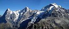
 Eiger, Mönch, and Jungfrau | |
| Highest point | |
| Peak | Finsteraarhorn |
| Elevation | 4,274 m (14,022 ft) |
| Coordinates | CH-VD, CH-FR, CH-VS_scale:100000_ 46°32′19″N 8°07′38″E / 46.53861°N 8.12722°E |
| Geography | |
 Bernese Alps (red) | |
| Country | Switzerland |
| Cantons | Bern, Vaud, Fribourg and Valais |
| Range coordinates | CH-VD, CH-FR, CH-VS_scale:300000_ 46°25′N 7°45′E / 46.42°N 7.75°ECoordinates: CH-VD, CH-FR, CH-VS_scale:300000_ 46°25′N 7°45′E / 46.42°N 7.75°E |
| Parent range | Western Alps |
| Borders on | |
| Topo map | Swiss Federal Office of Topography swisstopo |
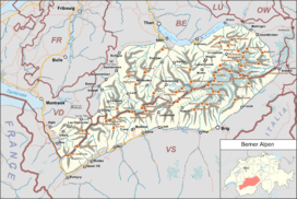
The Bernese Alps (German: Berner Alpen, French: Alpes bernoises, Italian: Alpi bernesi) are a mountain range of the Alps, located in western Switzerland. Although the name suggests that they are located in the Berner Oberland region of the canton of Bern, portions of the Bernese Alps are in the adjacent cantons of Valais, Fribourg and Vaud, the latter being usually named Fribourg Alps and Vaud Alps respectively. The highest mountain in the range, the Finsteraarhorn, is also the highest point in the canton of Bern.
The Rhône valley separates them from the Chablais Alps in the west and from the Pennine Alps in the south; the upper Rhône valley separate them from the Lepontine Alps to the southeast; the Grimsel Pass and the Aare valley separates them from the Uri Alps in the east and from the Emmental Alps in the north; their northwestern edge is not so well defined, describing a line roughly from Lake Geneva to Lake Thun.
The Bernese Alps are drained by the river Aare and its tributary the Saane in the north, the Rhône in the south, and the Reuss in the east.
Geography

One of the most considerable Alpine ranges, the Bernese Alps extend from the gorge of Saint-Maurice, through which the Rhone finds its way to Lake Geneva, to the Grimsel Pass or, depending on the definition, to the river Reuss (thus including the Uri Alps). The principal ridge, a chain that runs 100 kilometres (62 mi) from west (Dent de Morcles) to east (Sidelhorn), whose highest peak is the Finsteraarhorn, forms the watershed between the cantons of Berne and Valais. Except for the westernmost part, it is also the watershed between the Rhine (North Sea) and the Rhone (Mediterranean Sea). This chain is not centered inside the range but lies close (10 to 15 km) to the Rhone on the south. This makes a large difference between the south, where the lateral short valleys descend abruptly into the deep trench forming the valley of the Rhone and the north, where the Bernese Alps extends through a great part of the canton of Berne (Bernese Oberland), throwing out branches to the west into the adjoining cantons of Vaud and Fribourg. There the mountains progressively become lower and disappear into the hilly Swiss Plateau.[1]
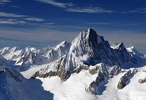
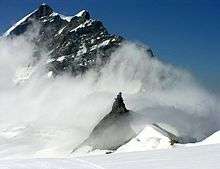
The main chain west of Gemmi Pass consists mainly of a few large prominent summits (as the Wildhorn) slightly above 3,000 metres (9,800 ft), generally covered by glaciers. On the eastern part, the main chain became suddenly wider and the peaks reach over 4,000 metres (13,000 ft), in the most glaciated part of the Alps.[2]
A characteristic in the orography of the Bernese Alps is, that whereas the western of that chain consists of a single series of summits with comparatively short projecting buttresses, the higher group presents a series of longitudinal ridges parallel to the axis of the main chain, and separated from each other by deep valleys that form the channels of great glaciers. Thus the Tschingel Glacier and the Kander Glacier, separate the portion of the main range lying between the Gemmi Pass and the Mittaghorn from the equally high parallel range of the Doldenhorn and Blümlisalp on its northern side. To the south the same portion of the main range is divided from the still higher parallel range whose summits are the Aletschhorn and the Bietschhorn by the Lötschental and the Lötschenlücke. To this again succeeds the deep trench through which the lower part of the Aletsch Glacier flows down to the Rhone, enclosed by the minor ridge that culminates at the Eggishorn.[1]
It is in the central and eastern portions of the range only that crystalline rocks make their appearance; the western part is composed almost exclusively of sedimentary deposits, and the secondary ridges extending through Berne and the adjoining cantons are formed of jurassic, cretaceous, or eocene strata.[1]
Exploration
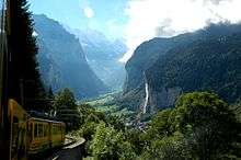
The beauty of the scenery and the facilities offered to travellers by the general extension of mountain railways make the northern side of the range, the Bernese Oberland, one of the portions of the Alps most visited by tourists. Since strangers first began to visit the Alps, the names of Grindelwald, Lauterbrunnen, and Interlaken have become famous. But unlike many other Alpine regions, which have been left to be explored by strangers, this region has been long visited by Swiss travellers and men of science. Among them were the brother Meyer of Aarau and Franz Joseph Hugi. They have explored most of the mountain ranges not very difficult of access, and, further than this, have attained most of the higher summits. In 1841, Louis Agassiz, with several scientific friends, established a temporary station on the Unteraar Glacier, and, along with scientific observations on the glaciers, started a series of expeditions. The works of Desor and Gottlieb Studer have been followed by several other publications that bear testimony to Swiss mountaineering activity. Notwithstanding the activity of their predecessors, the members of the English Alpine Club have found scope for further exploits, amongst which may be reckoned the first ascents of the Aletschhorn and the Schreckhorn, and the still more arduous enterprise of crossing the range by passes, such as the Jungfraujoch and Eigerjoch, which are considered amongst the most difficult in the Alps.[1]
Jungfrau-Aletsch area

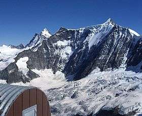
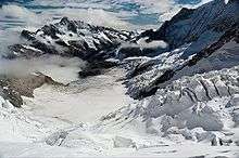
The Jungfrau-Aletsch area is located in the eastern Bernese Alps in the most glaciated region of the Alps. It was inscribed as a UNESCO World Heritage Site (Swiss Alps Jungfrau-Aletsch) in 2001 and further expanded in 2007. Its name comes from the Aletsch Glacier and the two summits of the Jungfrau and Bietschhorn, which constitute some of the most impressive features of the site. The actual site (after the extension) includes other large glacier valleys such as the Fiescher Glacier and the Aar Glaciers.
List of peaks


The chief peaks of the Bernese Alps are:
| Name | Elevation | |
|---|---|---|
| Finsteraarhorn | 4,274 m | 14,026 ft |
| Aletschhorn | 4,182 m | 13,721 ft |
| Jungfrau | 4,166 m | 13,669 ft |
| Mönch | 4,105 m | 13,468 ft |
| Schreckhorn | 4,080 m | 13,386 ft |
| Gross Fiescherhorn | 4,049 m | 13,285 ft |
| Grünhorn | 4,043 m | 13,264 ft |
| Lauteraarhorn | 4,042 m | 13,261 ft |
| Hinter Fiescherhorn | 4,025 m | 13,205 ft |
| Gletscherhorn | 3,983 m | 13,067 ft |
| Eiger | 3,970 m | 13,025 ft |
| Rottalhorn | 3,969 m | 13,031 ft |
| Ebnefluh | 3,962 m | 12,999 ft |
| Agassizhorn | 3,946 m | 12,946 ft |
| Bietschhorn | 3,934 m | 12,907 ft |
| Trugberg | 3,933 m | 12,904 ft |
| Klein Grünhorn | 3,913 m | 12,838 ft |
| Gross Wannenhorn | 3,905 m | 12,812 ft |
| Klein Fiescherhorn | 3,895 m | 13,779 ft |
| Mittaghorn | 3,892 m | 12,769 ft |
| Fiescher Gabelhorn | 3,876 m | 12,717 ft |
| Schönbühlhorn | 3,854 m | 12,644 ft |
| Nesthorn | 3,820 m | 12,533 ft |
| Dreieckhorn | 3,811 m | 12,503 ft |
| Schinhorn | 3,797 m | 12,457 ft |
| Breithorn (Blatten) | 3,785 m | 12,418 ft |
| Breithorn (Lauterbrunnen) | 3,779 m | 12,399 ft |
| Grosshorn | 3,754 m | 12,316 ft |
| Sattelhorn | 3,745 m | 12,287 ft |
| Kranzberg | 3,742 m | 12,277 ft |
| Geisshorn | 3,740 m | 12,270 ft |
| Klein Lauteraarhorn | 3,737 m | 12,260 ft |
| Wetterhorn | 3,708 m | 12,166 ft |
| Mittelhorn | 3,704 m | 12,152 ft |
| Rotstock | 3,699 m | 12,136 ft |
| Balmhorn | 3,698 m | 12,133 ft |
| Silberhorn | 3,695 m | 12,122 ft |
| Rosenhorn | 3,689 m | 12,103 ft |
| Blüemlisalphorn | 3,671 m | 12,044 ft |
| Bärglistock | 3,656 m | 11,995 ft |
| Breitlauihorn | 3,655 m | 11,991 ft |
| Doldenhorn | 3,647 m | 11,966 ft |
| Hugihorn | 3,647 m | 11,965 ft |
| Altels | 3,636 m | 11,930 ft |
| Gross Fusshorn | 3,627 m | 11,900 ft |
| Tschingelhorn | 3,562 m | 11,686 ft |
| Lonzahörner | 3,560 m | 11,680 ft |
| Unterbächhorn | 3,554 m | 11,660 ft |
| Finsteraarrothorn | 3,530 m | 11,580 ft |
| Galmihorn | 3,505 m | 11,499 ft |
| Wysshorn | 3,546 m | 11,634 ft |
| Kleines Schreckhorn | 3,494 m | 11,463 ft |
| Nasse Strahlegg | 3,485 m | 11,434 ft |
| Lauteraar Rothörner | 3,478 m | 11,411 ft |
| Wasenhorn | 3,447 m | 11,309 ft |
| Gspaltenhorn | 3,442 m | 11,293 ft |
| Ewigschneehorn | 3,331 m | 10,929 ft |
| Olmenhorn | 3,314 m | 10,873 ft |
| Hienderstock | 3,307 m | 10,849 ft |
| Wilerhorn | 3,307 m | 10,850 ft |
| Tschingelspitz | 3,304 m | 10,840 ft |
| Hockenhorn | 3,293 m | 10,804 ft |
| Ritzlihorn | 3,282 m | 10,768 ft |
| Hogleifa | 3,278 m | 10,755 ft |
| Wildhorn | 3,248 m | 10,656 ft |
| Bächlistock | 3,247 m | 10,653 ft |
| Birghorn | 3,243 m | 10,640 ft |
| Wildstrubel | 3,243 m | 10,640 ft |
| Hohstock | 3,226 m | 10,584 ft |
| Stockhorn | 3,212 m | 10,538 ft |
| Diablerets | 3,210 m | 10,650 ft |
| Sackhorn | 3,204 m | 10,512 ft |
| Petersgrat | 3,202 m | 10,505 ft |
| Strahlhorn (Baltschieder) | 3,200 m | 10,500 ft |
| Wellhorn | 3,196 m | 10,486 ft |
| Wannihorn | 3,115 m | 10,220 ft |
| Brandlammhorn | 3,108 m | 10,197 ft |
| Mettenberg | 3,107 m | 10,194 ft |
| Schwarzhorn | 3,105 m | 10,187 ft |
| Löffelhorn | 3,098 m | 10,165 ft |
| Geltenhorn | 3,065 m | 10,056 ft |
| Grand Muveran | 3,061 m | 10,043 ft |
| Mutthorn | 3,053 m | 9,957 ft |
| Arpelistock | 3,035 m | 9,957 ft |
| Sparrhorn | 3,026 m | 9,928 ft |
| Torrenthorn | 3,003 m | 9,853 ft |
| Wiwannihorn | 3,001 m | 9,846 ft |
| Schilthorn | 2,973 m | 9,754 ft |
| Dent de Morcles | 2,969 m | 9,741 ft |
| Gärsthorn | 2,964 m | 9,724 ft |
| Eggishorn | 2,934 m | 9,626 ft |
| Schwarzhorn | 2,930 m | 9,613 ft |
| Gross Sidelhorn | 2,881 m | 9,452 ft |
| Alplistock | 2,878 m | 9,442 ft |
| Risihorn | 2,876 m | 9,436 ft |
| Bettmerhorn | 2,872 m | 9,423 ft |
| Gstellihorn | 2,855 m | 9,367 ft |
| Grosses Engelhorn | 2,782 m | 9,127 ft |
| Chistehorn | 2,785 m | 9,137 ft |
| Albristhorn | 2,764 m | 9,069 ft |
| Bietenhorn | 2,756 m | 9,042 ft |
| Ärmighorn | 2,742 m | 8,996 ft |
| Klein Wellhorn | 2,701 m | 8,862 ft |
| Birg | 2,684 m | 8,806 ft |
| Faulhorn | 2,683 m | 8,803 ft |
| Sulegg | 2,412 m | 7,914 ft |
| Niesen | 2,366 m | 7,763 ft |
| Regenboldshorn | 2,193 m | 7,195 ft |
| Le Chamossaire | 2,116 m | 6,943 ft |
Glaciers
Main glaciers:
- Aletsch Glacier
- Fiescher Glacier
- Unteraar Glacier
- Lower Grindelwald Glacier
- Oberaletsch Glacier
- Mittelaletsch Glacier
- Gauli Glacier
- Lang Glacier
- Upper Grindelwald Glacier
- Kander Glacier
- Tschingel Glacier
- Rosenlaui Glacier
- Plaine Morte Glacier
- Wildstrubel Glacier
- Tsanfleuron Glacier
- Diablerets Glacier
List of passes
The chief passes of the Bernese Alps are:
| Mountain pass | Location | Type | Elevation | |
|---|---|---|---|---|
| Lauitor | Lauterbrunnen to the Eggishorn | Snow | 3,700 m | 12,140 ft |
| Mönchjoch | Grindelwald to the Eggishorn | Snow | 3,560 m | 11,680 ft |
| Jungfraujoch | Wengernalp to the Eggishorn | Snow | 3,470 m | 11,385 ft |
| Strahlegg | Grindelwald to the Grimsel Pass | Snow | 3,351 m | 10,995 ft |
| Grünhornlücke | Great Aletsch Glacier to the Fiescher Glacier | Snow | 3,305 m | 10,844 ft |
| Oberaarjoch | Grimsel to the Eggishorn | Snow | 3,233 m | 10,607 ft |
| Gauli | Grimsel to Meiringen | Snow | 3,206 m | 10,519 ft |
| Petersgrat | Lauterbrunnen to the Lötschental | Snow | 3,205 m | 10,516 ft |
| Lötschenlücke | Lötschental to the Eggishorn | Snow | 3,204 m | 10,512 ft |
| Lauteraarsattel | Grindelwald to the Grimsel | Snow | 3,156 m | 10,355 ft |
| Beichgrat | Lötschental to the Belalp | Snow | 3,136 m | 10,289 ft |
| Lammernjoch | Lenk to the Gemmi | Snow | 3,132 m | 10,276 ft |
| Gamchilucke | Kiental to Lauterbrunnen | Snow | 2,833 m | 9,295 ft |
| Tschiugel | Lauterbrunnen to Kandersteg | Snow | 2,824 m | 9,265 ft |
| Hohtürli | Kandersteg to the Kiental | Footpath | 2,707 m | 8,882 ft |
| Lötschen | Kandersteg to the Lötschental | Snow | 2,695 m | 8,842 ft |
| Sefinenfurgge | Lauterbrunnen to the Kiental | Footpath | 2,616 m | 8,583 ft |
| Rawil | Sion to Lenk im Simmental | Bridle path | 2,415 m | 7,924 ft |
| Gemmi | Kandersteg to Leukerbad | Bridle path | 2,329 m | 7,641 ft |
| Sanetsch | Sion to Saanen | Bridle path | 2,234 m | 7,331 ft |
| Grimsel | Meiringen to the Rhone Glacier | Road | 2,164 m | 7,100 ft |
| Kleine Scheidegg | Grindelwald to Lauterbrunnen | Path, railway | 2,064 m | 6,772 ft |
| Cheville | Sion to Bex | Bridle path | 2,049 m | 6,723 ft |
| Grosse Scheidegg | Grindelwald to Meiringen | Bridle path | 1,967 m | 6,454 ft |
See also
- Bernese Alps in the wide sense
- Swiss Alps
- The Alps (documentary film)
References
External links
| Wikimedia Commons has media related to Bernese Alps. |