Denali Fault
The Denali Fault is a major intracontinental dextral (right lateral) strike-slip fault in western North America, extending from northwestern British Columbia, Canada to the central region of the U.S. state of Alaska.[1]
Location
The Denali Fault is located in Alaska's Denali National Park and to the east. This National Park includes part of a massive mountain range more than 600 miles long. Along the Denali Fault, lateral and vertical offset movement is taking place (as evidenced by many earthquakes in the region).
The steep north face of Denali, known as the Wickersham Wall, rises 15000 feet from its base, and is a result of this relatively recent movement.
Effects
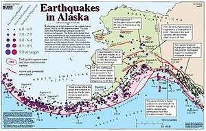
Alaska’s network of faults is a result of tectonic activity; the Pacific Plate is actively subducting (sliding under) the North American Plate, and the Denali Fault is located on the boundary between the two plates.[2] The fault's rate of displacement varies from 1 mm to 35 mm per year.[3]
It was the main fault along which the 2002 Denali earthquake occurred, which was measured as a magnitude of 7.9 Mw.[4] During the afternoon of November 3, 2002, the water in Seattle’s Lake Union suddenly began sloshing hard enough to knock houseboats off their moorings. Water in pools, ponds, and bayous as far away as Texas and Louisiana splashed for nearly half an hour.
The earthquake began at 1:12 p.m. Alaska local time, and was centered approximately 135 kilometers (84 miles) south of Fairbanks and 283 kilometers (176 miles) north of Anchorage. Shaking at the epicenter lasted approximately 1.5 to 2 minutes, but in Fairbanks the duration of the earthquake was over 3 minutes.
Originating on the previously unknown Susitna Glacier Fault, the earthquake shot eastward along the well-known Denali Fault at a speed of over 11,265 kilometers (7,000 miles) per hour before branching southeast onto the Totschunda Fault. The resulting surface rupture was approximately 336 kilometers (209 miles) long, and it cut through streams, divided forests, opened chasms in roads, and even generated fault traces visible across several glaciers. Because the earthquake released most of its energy on the sparsely populated eastern end of the fault, Alaska’s major cities were spared serious damage.[2]
See also
References
- ↑ Benjamin R. Edwards, James K. Russell (August 2000). "Distribution, nature, and origin of Neogene–Quaternary magmatism in the northern Cordilleran volcanic province, Canada" (PDF). Geological Society of America Bulletin. Geological Society of America: 1280–1295. Bibcode:2000GSAB..112.1280E. doi:10.1130/0016-7606(2000)112<1280:dnaoon>2.0.co;2.
- 1 2 Laura Naranjo (November 13, 2003). "Denali's Fault". NASA. Retrieved May 20, 2012.
- ↑ Mark Yashinsky, ed. (2004). Denali, Alaska, Earthquake of November 3, 2002. Reston, VA: ASCE, TCLEE. ISBN 9780784407479.
- ↑ Eberhart-Phillips, Donna; Haeussler, Peter J.; Freymueller, Jeffrey T.; Frankel, Arthur D.; Rubin, Charles M.; Craw, Patricia; Ratchkovski, Natalia A.; Anderson, Greg; Carver, Gary A; et al. (May 2003). "The 2002 Denali Fault Earthquake, Alaska: A Large Magnitude, Slip-Partitioned Event". Science. Elsevier. 300 (5622, number 5622): 1113–1118. Bibcode:2003Sci...300.1113E. doi:10.1126/science.1082703.