Delaware Route 72
| ||||
|---|---|---|---|---|
 | ||||
| Route information | ||||
| Maintained by DelDOT | ||||
| Length: | 17.35 mi[1] (27.92 km) | |||
| Existed: | 1942[2] – present | |||
| Major junctions | ||||
| South end: |
| |||
|
| ||||
| North end: |
| |||
| Location | ||||
| Counties: | New Castle | |||
| Highway system | ||||
| ||||

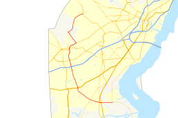
Delaware Route 72 (DE 72) is a state highway located in New Castle County, Delaware. The route runs from DE 9 near Delaware City north to DE 7 in Pike Creek. The route runs through suburban areas of northern New Castle County, passing through the eastern part of Newark. DE 72 intersects U.S. Route 13 (US 13), DE 1, and DE 7 near Delaware City, DE 71 near Kirkwood, US 40 east of Glasgow, and DE 2, DE 4, and DE 273 in Newark. Parts of DE 72 were built as a state highway during the 1930s. By the 1940s, the route was designated between DE 2 in Newark and DE 7 in Pike Creek along Paper Mill Road. The route was extended south to DE 9 in the 1960s. In 1980, the alignment was shifted to the east through Newark to bypass a railroad crossing on Chapel Street.
Route description
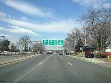
DE 72 begins at an intersection with DE 9 adjacent to the Delaware City Refinery near Delaware City, heading west on two-lane undivided Wrangle Hill Road. The road continues between the oil refinery to the north and farmland to the south before coming to an intersection with US 13 and the southern terminus of DE 7 in Wrangle Hill, where it widens into a four-lane divided highway. At this point, US 13 turns west for a short concurrency with DE 72 to a diverging diamond interchange with the DE 1 freeway, where US 13 splits north onto DE 1.[3][4]
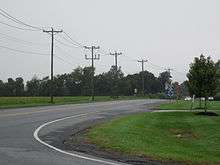
Past this interchange, DE 72 narrows back into a two-lane undivided road and passes through a mix of farmland and residences, coming to an intersection with DE 71. Following this, the road curves to the northwest through a mix of homes and commercial establishments, crossing Norfolk Southern's Delmarva Secondary railroad line. The route curves north and comes to an intersection with US 40 in a commercial area to the east of Glasgow.[3][4]
Past the US 40 intersection, DE 72 continues to the north on Sunset Lake Road, heading into wooded areas with some fields and residential development and closely running to the west of a Norfolk Southern line. The route crosses to the east side of the railroad tracks and widens into a five-lane road with a center left-turn lane as it comes to an intersection with Old Baltimore Pike. At this intersection, the route name changes to South Chapel Street and it passes through fields with some development, crossing under Interstate 95 (I-95, Delaware Turnpike) without an interchange. DE 72 enters the eastern part of Newark and passes industrial parks before heading past businesses and residential neighborhoods as it comes to an intersection with DE 4.[3][4]
Following this intersection, the road narrows to two lanes as it heads through agricultural areas to the east of the University of Delaware campus. The route continues northeast onto Library Avenue and runs through woods as it comes to a bridge over Amtrak's Northeast Corridor railroad line. The road bends north into commercial areas, passing to the east of Newark High School and widening into a four-lane divided highway as it comes to an intersection with Delaware Avenue, which carries the eastbound direction of DE 273. Here, eastbound DE 273 turns north to join DE 72 and the road reaches an intersection where westbound DE 273 runs west on Main Street and DE 273 continues east as Ogletown Road. Past this intersection, DE 72 becomes concurrent with DE 2 and the name changes to Capitol Trail as it turns northeast and passes under CSX's Philadelphia Subdivision railroad line. The road leaves Newark and heads northeast through residential areas, briefly becoming undivided as it crosses White Clay Creek.[3][4]
DE 72 splits from DE 2 by heading northwest on two-lane undivided Possum Park Road through a mix of fields, woods, and housing developments. In Milford Crossroads, the route turns northeast onto Paper Mill Road and curves north to pass between White Clay Creek State Park to the west and the Middle Run Valley Natural Area to the east. The road continues northeast into the suburban Pike Creek area. DE 72 turns east and reaches its northern terminus at another intersection with DE 7.[3][4]
DE 72 has an annual average daily traffic count ranging from a high of 34,091 vehicles at the north end of Newark to a low of 3,489 vehicles at the US 13 intersection.[1] The portions of DE 72 concurrent with US 13 and DE 2 are part of the National Highway System.[5]
History
What is now DE 72 originally existed as a county road by 1920.[6] By 1931, the road was proposed as a state highway between present-day DE 9 and US 13 while what would become DE 72 north of Milford Crossroads was completed as a state highway.[7] The road from present-day DE 9 to US 13 became a state highway a year later.[8] On July 1, 1935, the remaining sections of the present-day route were transferred from the county to the state.[9][10] The portion of the road between US 13 and US 40 was improved by the state in 1937, providing a better route to Baltimore and Washington, D.C. for residents in the Delaware City, Port Penn, and Odessa areas.[11]
DE 72 was designated by 1942 to run from DE 2 in Newark north to DE 7, following Chapel Street and Paper Mill Road.[2] In 1939, suggestions were made to replace the bridge over the White Clay Creek along Paper Mill Road in Newark.[12] Plans were completed for this bridge by 1942 but construction was postponed due to World War II.[13] The concrete bridge carrying Paper Mill Road over the White Clay Creek was completed in 1947, with final work on the project finished in August 1949.[14][15] By 1954, Sunset Lake Road was improved from a dirt road to a low-type bituminous road.[16] The roadway between US 40 and Newark was paved by 1966.[17]
DE 72 was extended to its present southern terminus at DE 9 the next year, following Chapel Street, Sunset Lake Road, and Wrangle Hill Road.[18] In 1980, the Chapel Street crossing of the Northeast Corridor rail line in Newark was removed, and DE 72 was realigned farther to the east to follow Library Avenue across the railroad tracks before continuing north on DE 2 and Possum Park Road to Paper Mill Road in Milford Crossroads.[19] DE 2 was realigned to follow DE 72 around the eastern part of Newark on Library Avenue by 1990.[20] In 2013, the DE 2 concurrency between DE 4 and DE 273 was removed due to the truncation of DE 2 to the DE 273 intersection.[21] On April 29, 2016, Governor Jack Markell, DelDOT secretary Jennifer Cohan, and local officials attended a groundbreaking ceremony for a $7 million project that rebuilt the interchange with DE 1 into a diverging diamond interchange, the first such interchange in Delaware.[22] The diverging diamond interchange configuration was put into place on November 19, 2016.[23]
Major intersections
The entire route is in New Castle County.
| Location | mi[1] | km | Destinations | Notes | |
|---|---|---|---|---|---|
| Delaware City | 0.00 | 0.00 | Southern terminus | ||
| Wrangle Hill | 1.50 | 2.41 | South end of US 13 overlap | ||
| DE 1 exit 152, north end of US 13 overlap | |||||
| Williamsburg | 2.98 | 4.80 | |||
| Glasgow | 5.35 | 8.61 | |||
| Newark | 9.22 | 14.84 | |||
| 10.65 | 17.14 | South end of DE 273 eastbound overlap | |||
| 10.85 | 17.46 | North end of DE 273 eastbound overlap, south end of DE 2 overlap | |||
| 12.06 | 19.41 | North end of DE 2 overlap | |||
| Pike Creek | 17.35 | 27.92 | Northern terminus | ||
1.000 mi = 1.609 km; 1.000 km = 0.621 mi
| |||||
See also
 U.S. Roads portal
 Delaware portal
References
- 1 2 3 Staff (2011). "Traffic Count and Mileage Report: Interstate, Delaware, and US Routes" (PDF). Delaware Department of Transportation. Retrieved May 17, 2012.
- 1 2 Delaware State Highway Department (1942). Official Road Map of the State of Delaware (PDF) (Map). Dover: Delaware State Highway Department. Retrieved November 24, 2015.
- 1 2 3 4 5 Delaware Department of Transportation (2008). Delaware Official Transportation Map (PDF) (Map). Dover: Delaware Department of Transportation. Retrieved November 24, 2015.
- 1 2 3 4 5 Google (February 6, 2011). "overview of Delaware Route 72" (Map). Google Maps. Google. Retrieved February 6, 2011.
- ↑ National Highway System: Delaware (PDF) (Map). Federal Highway Administration. 2010. Retrieved February 10, 2012.
- ↑ Delaware State Highway Department (1920). Official Road Map (PDF) (Map). Dover: Delaware State Highway Department. Retrieved November 24, 2015.
- ↑ Delaware State Highway Department (1931). Official Road Map of the State of Delaware (PDF) (Map). Dover: Delaware State Highway Department. Retrieved November 24, 2015.
- ↑ Delaware State Highway Department (1932). Official Road Map (PDF) (Map). Dover: Delaware State Highway Department. Retrieved November 24, 2015.
- ↑ "Annual Report of the State Highway Department of the State of Delaware" (PDF) (1935 ed.). Dover, DE: Delaware State Highway Department. January 7, 1936: 7. Retrieved November 19, 2014.
- ↑ Delaware State Highway Department; The National Survey Co. (1936). Official Road Map of the State of Delaware (PDF) (Map) (1936–37 ed.). Dover: Delaware State Highway Department. Retrieved November 24, 2015.
- ↑ "Annual Report of the State Highway Department" (PDF) (1937 ed.). Dover, Delaware: Delaware State Highway Department. January 1, 1938: 19. Retrieved November 13, 2014.
- ↑ "Annual Report of the State Highway Department" (PDF) (1939 ed.). Dover, Delaware: Delaware State Highway Department. January 1, 1940: 41. Retrieved November 21, 2014.
- ↑ "Annual Report of the State Highway Department" (PDF) (1941-42 ed.). Dover, Delaware: Delaware State Highway Department. July 1, 1942: 35. Retrieved November 21, 2014.
- ↑ Federal Highway Administration (2012). "NBI Structure Number: 1231 013". National Bridge Inventory. Federal Highway Administration.
- ↑ "Report of the State Highway Department" (PDF) (1950 ed.). Dover, Delaware: Delaware State Highway Department. July 1, 1950: 34. Retrieved November 21, 2014.
- ↑ Delaware State Highway Department (1954). Official Highway Map of Delaware (PDF) (Map) (1954–55 ed.). Dover: Delaware State Highway Department. Retrieved November 24, 2015.
- ↑ Delaware State Highway Department (1966). Official Highway Map (PDF) (Map). Dover: Delaware State Highway Department. Retrieved November 24, 2015.
- ↑ Delaware State Highway Department (1967). Official Highway Map (PDF) (Map). Dover: Delaware State Highway Department. Retrieved November 24, 2015.
- ↑ Delaware Department of Transportation (1981). Delaware Official State Highway Map (PDF) (Map). Dover: Delaware Department of Transportation. Retrieved November 24, 2015.
- ↑ Delaware Department of Transportation (1990). Official State Map (PDF) (Map). Dover: Delaware Department of Transportation. Retrieved November 24, 2015.
- ↑ Shannon, Josh (July 1, 2013). "A route to less clutter: DelDOT to consolidate Newark route numbers". Newark Post. Retrieved August 15, 2013.
- ↑ "Start of Construction for Delaware's First Diverging Diamond Interchange Celebrated by State and Local Officials" (Press release). Delaware Department of Transportation. April 29, 2016. Retrieved May 2, 2016.
- ↑ "Traffic Pattern Activiated for the New Diverging Diamond Interchange at State Route 1 and Route 72" (Press release). Delaware Department of Transportation. November 18, 2016. Retrieved November 21, 2016.
External links
 Media related to Delaware Route 72 at Wikimedia Commons