U.S. Route 40 in Delaware
| ||||
|---|---|---|---|---|
_map.svg.png) | ||||
| Route information | ||||
| Maintained by DelDOT and DRBA | ||||
| Length: | 17.18 mi[1] (27.65 km) | |||
| Existed: | 1926[2] – present | |||
| Major junctions | ||||
| West end: |
| |||
|
| ||||
| East end: |
| |||
| Location | ||||
| Counties: | New Castle | |||
| Highway system | ||||
| ||||

U.S. Route 40 (US 40) is a US highway running from Park City, Utah east to Atlantic City, New Jersey. In the US state of Delaware, it serves as a major east–west highway in northern New Castle County, just south of Wilmington. It runs from the Maryland border east of Elkton, Maryland east to the Delaware Memorial Bridge over the Delaware River to New Jersey, at which point it is concurrent with Interstate 295 (I-295). Along the way, US 40 runs through suburban areas of Glasgow and Bear before following US 13 and I-295 around New Castle. US 40 is a multilane divided highway the entire length across Delaware.
US 40 was originally built as a state highway during the 1920s, comprising Elkton Road and a part of the Dupont Highway. When first designated, the route followed these two roads to Wilmington, where it crossed the Delaware River on a ferry to Penns Grove, New Jersey. By the 1930s, the route was rerouted at Hares Corner to head east into New Castle and cross the river on a ferry to Pennsville, New Jersey. Also, the entire length of US 40 west of Hares Corner was widened to a divided highway during the 1930s. The Delaware Memorial Bridge opened in 1951, and US 40 was rerouted up US 13 to the bridge approach, with Delaware Route 273 (DE 273) being extended along the former route into New Castle. In 1959, the Delaware Memorial Bridge approach became a part of I-295. Between the 1960s and 1990s, US 301 ran along the US 13/US 40 concurrency and US 301N followed US 40 between Glasgow and State Road from the 1970s to the 1980s.
Route description
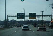
US 40 enters Delaware from Maryland west of Glasgow, heading east on the four-lane divided Pulaski Highway. From the state line, the route passes near residential subdivisions. Upon reaching Glasgow, the road continues into commercial areas and the median of the road widens to include businesses in it. US 40 comes to an intersection with DE 896 Bus. in the center of the community. The median of the road narrows as it reaches an intersection with the northern terminus of US 301 and DE 896 on the eastern edge of Glasgow. Past this intersection, the route runs between Glasgow Park to the north and commercial areas to the south. US 40 passes through residential and business areas and comes to an intersection with DE 72. Past this intersection, the road curves to the northeast, crossing Norfolk Southern's Delmarva Secondary railroad line. The route passes through wooded areas with some development as it enters Bear. US 40 continues through suburban areas, coming to an intersection with DE 7.[3][4]
Past this intersection, the road comes to an interchange with the DE 1 freeway. After this interchange, the route passes more development and some farm fields. Farther east, US 40 heads through business areas immediately to the north of Norfolk Southern's New Castle Secondary railroad line as it reaches a directional intersection with US 13 in State Road.[3][4]
At this point, US 40 heads northeast for a concurrency with US 13 on South Dupont Highway, an eight-lane divided highway. The road runs through commercial areas, coming to an intersection with DE 273 in Hares Corner. Past this intersection, US 13/US 40 passes between Wilmington Airport to the northwest and businesses to the southeast as North Dupont Highway, reaching a cloverleaf interchange with the southern terminus of US 202 and DE 141 at the end of the airport property. Following this, the two routes narrow to six lanes, passing to the northwest of Wilmington University and heading through Wilmington Manor before reaching an interchange with I-295 (Delaware Turnpike).[3][4]
Here, US 40 splits from US 13 by heading east along with I-295 on an eight-lane freeway maintained by the Delaware River and Bay Authority (DRBA). The road has an eastbound ramp to Landers Lane before it passes between residential neighborhoods and has an interchange with DE 9 north of New Castle. This interchange provides access to Veterans Memorial Park, where a war memorial honoring veterans from Delaware and New Jersey is located. Past DE 9, the median of the freeway widens to include the DRBA headquarters, with direct access to and from the westbound lanes while eastbound access is provided by way of DE 9. After this, the westbound direction comes to a toll plaza for the Delaware Memorial Bridge. I-295/US 40 continues east and passes over Norfolk Southern's New Castle Secondary before crossing the Delaware River on the twin-span Delaware Memorial Bridge, at which point both routes head into New Jersey.[3][4]
US 40 in Delaware has an annual average daily traffic count ranging from a high of 92,113 vehicles at the DE 9 interchange to a low of 28,768 vehicles at the DE 896 Bus. intersection.[1] The entire length of US 40 in Delaware is part of the National Highway System.[5]
History

By 1920, what would become the Delaware portion of US 40 was a county road, with the portion along US 13 under contract to become a state highway.[6] The portion of US 40 along the Dupont Highway was completed by 1923.[7] The Pulaski Highway portion of the road was built as a state highway by 1924.[8] When the US Highway System was created in 1926, US 40 was designated to pass through Delaware along Elkton Road (Pulaski Highway) between the Maryland border and State Road, US 13 from State Road to Wilmington, and Christiana Avenue from US 13 to a ferry across the Delaware River which carried the route to Penns Grove, New Jersey.[2][9] In 1926, the Delaware State Highway Department suggested that the portion of US 40 that followed US 13 along the DuPont Highway be widended.[10] This widening was completed a year later.[11] By 1931, US 40 was rerouted at Hares Corner to head east through New Castle and cross the Delaware River on a ferry to Pennsville, New Jersey. All of the route was a state highway by this time except the portion from Hares Corner to Basin Road.[12]
In 1931, work began on widening US 40 along the US 13 concurrency to a divided highway.[13] The completion of the divided highway between State Road and Wilmington was slated for summer 1933.[14] Recommendations were made in 1932 to widen US 40 into a divided highway between the Maryland border and State Road.[14] A year later, the divided highway portion of US 40 had been graded between the Maryland border and Glasgow while paving of the divided highway was in progress between Bear and State Road.[15] Grading of the divided highway between the Maryland border and State Road had been completed in 1934 with construction of the remainder of the road underway.[16] Work on widening US 40 to a divided highway between the Maryland border and US 13 was finished in 1936.[17] In 1934, recommendations were made to upgrade US 40 to a state highway between Hares Corner and New Castle.[16] The portion of US 40 between Hares Corner and New Castle was taken over by the state on July 1, 1935.[18][19] Construction on upgrading this section began in 1936.[17] This project was completed later that year.[19] The same year, a bridge was constructed over a Pennsylvania Railroad line (now the New Castle Industrial Track Trail) in New Castle.[17]
Construction on the Delaware Memorial Bridge began in 1949.[20] At the same time, work was underway on the Delaware Memorial Bridge approach, a divided highway which would begin at a directional-T interchange with US 13 in Farnhurst and head east to a cloverleaf interchange at New Castle Avenue (present DE 9) before leading to the bridge.[21][22] Construction on the US 13 interchange at Farnhurst began on July 12, 1950.[23] On August 16, 1951, the Delaware Memorial Bridge opened to traffic.[24] US 40 was rerouted to use the new Delaware Memorial Bridge to cross the Delaware River, being realigned to follow US 13 north from Hares Corner and Farnhurst and the bridge approach road between Farnhurst and the bridge. The ferry connecting New Castle to Pennsville was discontinued and DE 273 was extended along the former alignment of US 40 into New Castle.[25]
In 1954, plans were made to replace the intersection with DE 41/DE 141 in Basin Corner with a modified cloverleaf interchange in an effort to reduce traffic congestion.[26] Construction on the interchange began in September of that year.[27] The interchange between US 13/US 40 and DE 41/DE 141 was completed in 1956.[22][28] In 1958, construction began for a bridge at the Farnhurst interchange that would link the US 40 approach to the Delaware Memorial Bridge to the Delaware Turnpike that was proposed to run west to the Maryland border.[29] A year later, the Farnhurst interchange and the bridge approach were upgraded to Interstate Highway standards, and it was designated as part of I-295.[30][31] Construction at the interchange connecting to the Delaware Turnpike at Farnhurst was completed in July 1961. On November 14, 1963, the Delaware Turnpike opened to traffic, with I-295 extended west along that road to I-95.[32][33] In the middle of 1964, work began on a second span at the Delaware Memorial Bridge due to increasing traffic volumes. The second span of the bridge was opened to traffic in fall 1968.[34][35]
By 1966, US 301 was designated along the US 13/US 40 concurrency.[36] US 301N was designated to follow US 40 between DE 896 and US 13 in 1971.[37][38] US 301N was removed from US 40 in 1985.[39][40] By 1994, US 301 was removed from the US 13/US 40 concurrency, having been rerouted to follow DE 896 to end at US 40 in Glasgow.[41]
Major intersections
| County | Location | mi[1] | km | Destinations | Notes |
|---|---|---|---|---|---|
| New Castle | Glasgow | 0.00 | 0.00 | Maryland state line | |
| 2.12 | 3.41 | ||||
| 2.33 | 3.75 | ||||
| 3.70 | 5.95 | ||||
| Bear | 7.15 | 11.51 | |||
| DE 1 exit 160 | |||||
| State Road | 9.84 | 15.84 | West end of US 13/DE 9 Truck overlap | ||
| Hares Corner | 10.88 | 17.51 | East end of DE 9 Truck overlap | ||
| Wilmington Manor | 12.11 | 19.49 | US 202/DE 141 exit 1 | ||
| 13.40 | 21.57 | Interchange, east end of US 13 overlap, west end of I-295 overlap | |||
| West end of freeway section | |||||
| Landers Lane | Eastbound exit | ||||
| Holloway Terrace | 14.67 | 23.61 | Access to Veterans Memorial Park and Delaware River and Bay Authority Headquarters | ||
| Delaware River and Bay Authority Headquarters | Westbound exit and entrance, eastbound access provided by DE 9 | ||||
| Delaware River | 17.18 | 27.65 | Delaware Memorial Bridge (Westbound toll, cash or E-ZPass) | ||
| Salem | Pennsville Township | 17.18 | 27.65 | New Jersey state line | |
1.000 mi = 1.609 km; 1.000 km = 0.621 mi
| |||||
See also
-
 U.S. Roads portal
 -
 Delaware portal
References
- 1 2 3 Staff (2011). "Traffic Count and Mileage Report: Interstate, Delaware, and US Routes" (PDF). Delaware Department of Transportation. Retrieved May 17, 2012.
- 1 2 Bureau of Public Roads & American Association of State Highway Officials (November 11, 1926). United States System of Highways Adopted for Uniform Marking by the American Association of State Highway Officials (Map). 1:7,000,000. Washington, DC: U.S. Geological Survey. OCLC 32889555. Retrieved November 7, 2013 – via University of North Texas Libraries.
- 1 2 3 4 Delaware Department of Transportation (2008). Delaware Official Transportation Map (PDF) (Map). Dover: Delaware Department of Transportation. Retrieved November 24, 2015.
- 1 2 3 4 Google (February 9, 2011). "overview of U.S. Route 40 in Delaware" (Map). Google Maps. Google. Retrieved February 9, 2011.
- ↑ National Highway System: Delaware (PDF) (Map). Federal Highway Administration. 2010. Retrieved February 10, 2012.
- ↑ Delaware State Highway Department (1920). Official Road Map (PDF) (Map). Dover: Delaware State Highway Department. Retrieved November 24, 2015.
- ↑ John Milner Associates, Inc. (July 2005). Historic Context for the DuPont Highway U.S. Route 113: Kent and Sussex County, Delaware (PDF). in association with Whitman, Requardt, Inc. and Rummel, Klepper & Kahl, LLP. Dover, DE: Delaware Department of Transportation. p. 16. Retrieved January 29, 2014.
- ↑ Delaware State Highway Department (1924). Official Road Map (PDF) (Map). Dover: Delaware State Highway Department. Retrieved November 24, 2015.
- ↑ Map of New Jersey (Map). Tydol Trails. 1927. Retrieved February 9, 2011.
- ↑ "Delaware State Highway Department Report" (PDF) (1926 ed.). Dover, Delaware: Delaware State Highway Department. December 31, 1926: 38. Retrieved January 30, 2014.
- ↑ "Annual Report of the State Highway Department" (PDF) (1927 ed.). Dover, Delaware: Delaware State Highway Department. December 31, 1927: 7-8. Retrieved January 30, 2014.
- ↑ Delaware State Highway Department (1931). Official Road Map of the State of Delaware (PDF) (Map). Dover: Delaware State Highway Department. Retrieved November 24, 2015.
- ↑ "Annual Report of the State Highway Department" (PDF) (1931 ed.). Dover, Delaware: Delaware State Highway Department. December 31, 1931: 41. Retrieved January 30, 2014.
- 1 2 "Annual Report of the State Highway Department" (PDF) (1932 ed.). Dover, Delaware: Delaware State Highway Department. December 31, 1932: 31, 33. Retrieved January 30, 2014.
- ↑ "Annual Report of the State Highway Department" (PDF) (1933 ed.). Dover, Delaware: Delaware State Highway Department. January 1, 1934: 38. Retrieved November 10, 2014.
- 1 2 "Annual Report of the State Highway Department" (PDF) (1934 ed.). Dover, Delaware: Delaware State Highway Department. January 1, 1935: 37, 68. Retrieved November 10, 2014.
- 1 2 3 "Annual Report of the State Highway Department" (PDF) (1936 ed.). Dover, Delaware: Delaware State Highway Department. January 20, 1937: 19-21. Retrieved November 10, 2014.
- ↑ "Annual Report of the State Highway Department of the State of Delaware" (PDF) (1935 ed.). Dover, DE: Delaware State Highway Department. January 7, 1936: 7. Retrieved November 19, 2014.
- 1 2 Delaware State Highway Department; The National Survey Co. (1936). Official Road Map of the State of Delaware (PDF) (Map) (1936–37 ed.). Dover: Delaware State Highway Department. Retrieved November 24, 2015.
- ↑ "Report of the State Highway Department" (PDF) (1950 ed.). Dover, Delaware: Delaware State Highway Department. July 1, 1950: 73. Retrieved November 10, 2014.
- ↑ "Report of the State Highway Department" (PDF) (1950 ed.). Dover, Delaware: Delaware State Highway Department. July 1, 1950: 51. Retrieved November 10, 2014.
- 1 2 Delaware State Highway Department (1957). Official Highway Map of Delaware (PDF) (Map) (1957–58 ed.). Dover: Delaware State Highway Department. Retrieved November 24, 2015.
- ↑ "Report of the State Highway Department" (PDF) (1951 ed.). Dover, Delaware: Delaware State Highway Department. July 1, 1951: 26. Retrieved November 10, 2014.
- ↑ "Report of the State Highway Department" (PDF) (1951 ed.). Dover, Delaware: Delaware State Highway Department. February 15, 1952: 69. Retrieved November 10, 2014.
- ↑ Delaware State Highway Department (1952). Official Highway Map of Delaware (PDF) (Map) (1952–53 ed.). Dover: Delaware State Highway Department. Retrieved November 24, 2015.
- ↑ "Report of the State Highway Department" (PDF) (1954 ed.). Dover, Delaware: Delaware State Highway Department. July 1, 1954: 17, 41. Retrieved November 9, 2014.
- ↑ "Report of the State Highway Department" (PDF) (1955 ed.). Dover, Delaware: Delaware State Highway Department. July 1, 1955: 57. Retrieved November 9, 2014.
- ↑ "Report of the State Highway Department" (PDF) (1956 ed.). Dover, Delaware: Delaware State Highway Department. July 1, 1956: 54. Retrieved February 6, 2014.
- ↑ "Delaware State Highway Department Annual Report" (PDF) (1958 ed.). Dover, Delaware: Delaware State Highway Department. 1958: 40-41. Retrieved November 10, 2014.
- ↑ "Delaware State Highway Department Annual Report" (PDF) (1959 ed.). Dover, Delaware: Delaware State Highway Department. March 1, 1960: 22. Retrieved November 10, 2014.
- ↑ Delaware State Highway Department (1959). Official Highway Map of Delaware (PDF) (Map) (1959–60 ed.). Dover: Delaware State Highway Department. Retrieved November 24, 2015.
- ↑ "Annual Report" (PDF) (1964 ed.). Dover, Delaware: Delaware State Highway Department. 1964: 20. Retrieved November 10, 2014.
- ↑ Delaware State Highway Department (1964). Official Highway Map of Delaware (PDF) (Map). Dover: Delaware State Highway Department. Retrieved November 24, 2015.
- ↑ "Photo History of the Delaware Memorial Bridge - The Twin Span". Delaware River and Bay Authority. 2011. Archived from the original on December 17, 2011. Retrieved November 11, 2014.
- ↑ "Photo History of the Delaware Memorial Bridge - The Twin Span". Delaware River and Bay Authority. 2011. Archived from the original on December 17, 2011. Retrieved November 11, 2014.
- ↑ Delaware State Highway Department (1966). Official Highway Map (PDF) (Map). Dover: Delaware State Highway Department. Retrieved November 24, 2015.
- ↑ Delaware Department of Highways and Transportation (1971). Delaware Highways Official Map (PDF) (Map). Dover: Delaware Department of Highways and Transportation. Retrieved November 24, 2015.
- ↑ U.S. Route Numbering Subcommittee (December 3, 1971). "U.S. Route Numbering Subcommittee Agenda" (PDF) (Report). Miami Beach, FL: American Association of State Highway Officials. p. 415. Retrieved October 11, 2014 – via Wikimedia Commons.
- ↑ Delaware Department of Transportation (1985). Official State Highway Map (PDF) (Map). Dover: Delaware Department of Transportation. Retrieved November 24, 2015.
- ↑ Special Committee on U.S. Route Numbering (June 20, 1983). "Route Numbering Committee Agenda" (PDF) (Report). Fairfield Bay, AR: American Association of State Highway and Transportation Officials. p. 535. Retrieved October 11, 2014 – via Wikimedia Commons.
- ↑ Delaware Department of Transportation; Division of Planning Cartographic Information Section (1994). Delaware Official State Map (PDF) (Map). Dover: Delaware Department of Transportation. Retrieved November 24, 2015.
External links
-
 Media related to U.S. Route 40 in Delaware at Wikimedia Commons
| Previous state: Maryland |
Delaware | Next state: New Jersey |