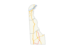
Delaware Route 30
| ||||
|---|---|---|---|---|
 | ||||
| Route information | ||||
| Maintained by DelDOT | ||||
| Length: | 44.94 mi[1] (72.32 km) | |||
| Existed: | 1938[2] – present | |||
| Major junctions | ||||
| West end: | Bi-State Boulevard between Laurel and Delmar | |||
|
| ||||
| North end: |
| |||
| Location | ||||
| Counties: | Sussex | |||
| Highway system | ||||
| ||||

Delaware Route 30 (DE 30) is a state highway in Sussex County, Delaware. The route runs from an intersection with Bi-State Boulevard a short distance west of U.S. Route 13 (US 13) between Laurel and Delmar to DE 1 Business (DE 1 Bus.) southeast of Milford in the area of Lincoln and Cedar Creek. The road runs east to Gumboro, where it turns north on the Millsboro Highway to Millsboro. Along this road, DE 30 shares concurrencies with DE 26, DE 54, and DE 24. From Millsboro, the route passes through Gravel Hill and to the west of Milton before reaching Milford. DE 30 has an alternate route, DE 30 Alternate (DE 30 Alt.), that was created by 1999 to connect the route with DE 1 by way of Johnson Road. DE 30 is signed as an east-west road from the southern terminus to the east end of the DE 24 concurrency in Millsboro and as a north-south road from that point until the northern terminus.
What is now DE 30 south of Gravel Hill was built as a state highway in various stages during the 1920s and 1930s. DE 30 was first designated by 1938 to connect DE 24 in Millsboro to DE 5 in Milton. The route was rerouted to end at DE 14 (now DE 1) south of Milford by 1971. DE 30 was extended southwest to Bi-State Boulevard by 1994 and its northern terminus was moved to DE 1 Business by way of a new road by 2003. An interchange with DE 1 was completed in 2014.
Route description
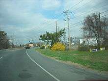
DE 30 begins at an intersection with Bi-State Boulevard in southwestern Sussex County between Laurel and Delmar, heading east on two-lane undivided Whitesville Road. A short distance later, the road crosses US 13, passing through a mix of farmland and woodland with some homes to the south of Trap Pond State Park. The route turns southeast before it curves to the east again. Farther east, DE 30 comes to an intersection with DE 26/DE 54.[3][4]
At this point, DE 30 turns northeast to form a concurrency with DE 26/DE 54 on Millsboro Highway. The road curves north and heads into the residential community Gumboro, where DE 54 splits to the east. DE 26/DE 30 leaves Gumboro and continues back into areas of farms and forests with occasional residences. In Shaft Ox Corner, DE 26 splits to the east and DE 30 heads north to an intersection with DE 24 in Mission.[3][4]
Here, DE 24 turns north to join DE 30, with the road running northeast. Farther along, residential development increases as the road heads into Millsboro. At this point, the road names becomes Laurel Road and it reaches an intersection with US 113/DE 20. Past this intersection, DE 24/DE 30 turns north-northeast on Washington Street. The two routes split into a one-way pair following Main Street northbound and Washington Street southbound, crossing Norfolk Southern's Indian River Secondary railroad line. The one-way pair runs through the downtown area of Millsboro, rejoining along two-way Main Street and crossing Indian River to the east of Millsboro Pond. A short distance later, DE 24 and DE 30 split at an intersection.[3][4]
Upon splitting from DE 24, DE 30 signage changes from east-west to north-south and the route leaves Millsboro. It continues north on Gravel Hill Road, passing to the east of Millsboro Pond. The road heads through a mix of farmland and woodland with some homes. In the community of Zoar, the route intersects DE 24 Alt. Farther north, DE 30 reaches the community of Gravel Hill. In Gravel Hill, the road crosses a Delaware Coast Line Railroad line and comes to an intersection with US 9/DE 404. From this point, the route curves northwest before bending north again. DE 30 intersects DE 5 Alt., which serves as a western bypass of Milton for DE 5. Here, DE 5 Alt. turns north to form a concurrency with DE 30, with the road crossing an abandoned railroad line just east of the terminus of a Delaware Coast Line Railroad branch. At an intersection with DE 16, DE 5 Alt. heads east along with that route and DE 30 continues north on Isaacs Road.[3][4]
The route heads away from Milton and passes to the east of Reynolds Pond. DE 30 intersects Cedar Creek Road and turns northwest onto that road, curving north and back to the northwest. The road runs to the east of Swiggets Pond and intersects DE 30 Alt., which heads northeast to an intersection with DE 1. DE 30 continues north-northwest and comes to ramps providing access to and from the southbound lanes of DE 1. At this point, the route gains a center left-turn lane and reaches an intersection with Wilkins Road, which provides access to and from the northbound lanes of DE 1 at an interchange. Past this intersection, DE 30 turns northwest and passes between residential subdivisions to the southwest and DE 1 to the northeast as a two-lane road, coming to its northern terminus at an intersection with DE 1 Bus. at the point that route merges into DE 1 at an interchange southeast of Milford.[3][4]
DE 30 has an annual average daily traffic count ranging from a high of 20,273 vehicles at the northern edge of Millsboro to a low of 862 vehicles at the intersection with DE 26/DE 54.[1] None of DE 30 is part of the National Highway System.[5]
History

By 1920, what is now DE 30 existed as a state highway between Mission and Phillips Hill and was proposed as one between Phillips Hill and Millsboro, with the remainder of the route existing as a county road.[6] The state highway between Phillips Hill and Millsboro was completed by 1924.[7] The state highway portion of the present-day route was extended from Mission to Gumboro a year later, with a section in the Gumboro area under proposal as a state highway.[8] By 1931, the road was completed as a state highway between US 13 and Jones Branch and from James Branch to Gumboro. In addition, the state highway was completed from Millsboro to north of Gravel Hill as an unpaved road, with a portion north of Gravel Hill becoming a paved county road.[9] The state highway between US 13 and Gumboro was fully complete the following year.[10] By 1936, the road between Millsboro and Gravel Hill was paved.[11]
By 1938, DE 30 was designated to run from DE 24 in Millsboro north to DE 5 in Milton, following its current alignment to north of Gravel Hill and then running along Shingle Point Road north into Milton.[2] A portion of current DE 30 south of the DE 16 intersection was paved a year later.[12] By 1952, the current route of DE 30 north of Gravel Hill was paved.[13] DE 30 was rerouted to follow its present alignment north to DE 14 (now DE 1) south of Milford by 1971.[14] By 1994, DE 30 was extended from Millsboro to its current terminus at Bi-State Boulevard.[15] DE 30s northern terminus was moved to its current location at DE 1 Business by 2003 when a road connecting DE 30 to DE 1 Business was completed.[16] In November 2012, construction began on an interchange at DE 1 southeast of Milford. The interchange between DE 1 and DE 30 was completed in July 2014.[17]
Major intersections
The entire route is in Sussex County.
| Location | mi[1] | km | Destinations | Notes | |
|---|---|---|---|---|---|
| | 0.00 | 0.00 | Bi-State Boulevard | Western terminus | |
| | 0.54 | 0.87 | |||
| Gumboro | 10.73 | 17.27 | West end of DE 26/DE 54 overlap | ||
| 12.27 | 19.75 | East end of DE 54 overlap | |||
| Shaft Ox Corner | 15.58 | 25.07 | East end of DE 26 overlap | ||
| Mission | 16.50 | 26.55 | West end of DE 24 overlap | ||
| Millsboro | 21.52 | 34.63 | |||
| 22.31 | 35.90 | East end of DE 24 overlap | |||
| Zoar | 25.91 | 41.70 | |||
| Gravel Hill | 30.77 | 49.52 | |||
| Milton | 35.11 | 56.50 | South end of DE 5 Alt. overlap | ||
| 36.23 | 58.31 | North end of DE 5 Alt. overlap | |||
| Cedar Creek | 43.45 | 69.93 | |||
| Milford | 44.79 | 72.08 | Interchange, access to and from northbound DE 1 provided by Wilkins Road | ||
| 44.94 | 72.32 | Northern terminus | |||
1.000 mi = 1.609 km; 1.000 km = 0.621 mi
| |||||
Bannered routes
| |
|---|---|
| Location: | Cedar Creek |
| Length: | 0.74 mi[18] (1.19 km) |
| Existed: | 1999[19]–present |
Delaware Route 30 Alternate (DE 30 Alt.) is a 0.74 miles (1.19 km)[18] alternate route of DE 30 south of the city of Milford in the Cedar Creek area. It runs from DE 30 northeast to DE 1 along Johnson Road, passing through a mix of farmland, woodland, and residential development.[20] The route was created by 1999.[19]
See also
 U.S. Roads portal
 Delaware portal
References
- 1 2 3 Staff (2011). "Traffic Count and Mileage Report: Interstate, Delaware, and US Routes" (PDF). Delaware Department of Transportation. Retrieved May 17, 2012.
- 1 2 Delaware State Highway Department; The National Survey Co. (1938). Official Road Map of the State of Delaware (PDF) (Map). Dover: Delaware State Highway Department. Retrieved November 24, 2015.
- 1 2 3 4 5 Delaware Department of Transportation (2008). Delaware Official Transportation Map (PDF) (Map). Dover: Delaware Department of Transportation. Retrieved November 24, 2015.
- 1 2 3 4 5 Google (August 26, 2010). "overview of Delaware Route 30" (Map). Google Maps. Google. Retrieved August 26, 2010.
- ↑ National Highway System: Delaware (PDF) (Map). Federal Highway Administration. 2010. Retrieved February 10, 2012.
- ↑ Delaware State Highway Department (1920). Official Road Map (PDF) (Map). Dover: Delaware State Highway Department. Retrieved November 24, 2015.
- ↑ Delaware State Highway Department (1924). Official Road Map (PDF) (Map). Dover: Delaware State Highway Department. Retrieved November 24, 2015.
- ↑ Delaware State Highway Department (1925). Official Road Map (PDF) (Map). Dover: Delaware State Highway Department. Retrieved November 24, 2015.
- ↑ Delaware State Highway Department (1931). Official Road Map of the State of Delaware (PDF) (Map). Dover: Delaware State Highway Department. Retrieved November 24, 2015.
- ↑ Delaware State Highway Department (1932). Official Road Map (PDF) (Map). Dover: Delaware State Highway Department. Retrieved November 24, 2015.
- ↑ Delaware State Highway Department; The National Survey Co. (1936). Official Road Map of the State of Delaware (PDF) (Map) (1936–37 ed.). Dover: Delaware State Highway Department. Retrieved November 24, 2015.
- ↑ Delaware State Highway Department (1939). Official Road Map of the State of Delaware (PDF) (Map). Dover: Delaware State Highway Department. Retrieved November 24, 2015.
- ↑ Delaware State Highway Department (1952). Official Highway Map of Delaware (PDF) (Map) (1952–53 ed.). Dover: Delaware State Highway Department. Retrieved November 24, 2015.
- ↑ Delaware Department of Highways and Transportation (1971). Delaware Highways Official Map (PDF) (Map). Dover: Delaware Department of Highways and Transportation. Retrieved November 24, 2015.
- ↑ Delaware Department of Transportation; Division of Planning Cartographic Information Section (1994). Delaware Official State Map (PDF) (Map). Dover: Delaware Department of Transportation. Retrieved November 24, 2015.
- ↑ Delaware Department of Transportation (2003). Delaware Official Transportation Map (PDF) (Map). Dover: Delaware Department of Transportation. Retrieved November 24, 2015.
- ↑ "Routes 1 and 30 Grade Separated Intersection Completed". Delaware Department of Transportation. July 25, 2014. Retrieved August 4, 2014.
- 1 2 Staff (2011). "Traffic Count and Mileage Report: Sussex County" (PDF). Delaware Department of Transportation. Retrieved June 26, 2012.
- 1 2 Delaware Department of Transportation (1999). Delaware Official Transportation Map (PDF) (Map). Dover: Delaware Department of Transportation. Retrieved November 24, 2015.
- ↑ Google (August 26, 2010). "overview of Delaware Route 30 Alternate" (Map). Google Maps. Google. Retrieved August 26, 2010.
External links
 Media related to Delaware Route 30 at Wikimedia Commons