Delaware Route 12
| ||||
|---|---|---|---|---|
 | ||||
| Route information | ||||
| Maintained by DelDOT | ||||
| Length: | 16.19 mi[1] (26.06 km) | |||
| Existed: | 1936[2] – present | |||
| Major junctions | ||||
| West end: |
| |||
|
| ||||
| East end: |
| |||
| Location | ||||
| Counties: | Kent | |||
| Highway system | ||||
| ||||

Delaware Route 12 (DE 12) is a state highway in Kent County, Delaware, United States. It runs from Maryland Route 314 (MD 314) at the Maryland border near Whiteleysburg, Maryland east to an interchange with DE 1 near Frederica. The route follows a mostly rural alignment, passing through the towns of Felton and Frederica. DE 12 intersects U.S. Route 13 (US 13) in Felton and DE 15 east of Felton. What would become DE 12 was built as a state highway during the 1920s. DE 12 was designated between Felton and Frederica by 1936 and extended west to Maryland by 1938. The eastern terminus was moved to its current location in 1965 when US 113 (now DE 1) was routed to bypass Frederica. The DE 1 intersection became an interchange in 2011.
Route description
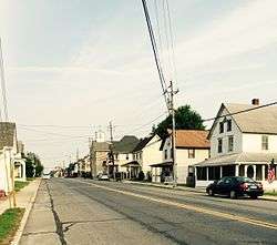
DE 12 begins at the Maryland border, continuing west into that state as MD 314 at the state line. From the state line, the route heads southeast on two-lane undivided Whiteleysburg Road briefly before turning northeast onto Whites Lane. A short distance later, DE 12 intersects Two State Road and becomes Burnite Mill Road. The road runs through farmland with some woods and homes, curving east and entering Felton. At this point, DE 12 becomes Main Street and heads into residential areas, crossing Norfolk Southern's Delmarva Secondary railroad line. The road comes to an intersection with US 13 on the eastern edge of Felton.[3][4]
Upon leaving Felton, the route becomes Midstate Road and continues through agricultural areas with some woods and homes. DE 12 crosses DE 15 and comes to an intersection with Andrews Lake Road, where the name changes to Johnnycake Landing Road. The road passes through more rural areas before entering Frederica, where it becomes Front Street and is lined with homes. In the eastern part of town, the route splits into the one-way pair of David Street eastbound and Front Street westbound. DE 12 turns north onto two-way Frederica Road and leaves Frederica, passing through marshland and crossing Spring Creek, a branch of the Murderkill River. DE 12 continues to its eastern terminus at an interchange with DE 1.[3][4]
DE 12 has an annual average daily traffic count ranging from a high of 5,207 vehicles where it intersects Frederica Road from the west to a low of 2,204 vehicles at the eastern terminus at DE 1.[1] None of DE 12 is part of the National Highway System.[5]
History
What is now DE 12 existed as an unimproved county road by 1920.[6] By 1924, the route was completed as a state highway between Hollandsville and Frederica and was proposed as a state highway between the Maryland border in Whiteleysburg and Hollandsville and within Frederica.[7] The entire road between Whiteleysburg and Frederica was built as a state highway a year later.[8] DE 12 was designated to run from US 13 in Felton to US 113 (Frederica Road) in Frederica by 1936.[2] By 1938, DE 12 was extended west to the Maryland border in Whiteleysburg.[9]
In 1965, US 113 was moved to a bypass to the east of Frederica, and DE 12 was extended north on the former alignment of US 113 to end at that route a short distance north of Frederica.[10] In November 2009, construction began for a grade-separated interchange at DE 1 (which had replaced US 113); the interchange was completed in June 2011.[11][12]
Major intersections
The entire route is in Kent County.
| Location | mi[1] | km | Destinations | Notes | |
|---|---|---|---|---|---|
| | 0.00 | 0.00 | Maryland state line, western terminus | ||
| Felton | 9.84 | 15.84 | |||
| | 12.24 | 19.70 | |||
| Frederica | 16.19 | 26.06 | DE 1 exit 86, eastern terminus | ||
| 1.000 mi = 1.609 km; 1.000 km = 0.621 mi | |||||
See also
 U.S. Roads portal
 Delaware portal
References
- 1 2 3 Staff (2011). "Traffic Count and Mileage Report: Interstate, Delaware, and US Routes" (PDF). Delaware Department of Transportation. Retrieved May 17, 2012.
- 1 2 Delaware State Highway Department; The National Survey Co. (1936). Official Road Map of the State of Delaware (PDF) (Map) (1936–37 ed.). Dover: Delaware State Highway Department. Retrieved November 24, 2015.
- 1 2 Delaware Department of Transportation (2008). Delaware Official Transportation Map (PDF) (Map). Dover: Delaware Department of Transportation. Retrieved November 24, 2015.
- 1 2 Google (August 20, 2010). "overview of Delaware Route 12" (Map). Google Maps. Google. Retrieved August 20, 2010.
- ↑ National Highway System: Delaware (PDF) (Map). Federal Highway Administration. 2010. Retrieved February 10, 2012.
- ↑ Delaware State Highway Department (1920). Official Road Map (PDF) (Map). Dover: Delaware State Highway Department. Retrieved November 24, 2015.
- ↑ Delaware State Highway Department (1924). Official Road Map (PDF) (Map). Dover: Delaware State Highway Department. Retrieved November 24, 2015.
- ↑ Delaware State Highway Department (1925). Official Road Map (PDF) (Map). Dover: Delaware State Highway Department. Retrieved November 24, 2015.
- ↑ Delaware State Highway Department; The National Survey Co. (1938). Official Road Map of the State of Delaware (PDF) (Map). Dover: Delaware State Highway Department. Retrieved November 24, 2015.
- ↑ Delaware State Highway Department (1965). Official Highway Map of Delaware (PDF) (Map). Dover: Delaware State Highway Department. Retrieved November 24, 2015.
- ↑ "Construction to begin for Route 1, North Frederica Grade Separated Intersection". Delaware Department of Transportation. November 23, 2009. Retrieved December 29, 2009.
- ↑ "TRAFFIC ALERT - Opening of Route 1, North Frederica Overpass". Delaware Department of Transportation. June 24, 2011. Retrieved July 8, 2011.