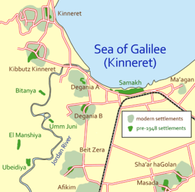
Degania Bet
| Degania Bet דְּגַנְיָה ב' | |
|---|---|
| Hebrew transcription(s) | |
| • standard | Dganya Bet |
 | |
 Degania Bet | |
| Coordinates: 32°42′0″N 35°34′33.6″E / 32.70000°N 35.576000°ECoordinates: 32°42′0″N 35°34′33.6″E / 32.70000°N 35.576000°E | |
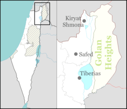
| District | Northern |
| Council | Emek HaYarden |
| Affiliation | Kibbutz Movement |
| Founded | 1920 |
| Founded by | Immigrants from the Second Aliyah |
| Population (2015)[1] | 643 |
| Website | www.degania-b.org.il |
Degania Bet (Hebrew: דְּגַנְיָה ב') is a kvutza or kibbutz in northern Israel. Located to the south of the Sea of Galilee adjacent to Degania Alef, it falls under the jurisdiction of Emek HaYarden Regional Council. Degania Bet was established in 1920. In 2015 it had a population of 643.
History
British Mandate
Degania Bet was founded in 1920 by immigrants from the Second Aliyah,[2] led by Levi Brevda (Levi Ben Amitai).[3] It was the first planned kibbutz and was designed and built by the German Jewish architect Fritz Kornberg.[4][5] One of its founders was Levi Eshkol. During the 1920 Palestine riots it was attacked and abandoned for several months.[2]
During the 1936–39 Arab revolt it served as a base for establishing tower and stockade settlements.
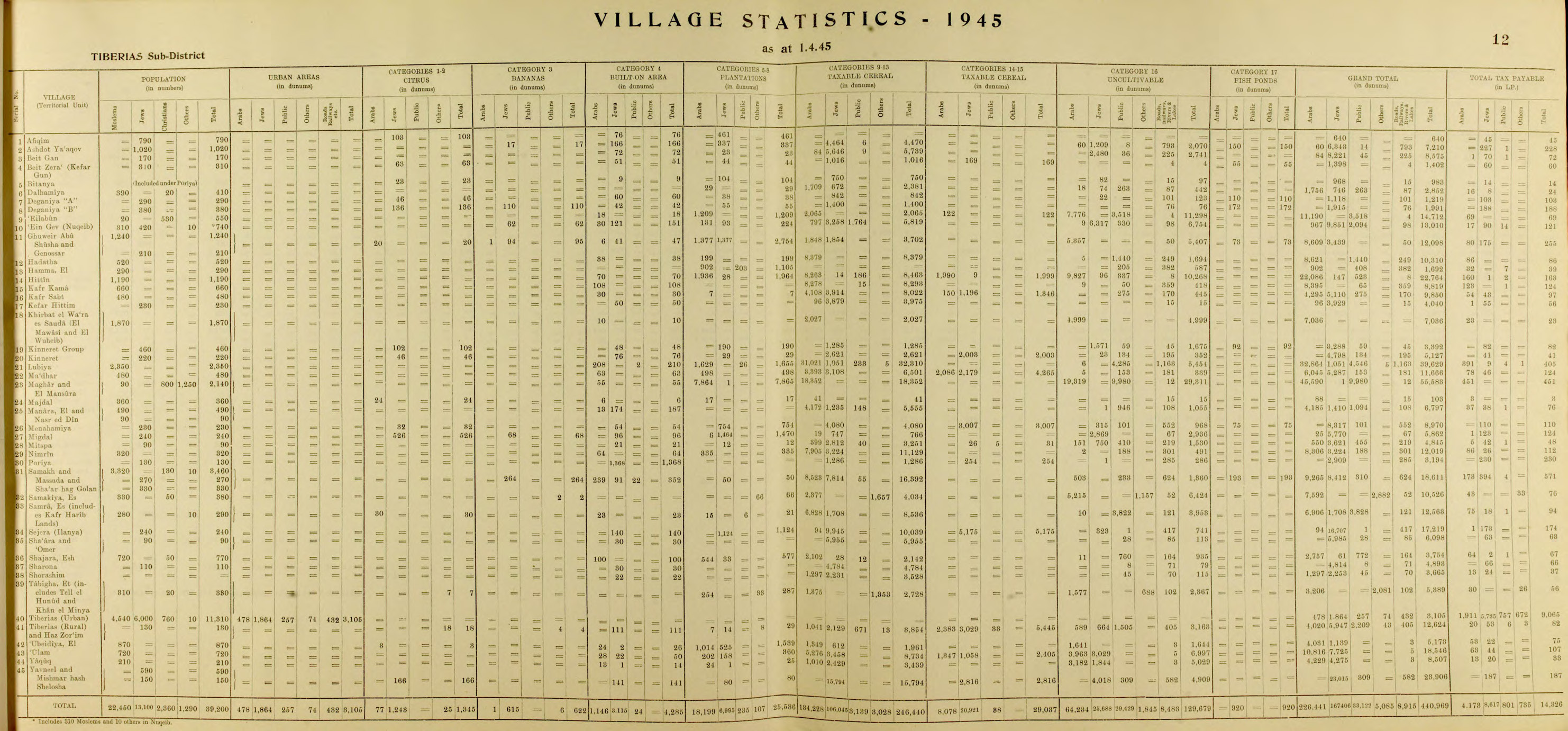
In the 1931 census of Palestine Deganya B had a population of 138, all Jews, in a total of 39 houses.[6] increasing in 1945, to 290, still all Jewish.[7]
War of Independence 1948
On May 20, 1948, during the Battles of the Kinarot Valley, in one of the first battles of the 1948 Arab-Israeli war, the residents of Degania Alef and Bet, assisted by a small number of military personnel, repelled a Syrian attack and succeeded in halting the advance of the Syrian army into the Jordan Valley.[2]
Economy
In addition to its 350 cow dairy herd, crop fields, almond orchards, banana, date and avocado plantations, Degania Bet industrialized in the 1960s with Degania Sprayers, now a green industry; in 1984 it opened the Degania Silicone factory. An additional source of income is its kibbutz cottage tourist accommodation, and it specializes in organized bicycle tours.
Notable residents
- Levi Eshkol (1895–1969), the third Prime Minister of Israel (1963–69); Degania Bet member
- Kadish Luz, Minister of Agriculture (1955–59) and Speaker of the Knesset (1959–69), acting President for one month in 1963; Degania Bet member
- Michael Kolganov, Soviet-born Israeli sprint canoeist, world champion, bronze medalist at 2000 Summer Olympics; Degania Bet non-member resident in the 2000s
References
- ↑ "List of localities, in Alphabetical order" (PDF). Israel Central Bureau of Statistics. Retrieved 16 October 2016.
- 1 2 3 Mapa's concise gazetteer of Israel (in Hebrew). Yuval El'azari (ed.). Tel-Aviv: Mapa Publishing. 2005. p. 125. ISBN 965-7184-34-7.
- ↑ Shtetl Links: Lyakhovichi Kehlia Links
- ↑ Shmuel Burmil, Ruth Enis (2011). The Changing Landscape of a Utopia: The Landscape and Gardens of the Kibbutz. Past and Present. Grüne Reihe - Quellen und Forschungen zur Gartenkunst (Band 29). pp. 154–158. ISBN 978-3-88462-284-1.
- ↑ Chyutin, Michael and Bracha (2007-04-24). Architecture and Utopia. Ashgate Pub Co. p. 90. ISBN 0-7546-4831-1.
- ↑ Mills, 1932, p. 82
- ↑ Department of Statistics, 1945, p. 12
Bibliography
| Wikimedia Commons has media related to Degania Bet. |
- Conder, Claude Reignier; Kitchener, Herbert H. (1882). The Survey of Western Palestine: Memoirs of the Topography, Orography, Hydrography, and Archaeology. 2. London: Committee of the Palestine Exploration Fund.
- Department of Statistics (1945). Village Statistics, April, 1945. Government of Palestine.
- Guérin, Victor (1880). Description Géographique Historique et Archéologique de la Palestine (in French). 3: Galilee, pt. 1. Paris: L'Imprimerie Nationale.
- Karmon, Y. (1960). "An Analysis of Jacotin's Map of Palestine" (PDF). Israel Exploration Journal. 10 (3,4): 155–173; 244–253.
- Mills, E., ed. (1932). Census of Palestine 1931. Population of Villages, Towns and Administrative Areas. Jerusalem: Government of Palestine.
- Palmer, E. H. (1881). The Survey of Western Palestine: Arabic and English Name Lists Collected During the Survey by Lieutenants Conder and Kitchener, R. E. Transliterated and Explained by E.H. Palmer. Committee of the Palestine Exploration Fund.
External links
- Kvutza website (Hebrew)
- Survey of Western Palestine, Map 6: IAA, Wikimedia commons