Almagor
This article is about the Israeli moshav. For people named Almagor, see Almagor (disambiguation).
| Almagor | |
|---|---|
 | |
 Almagor | |
| Coordinates: 32°54′45″N 35°36′7.56″E / 32.91250°N 35.6021000°ECoordinates: 32°54′45″N 35°36′7.56″E / 32.91250°N 35.6021000°E | |
| Council | Emek HaYarden |
| Region | Sea of Galilee |
| Affiliation | Moshavim Movement |
| Founded | 1961 |
| Founded by | Nahal |
| Population (2015)[1] | 349 |
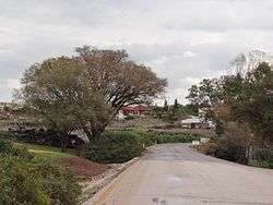
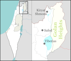
Almagor (Hebrew: אַלְמָגוֹר) is a moshav in northern Israel.[2][3] Located to the north of the Sea of Galilee, it falls under the jurisdiction of Emek HaYarden Regional Council. In 2015 it had a population of 349.
The village was established in 1961 as a Nahal settlement, before being turned into a civilian area in 1965. Its name is derived from a word combination meaning "lack of fear" (al meaning "without"; magor meaning "fear"). Prior to the foundation of the moshav, the area had been the site for the Battle of Tel Motila, a clash between Israel and Syria on 2 May 1951. Today a large memorial stands at the site.[4]
References
- ↑ "List of localities, in Alphabetical order" (PDF). Israel Central Bureau of Statistics. Retrieved 16 October 2016.
- ↑ Oren, Michael. Six Days of War: June 1967 and the making of the modern Middle East. RosettaBooks. Retrieved September 5, 2011.
- ↑ Samantha Wilson. Israel, 2nd. Retrieved September 5, 2011.
- ↑ Tel Motila (Kela Hill) eKinneret
This article is issued from Wikipedia - version of the 10/29/2016. The text is available under the Creative Commons Attribution/Share Alike but additional terms may apply for the media files.