Dawson City Airport
| Dawson City Airport | |||||||||||
|---|---|---|---|---|---|---|---|---|---|---|---|
 | |||||||||||
|
IATA: YDA – ICAO: CYDA – WMO: 71966 | |||||||||||
| Summary | |||||||||||
| Airport type | Public | ||||||||||
| Operator | Government of Yukon | ||||||||||
| Location | Dawson City, Yukon | ||||||||||
| Time zone | PST (UTC−08:00) | ||||||||||
| • Summer (DST) | PDT (UTC−07:00) | ||||||||||
| Elevation AMSL | 1,215 ft / 370 m | ||||||||||
| Coordinates | 64°02′32″N 139°07′49″W / 64.04222°N 139.13028°WCoordinates: 64°02′32″N 139°07′49″W / 64.04222°N 139.13028°W | ||||||||||
| Map | |||||||||||
 CYDA Location in Yukon | |||||||||||
| Runways | |||||||||||
| |||||||||||
| Statistics (2010) | |||||||||||
| |||||||||||
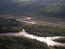
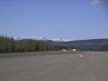
Dawson City Airport (IATA: YDA, ICAO: CYDA) is located 8 nautical miles (15 km; 9.2 mi) east of Dawson City, Yukon, Canada, in the Klondike River valley, and is operated by the Yukon government. It has a terminal building and like most airports in its class, the runway is not paved. The gravel runway is 5,006 ft (1,526 m) long and at an elevation of 1,215 ft (370 m). A number of studies have recommended moving the airport or realigning the runway as it is in a narrow mountain valley.
The airport is classified as an airport of entry by Nav Canada and is staffed by the Canada Border Services Agency (CBSA). CBSA officers at this airport can normally handle aircraft with up to 15 passengers, but are equipped to handle daily Boeing 737 charters between Dawson City and Fairbanks (Fairbanks International Airport) during the peak summer tourism season.[1]
Airlines and destinations
| Airlines | Destinations |
|---|---|
| Air North | Inuvik, Old Crow, Whitehorse Seasonal: Fairbanks |
| Great River Air | On Demand Charter |


See also
References
- 1 2 Canada Flight Supplement. Effective 0901Z 15 September 2016 to 0901Z 10 November 2016
- ↑ Synoptic/Metstat Station Information
- ↑ Total aircraft movements by class of operation
External links
- Page about this airport on COPA's Places to Fly airport directory
- Past three hours METARs, SPECI and current TAFs for Dawson City Airport from Nav Canada as available.
| By name | |
|---|---|
| By location indicator | |
| By province/territory | |
| By region | |
| National Airports System | |
| Related | |
| |