Dawlish Water
| Dawlish Water | |
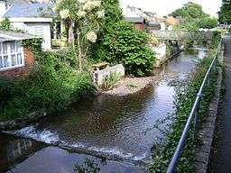 Dawlish Water in Dawlish | |
| Country | England |
|---|---|
| Counties | Devon |
| Mouth | |
| - location | Dawlish |
| - coordinates | 50°34′48″N 3°27′54″W / 50.5801°N 3.465°WCoordinates: 50°34′48″N 3°27′54″W / 50.5801°N 3.465°W |
Dawlish Water is a minor coastal stream which flows through Devon, England.[1]
It rises in Haldon Forest by the A380 road and flows southeast through Ashcombe to Dawlish flowing over a series of weirs, (this part of Dawlish is prone to flooding) through the centre of the town under the A379 road and the London to Penzance railway line before terminating in the English Channel.[2]
The water level of the stream has been measured in Dawlish since 2012, normal levels are between 0.12 metres (4.7 in) and 0.33 metres (1 ft 1 in). The maximum recorded level was 1.32 metres (4 ft 4 in) in November 2012.[3]
References
- ↑ "Dawlish Water". teignbridge.gov.uk. Retrieved 31 December 2015.
- ↑ "Dawlish Water". Catchment Data Explorer. Environment Agency. Retrieved 30 December 2015.
- ↑ "Dawlish Water at Dawlish". Environment Agency. Retrieved 31 December 2015.
External links
![]() Media related to Dawlish Water at Wikimedia Commons
Media related to Dawlish Water at Wikimedia Commons
This article is issued from Wikipedia - version of the 3/20/2016. The text is available under the Creative Commons Attribution/Share Alike but additional terms may apply for the media files.