Dartmoor, Victoria
| Dartmoor Victoria | |
|---|---|
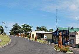 War memorial sculptures | |
 Dartmoor | |
| Coordinates | 37°56′0″S 141°17′0″E / 37.93333°S 141.28333°ECoordinates: 37°56′0″S 141°17′0″E / 37.93333°S 141.28333°E |
| Population | 263 (2011 census)[1] |
| Postcode(s) | 3304 |
| Location |
|
| LGA(s) | Shire of Glenelg |
| County | Follett |
| State electorate(s) | Lowan |
| Federal Division(s) | Wannon |
Dartmoor /ˈdɑːtmɔː/[2] is a rural township on the Princes Highway and the Glenelg River between Heywood and the South Australian border, in southwestern Victoria. At the 2011 census, Dartmoor had a population of 263.[3]
History
Before the township was established the location was known as Woodford Inn. The township was settled in the late 1850s, a Post Office opening on 1 April 1860.[4]
Today
The main industry in the area is the processing of timber from the extensive pine plantations.
Dartmoor has a football team playing in the South West District Football League.[5]
Golfers play at the Dartmoor Golf Club on Wapling Avenue.[6]
Notable residents
- Jeremy Cameron, Australian rules footballer[7]
References
- ↑ "2011 Census QuickStats: Dartmoor (Vic.)". Australia Bureau of Statistics. Retrieved 11 May 2013.
- ↑ Butler, S., ed. (2009). "Dartmoor". Macquarie Dictionary (5th ed.). Sydney: Macquarie Dictionary Publishers Pty Ltd. 1952 pages. ISBN 978-1-876429-66-9.
- ↑ "2011 Census QuickStats: Dartmoor (Vic.)". Australia Bureau of Statistics. Retrieved 11 May 2013.
- ↑ Premier Postal History, Post Office List, retrieved 2008-04-11
- ↑ Full Points Footy, Dartmoor, retrieved 2009-04-15
- ↑ Golf Select, Dartmoor, retrieved 2009-05-11
- ↑ Sydney Is Home Says Cameron, GWS Giants official website, 27 May 2014
External links
![]() Media related to Dartmoor, Victoria at Wikimedia Commons
Media related to Dartmoor, Victoria at Wikimedia Commons
This article is issued from Wikipedia - version of the 11/3/2016. The text is available under the Creative Commons Attribution/Share Alike but additional terms may apply for the media files.