Dachau (district)
| Dachau | |
|---|---|
| District | |
 | |
| Country |
|
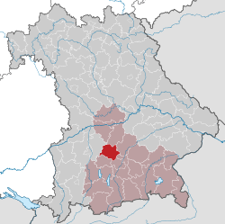
| State | Bavaria |
| Adm. region | Oberbayern |
| Capital | Dachau |
| Area | |
| • Total | 579 km2 (224 sq mi) |
| Population (31 December 2015)[1] | |
| • Total | 149,370 |
| • Density | 260/km2 (670/sq mi) |
| Time zone | CET (UTC+1) |
| • Summer (DST) | CEST (UTC+2) |
| Vehicle registration | DAH |
| Website | landratsamt-dachau.de |
Dachau is a district in Bavaria, Germany. It is bounded by (from the south and clockwise) the districts of Fürstenfeldbruck, Aichach-Friedberg, Pfaffenhofen, Freising and Munich, and by the city of Munich.
History
The district was established in 1952. There were slight changes to the territory in the administrative reform of 1972.
Geography
The district extends from the northwestern suburbs of Munich to the so-called Dachauer Land. It is a hilly countryside, which is now densely populated. The growing Munich metropolitan area is advancing more and more into the district's territory.
Coat of arms
 |
The arms include a red zigzag line on white background, which was the heraldic figure of the Wittelsbach family during the 12th and 13th century. Although it was not used anymore from the 14th century on, it is now part of the arms of Dachau in order to symbolise, that Dachau is an old part of the Bavarian state. In the upper part of the arms the blue and white checkered pattern of Bavaria is displayed. |
Towns and municipalities
| Towns | Municipalities | |
|---|---|---|
References
- ↑ "Fortschreibung des Bevölkerungsstandes". Bayerisches Landesamt für Statistik und Datenverarbeitung (in German). June 2016.
External links
| Wikimedia Commons has media related to Landkreis Dachau. |
- Official website (German)
Coordinates: 48°15′N 11°25′E / 48.25°N 11.42°E
This article is issued from Wikipedia - version of the 11/10/2016. The text is available under the Creative Commons Attribution/Share Alike but additional terms may apply for the media files.