Aschaffenburg
| Aschaffenburg | ||
|---|---|---|
|
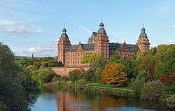
Schloss Johannisburg on the river Main | ||
| ||
 Aschaffenburg | ||
| Coordinates: 49°58′0″N 9°09′0″E / 49.96667°N 9.15000°ECoordinates: 49°58′0″N 9°09′0″E / 49.96667°N 9.15000°E | ||
| Country | Germany | |
| State | Bavaria | |
| Admin. region | Lower Franconia | |
| District | Urban district | |
| Government | ||
| • Lord Mayor | Klaus Herzog (SPD) | |
| Area | ||
| • Total | 62.45 km2 (24.11 sq mi) | |
| Population (2015-12-31)[1] | ||
| • Total | 68,986 | |
| • Density | 1,100/km2 (2,900/sq mi) | |
| Time zone | CET/CEST (UTC+1/+2) | |
| Postal codes | 63739–63743 (old: 8750) | |
| Dialling codes | 06021, 06028 (Obernau) | |
| Vehicle registration | AB | |
| Website | www.aschaffenburg.de | |

Aschaffenburg (German pronunciation: [aˈʃafənbʊɐ̯k]) is a city in northwest Bavaria, Germany. The town of Aschaffenburg is not considered part of the district of Aschaffenburg, but is the administrative seat.
Aschaffenburg belonged to the Archbishopric of Mainz for more than 800 years. The city is located at the westernmost border of Lower Franconia and separated from the central and eastern part of the administrative district by the Spessart hills, whereas it opens towards the Rhine-Main plain in the west and north-west. Therefore, the inhabitants speak neither Bavarian nor East Franconian but rather a local version of Rhine Franconian.
Geography
Location
The town is located on both sides of the Main in the southwest part of Germany, 41 kilometers (25 mi) southeast of Frankfurt am Main. In the western part of Aschaffenburg, the smaller Aschaff flows into the Main. The region is also known as Bayerischer Untermain or "Bavarian Lower Main". Aschaffenburg lies in the far northwest of the state of Bavaria, close to the border to Hesse.
Climate
The climate is continental, typically with warm, dry summers and cold, damp winters. Aschaffenburg usually receives less snowfall during the winter than the nearby Spessart.
Subdivision
Aschaffenburg comprises 10 districts:
- Damm
- Gailbach
- Leider
- Nilkheim
- Obernau
- Obernauer Kolonie
- Österreicher Kolonie (Austrian Colony)
- Schweinheim
- Stadtmitte (town center)
- Strietwald
Nilkheim and Leider are the only districts which are located on the left bank of the river Main.
Neighbouring communities
The following municipalities border Aschaffenburg:
Johannesberg, Glattbach, Goldbach, Haibach, Bessenbach, Sulzbach am Main, Niedernberg, Großostheim, Stockstadt am Main and Mainaschaff.
History
Etymology
The name Aschaffenburg (Ascaffaburc, Ascapha or Ascaphaburg in the Middle Ages) originally meant "castle at the ash tree river" deriving from the river Aschaff that runs through parts of the town.
Pre-history to Middle Ages
The earliest remains of settlements in the area of Aschaffenburg date from the Stone Age.
Aschaffenburg was originally a settlement of the Alamanni. Roman legions were stationed here. In c. 700 AD, the Ravenna Cosmography names two settlements in region: Uburzis (Würzburg) and Ascapha (Aschaffenburg).[2]:69
Around 550, the area had been conquered by the Franks, and their Hausmeier built a castle here. In the 8th century, a Benedictine monastery was founded, dedicated to St. Michael, reportedly by Saint Boniface. This became the Kollegiatstift St. Peter und Alexander in the second half of the 10th century. It is mentioned first in 974 in a gift document by Otto II.[2]:69
In the Middle Ages the town was known as Ascaffaburc, Ascapha or Ascaphaburg. A stone bridge over the Main was built by Archbishop Willigis in 989. In 1292 a synod was held here, and in 1474 an imperial diet, preliminary to that of Vienna, approved a concordat (sometimes called the Aschaffenburg Concordat).[3]
Modern times through 19th century
The town suffered greatly during the Thirty Years' War, being held in turn by the various belligerents. And then again during the Battle of Dettingen (1743), which took place to the north, the town was occupied by French troops. It formed part of the electorate of the Archbishop of Mainz, and in 1803 was made over to Archbishop Karl Theodor von Dalberg as the Principality of Aschaffenburg.
Site of the "Forstliche Hochschule Aschaffenburg" ( Königlich Bayerische Centralforstlehranstalt ), established in 1807, "made famous by the researches of Professor Dr Ernst Ebermayer." The Academy was "dissolved in 1832, but re-organized under the Ministry of Finance in 1874"; and, as "of 30th March, 1874, united to the University of Munich."[4]
In 1810, the Principality of Aschaffenburg was merged into the new Grand Duchy of Frankfurt, although Dalberg retained Aschaffenburg as his residence. In 1814 the city was transferred to the Kingdom of Bavaria by an Austrian-Bavarian treaty. In 1817 it was included within Bavarian Lower Franconia. From 1840–1848, King Ludwig I of Bavaria had a Roman villa built to the west of town. It was named Pompejanum after its model, the house of Castor and Pollux at Pompeii.[5][6]
In 1866, the Prussian Army inflicted a severe defeat on the Austrians in the vicinity during the Austro-Prussian War.
World War II
In World War II, Aschaffenburg was heavily damaged by Allied area bombing, including Schloss Johannisburg which was completely restored several years later. The Germans chose to defend Aschaffenburg with particular steadfastness, which resulted in the "Battle of Aschaffenburg" fought 28 March - 3 April 1945. The US 45th Infantry Division was forced to take the fortified city against stiff German resistance in a series of frontal assaults that involved house-to-house fighting and vicious close combat. The resulting widespread urban destruction was quite severe, as cannon fire was used point-blank to blast through structures.[7]
Aschaffenburg displaced persons camps
At the end of World War II the US Army occupied military facilities formerly used and controlled by the Wehrmacht. These were converted for use by US military personnel as processing centres for displaced persons at the end of the war.[8] From 1945 7,000 Ukrainians were accommodated in four displaced persons camps:[9]
- Artillerie Kaserne — approx. 2,000 people (1945–1949)[10]
- Bois Brulé Kaserne — 1,500 people (1946–1949)[11]
- LaGarde Kaserne — 1,700 people (1945–1949)[12]
- Pionier Kaserne — 2,000 people (1946–1949)[13]
Two other camps, Alte (old) Kaserne and Jäger Kaserne housed mainly Poles and Lithuanians.[14]
Post-war development
In the decades following the war, Aschaffenburg and the surrounding region experienced robust economic prosperity, partially due to its close proximity to Frankfurt am Main.
According to an online 2002 survey in Stern magazine, [Stern 14/2002], 82 percent of residents living in the Bayerischer Untermain region where Aschaffenburg is located were satisfied with the place where they lived. This was the highest level recorded in the survey, making the region the #1 place to live in Germany, based on several factors including employment opportunities in the region, educational facilities, public services, transportation, recreational options, shopping, cultural facilities/events, climate, etc.
Another survey taken in 2006 by McKinsey, Stern magazine, ZDF, and web.de again showed that Aschaffenburg has one of the highest ratings for quality of life in Germany.
US military presence (1945–2007)
Aschaffenburg was the location of several United States Army installations throughout the Cold War. After initially taking over the administration of the ex-Wehrmacht installations, which were then used as displaced persons camps, the American presence in the Aschaffenburg military community began after general renovations in 1948.[8] The installation sites were known as Ready Kaserne (previously Artillerie Kaserne), Smith Kaserne (previously LaGarde Kaserne), Graves Kaserne (previously Bois Brulé Kaserne), Fiori Kaserne (previously Pionier Kaserne), and Jaeger Kaserne (previously Jäger Kaserne). These housed armour, infantry, engineer, maintenance and artillery elements of the US Army 3rd Brigade, 3rd Infantry Division and various VII Corps elements including the 9th Engineer Battalion, the 3rd Bn 21st Field Artillery (Honest John), and the 1st Bn 80th Field Artillery (LANCE). Much of the US Army presence in Aschaffenburg ended in 1992 with the ending of the Cold War. The last buildings, which were primarily used for housing, were handed back to the local government in 2007.
Demographics

Population
|
|
|
Age distribution of current population
| Age | Population |
|---|---|
| 0-19 | 13,888[15] |
| 20-39 | 19,505[15] |
| 40-59 | 18,951[15] |
| 60+ | 16,556[15] |
Economy
In 2013 (latest data available) the GDP per inhabitant was €68,460. This places the kreisfreie Stadt 7th out of 96 districts (rural and urban) in Bavaria (overall average: €36,691).[17]
Well-known companies in Aschaffenburg are (e.g.): Linde Material Handling, Linde Hydraulics, Takata, DPD and redcoon.[18]
Shopping
The City Galerie, opened in 1974 and located in the town center (Stadtmitte), is the largest shopping mall in Northern Bavaria. It was one of the first indoor shopping malls to open in Germany. Aschaffenburg also has a pedestrian shopping zone (Fußgängerzone in German) closed to motor vehicles, except for deliveries. It is located in the town center.
Arts and culture
Cultural events
Aschaffenburg hosts numerous festivals, fairs, exhibitions, markets and concerts throughout the year including the annual Stadtfest, held on the last weekend in August.
Theaters and entertainment venues
- Colos-Saal, a live-music club
- Erthaltheater
- f.a.n. Frankenstolz Arena (formerly Unterfrankenhalle)
- Kabarett im Hofgarten
- Ludwigstheater
- Stadthalle am Schloss
- Stadttheater (City Theater)
- Zimmertheater.
Museums and galleries
- Stiftsmuseum
- Naturwissenschaftlichen Museum Aschaffenburg
- Gentilhaus
- Städtische Galerie "Kunsthalle Jesuitenkirche"
- Neuer Kunstverein Aschaffenburg
- Künstlerhaus Walter Helm
Library
- Stadtbibliothek Aschaffenburg (Aschaffenburg City Library)
Cinemas
- Kinopolis, a modern multiplex cinema
- Casino
Recreation
A large recreational complex is located in the district of Leider. It includes an indoor and outdoor swimming pool complex as well as an indoor ice rink and tennis courts, which are open to the general public. There's also a marina on the Main between the Willigis and Adenauer bridges.
Attractions
Sights
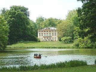
The main sights of Aschaffenburg are the Schloss Johannisburg, built 1605–1614 by Archbishop Johann Schweikhard von Kronberg, which contains a library with a number of incunabula, a collection of engravings and paintings; the Pompejanum, a replica of a Roman town house discovered in Pompeii commissioned by King Ludwig I. and opened in 1850; the Stiftskirche Aschaffenburg collegiate church, founded in 974 by Duke Otto I of Swabia and Bavaria, but dating in the main from the early 12th century on, in which are preserved various monuments by the Vischers, a sarcophagus with the relics of Saint Margaret, and a famous painting by Matthias Grünewald; the Capuchin hospital; a theatre, which was formerly a house of the Teutonic Order; several mansions of the nobility; and the historical Old Town, called "Altstadt" in German. Across the river are the Park and Schloss Schönbusch.
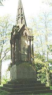
The graves of Clemens Brentano and his brother Christian Brentano (died 1851) and that of Wilhelm Heinse can be found in the Altstadtfriedhof (Old Town Cemetery).[19]
Parks
Aschaffenburg has numerous parks including the following:
- Schönbusch Park, located in Nilkheim
- Schöntal Park, located in the town center
- Aschaffenburger Schlossgarten, around Schloss Johannisburg
- Kleine Schönbuschallee
Sports
Football
Viktoria Aschaffenburg is the primary football club. The club was formed on 24 June 1904 out of the merger of FC Aschaffenburg (6 August 1901) and FC Viktoria Aschaffenburg (12 April 1902). It was renamed Sportverein Viktoria 01 Aschaffenburg on 3 June 1906. Their homefield is Stadion am Schönbusch (Schönbusch stadium), a modern stadium located in the Nilkheim district.
American football
In 1991, the Aschaffenburg Stallions began playing American football at Schönbusch stadium. A cheerleader squad also exists.
Baseball and softball
Aschaffenburg is also home to the Aschaffenburg Mohawks Baseball and Softball team. The softball team won the 2010 German Championship. The adult baseball team won the 2011 Landesliga South Championship and will play in the highest league of the state Hessen in 2012.
Infrastructure
Transportation
Roads
Aschaffenburg is located on Bundesautobahn 3 between Frankfurt am Main and Würzburg. The southern terminus of Bundesautobahn 45 is located just west of the city. Bundesstrasse B 26 passes through the city. Bundestrasse B 8 used to pass through the city, but has now been rerouted along the Bundesautobahn 3. Three road bridges cross the river Main at Aschaffenburg: Ebert Bridge (a new span opened in 2008), Willigis Bridge and Adenauer Bridge. In the 1980s, a road tunnel was constructed under the Schlossplatz to improve traffic flow through the Stadtmitte (town center).
After 43 years of planning and construction, the limited-access Innenstadtring or "inner-city-ring" road was completed in July 2013. It allows motorists to bypass the Stadtmitte (city center) and reduces traffic congestion in Aschaffenburg, which has been a problem in recent years. Another road project called Bahnparallele is currently under construction, with a small section already opened. It is located in the district of Damm and runs parallel to the railway tracks.
Parking
There are approximately 7,500 parking spaces in the ten districts of Aschaffenburg and 8 parking garages open to the public.
Public transport
Aschaffenburg has a comprehensive bus network serving the town and surrounding region. The 15 main bus lines which serve the Stadtteile of Aschaffenburg are run by Stadtwerke Aschaffenburg. There are several other bus lines which link Aschaffenburg with the surrounding region. Those lines are run by other companies, including the Deutsche Bahn. A new regional bus terminal opened in 2008, adjacent to the Aschaffenburg Hauptbahnhof (main railway station). The Regionale Omnibusbahnhof Aschaffenburg (ROB) was built to consolidate all of the scattered bus stops in the area around the main railway station into one central location and reduce traffic congestion in the area.
Railway stations and stops
- Aschaffenburg Hauptbahnhof/Aschaffenburg Central Station - The station has long-distance InterCityExpress and InterCity services as well as regional connections to neighboring towns and cities. A new, larger station building opened in 2011, replacing a smaller structure built in the 1950s.
- Aschaffenburg-Hochschule/University of Applied Sciences - The stop, located near Würzburger Straße, opened in 2007 to accommodate students attending nearby schools. It is positioned between Aschaffenburg Hauptbahnhof and Aschaffenburg-Süd/South. There is only a single track platform.
- Aschaffenburg-Süd/South
- Obernau
- Schönbusch-Nilkheim - The station closed when passenger service on the "Bachgaubahn" railway line ended in 1974.
- Leider - Freight railway terminal close to Aschaffenburg's port on the Main. There is no passenger service.
All passenger train service is provided by the Deutsche Bahn.
Harbor
Aschaffenburg has an active port along the Main in the Stadtteil of Leider. There is railway access to the port. In 2005, 2.8 million tons of cargo passed through the port.
Airports
A small general aviation airport (Flugplatz Aschaffenburg, ICAO-Code: EDFC) is located in nearby Großostheim. Frankfurt Airport is located 46 kilometers (29 mi) from Aschaffenburg and offers flights to destinations all over the world. The trip to and from the airport takes about 30 minutes by car or approximately 45 minutes by InterCityExpress train.
Medical
The three primary medical centers in Aschaffenburg are:
- Klinikum Aschaffenburg, the main hospital
- Hofgartenklinik
- Frauenklinik am Ziegelberg
There are approximately 789 hospital beds, 159 doctors, 68 dentists and 38 pharmacies in the districts of Aschaffenburg.
Education
There are various types of schools in Aschaffenburg serving approximately 18,000 students from the city and surrounding region.
University
Hochschule Aschaffenburg is a university of applied sciences (or Fachhochschule ).
Media
Printed media
- Main-Echo, Aschaffenburg-based newspaper published daily except Sunday. This is the main newspaper for Aschaffenburg and the surrounding region. It was first published on 24 November 1945 replacing "Aschaffenburger Zeitung". It has a daily circulation of approximately 200,000 readers. Main-netz.de is the online distribution site for the newspaper.
- Prima Sonntag, newspaper published only on Sunday
- FRIZZ Das Magazin, culture/scene magazine
- Brot & Spiele, culture magazine
- Szene Magazin
Radio and television
- Radio Primavera
- Radio Galaxy
- Main.tv - Das Primavera Fernsehen, Aschaffenburg programming
Internet
- www.main.tv - video-Website for Aschaffenburg (city and regional)
- Kommweichei.com e.V., the community and party scene in Aschaffenburg
- MainReporter.de - portal for Aschaffenburg (city and regional)
- abscene.de | Newgae magazine
- ABhörn, online Magazine
- Main-netz.de, news and community information for the region
Notable people
Born in Aschaffenburg
Before 1900

- Daniel Brendel von Homburg, 1523–1582, Archbishop of Mainz from 1555 to 1582
- Johann Joseph Scherer, 1814-1869, German chemist
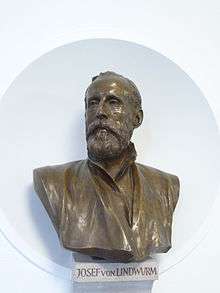
- Joseph von Lindwurm, 1824–1874, German physician and dermatologist
- Lujo Brentano, 1844–1931, German economist and social reformer
- Friedrich von Hefner-Alteneck, 1845–1904, German electrical engineer and one of the closest aides of Werner von Siemens
- Joseph Anton Schneiderfranken, 1876–1943, German painter and author
- Ernst Ludwig Kirchner, 1880–1938, German expressionist painter and printmaker
- Friedrich Dessauer, 1881–1963, German physicist, philosopher, socially engaged entrepreneur and journalist
- Hans Schmidt, 1881–1916, German priest executed for murder in the United States
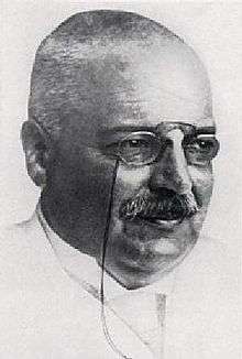
- Alfons Maria Jakob, 1884–1931, German neurologist with important contributions on neuropathology
1900 to 1959

- Hanns Seidel, 1901–1961, German politician and Bavarian prime minister from 1957 to 1960
- Inge Viermetz, 1908–??, German official and defendant at the Nuremberg Trials
- Guido Dessauer, 1915–2012, German physicist, business executive of the Aschaffenburger Buntpapierfabrik, art collector, patron of arts, and academic
- Peter Gingold, 1916–2006, figure in the German Resistance and the National Committee for a Free Germany
- Wilfried Hofmann, born in 1931, German diplomat and author
- Adalbert Kraus, born in 1937, German tenor
- Felix Magath, born in 1953, German footballer and football manager
- Rudi Bommer, born 1957, German footballer and football manager
from 1960
- Urban Priol, born in 1961, German cabaret artist and comedian
- Winfried Bausback, born in 1965, German politician
- Burkard Schliessmann, international classical pianist and concert artist
- Christian Hock, born in 1970, German football player and a football manager
- Carlos Boozer, born in 1981, American basketball player
- Sabine Englert, born in 1981, German team handball goalkeeper
- Marcel Schäfer, born in 1984, German footballer
- José Holebas, born in 1984, German-born Greek footballer
- Markus Neumayr, born in 1986,German footballer
- Ivo Iličević, born in 1986, German-born Croatian football player
- Daria Kinzer, born in 1988, Croatian singer
- Patrick Amrhein, born in 1989, German footballer
- Paul Hill (rugby union), born in 1995, English Rugby union player
Famous residents

- Willigis, 940-1011, Archbishop of Mainz
- Diether von Isenburg, 1412–1482, Elector and Archbishop of Mainz
- Dietrich Schenk von Erbach, ????-1459, Archbishop of Mainz
- Mathis Gothart-Nithart, c. 1475-1528, German Renaissance painter of religious works
- Wolfgang von Dalberg, 1538–1601, Archbishop of Mainz
- Johann Adam von Bicken, 1564–1604, Archbishop of Mainz
- Johann Schweikard von Kronberg (1553-1626), Archbishop of Mainz, commissioned the Schloss Johannisburg
- Friedrich Karl Joseph von Erthal, 1719–1802, prince-elector and archbishop of Mainz
- Carl Theodor Anton Maria Reichsfreiherr von Dalberg, 1744–1817, Archbishop-Elector of Mainz, Arch-Chancellor of the Holy Roman Empire, Prince of Regensburg
- Johann Jakob Wilhelm Heinse, 1746–1803, German author
- Clemens Brentano, 1778–1842, German poet and novelist
- Franz Bopp, 1791–1867, German linguist
- Emil Erlenmeyer, 1825-1909, German chemist
- Alois Alzheimer, 1864–1915, German psychiatrist and neuropathologist
- Ludwig Thoma, 1867–1921, German author, publisher and editor, studied forestry in Aschaffenburg
- Christian Schad, 1894–1982, German painter
- Alfons Goppel, 1905–1991,German politician of the CSU party and Prime Minister of Bavaria
- Ernst Lehner, 1912–1986, German footballer
- Guido Knopp, born in 1948, German journalist and author
- Otto Becker, born in 1958, German show jumping champion
Town twinning
Aschaffenburg is twinned with:
-
 Perth, Scotland, United Kingdom (1956)
 -
 St. Germain-en-Laye, France (1975)
 -
 Miskolc, Hungary (1996)
In 2006, Aschaffenburg and Perth celebrated the 50th anniversary of their partnership.
References
- ↑ "Fortschreibung des Bevölkerungsstandes". Bayerisches Landesamt für Statistik und Datenverarbeitung (in German). June 2016.
- 1 2 Dettelbacher, Werner (1974). Franken - Kunst, Geschichte und Landschaft (German). Dumont Verlag. ISBN 3-7701-0746-2.
- ↑ "Aschaffenburg" in The New Encyclopaedia Britannica. Chicago: Encyclopaedia Britannica Inc., 15th edn., 1992, Vol. 1, p. 617.
- ↑ Barnard, Henry. 1870. "Technical instruction. Special report of the Commissioner of Education." United States House of Representatives, January 19. Accessed: May 7, 2012.
- ↑ "Aschaffenburg - Johannisburg Palace" (PDF). Bayerische Verwaltung der staatlichen Schlösser, Gärten und Seen. Retrieved 13 August 2014.
- ↑ "Pompeiianum". Bayerische Verwaltung der staatlichen Schlösser, Gärten und Seen. Retrieved 12 August 2014.
- ↑ Stanton, Shelby, World War II Order of Battle: An Encyclopedic Reference to U.S. Army Ground Forces from Battalion through Division, 1939-1946 (Revised Edition, 2006), Stackpole Books, p. 134-135
- 1 2 U.S. ARMY INSTALLATIONS - ASCHAFFENBURG
- ↑ 'Ашаффенбурґ', Енциклопедія українознавства ("Encyclopedia of Ukraine") Vol. І, p. 77
- ↑ Artillerie Kaserne, Sälzerweg, Aschaffenburg 49°57′48.18″N 9°10′22.89″E / 49.9633833°N 9.1730250°E
- ↑ Bois Brulé Kaserne, Würzburger Strasse, Aschaffenburg 49°57′48.32″N 9°10′38″E / 49.9634222°N 9.17722°E
- ↑ LaGarde Kaserne, Würzburger Strasse, Aschaffenburg 49°58′1.02″N 9°9′57.75″E / 49.9669500°N 9.1660417°E
- ↑ Pionier Kaserne, Schweinheimer Strasse, Aschaffenburg 49°57′59.06″N 9°9′33.61″E / 49.9664056°N 9.1593361°E
- ↑ DP Camps in Aschaffenburg
- 1 2 3 4 5 6 7 8 9 Bevölkerungsentwicklung in der Stadt Aschaffenburg (PDF) Archived December 18, 2008, at the Wayback Machine.
- ↑ 2010-09-30
- ↑ "VGR der Länder, Kreisergebnisse für Deutschland - Bruttoinlandsprodukt, Bruttowertschöpfung in den kreisfreien Städten und Landkreisen der Bundesrepublik Deutschland 2000 bis 2013 (German)". Statistische Ämter der Länder und des Bundes. Retrieved 1 June 2016.
- ↑ "Companies in Aschaffenburg".
- ↑ LoveToKnow 1911
External links
| Wikivoyage has a travel guide for Aschaffenburg. |
| Wikimedia Commons has media related to Aschaffenburg. |
- Official Website (German, English, French, Hebrew, Italian, Russian)
- Webcam Aschaffenburg Live view on Schloss Johannisburg, Stiftskirche basilica, the river Main, Schlossplatz and Stadthalle.
- University of Applied Sciences Aschaffenburg