Cyril E. King Airport
| Cyril E. King Airport | |||||||||||
|---|---|---|---|---|---|---|---|---|---|---|---|
.jpg) | |||||||||||
| IATA: STT – ICAO: TIST – FAA LID: STT | |||||||||||
| Summary | |||||||||||
| Airport type | Public | ||||||||||
| Owner | Virgin Islands Port Authority | ||||||||||
| Location | Saint Thomas, U.S. Virgin Islands | ||||||||||
| Focus city for | Air Sunshine | ||||||||||
| Elevation AMSL | 24 ft / 7 m | ||||||||||
| Coordinates | 18°20′14″N 064°58′24″W / 18.33722°N 64.97333°WCoordinates: 18°20′14″N 064°58′24″W / 18.33722°N 64.97333°W | ||||||||||
| Map | |||||||||||
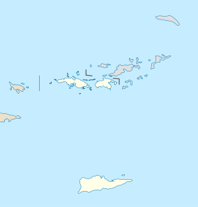 STT Location in the Virgin Islands | |||||||||||
| Runways | |||||||||||
| |||||||||||
| Statistics (2015) | |||||||||||
| |||||||||||

Cyril E. King Airport (IATA: STT, ICAO: TIST, FAA LID: STT) is a public airport located two miles (3 km) west of the central business district of Charlotte Amalie on the island of St. Thomas in the United States Virgin Islands.[1] It is currently the busiest airport in the United States Virgin Islands, and one of the busiest in the eastern Caribbean, servicing 1,403,000 passengers from July 2015 until June 2016.[2] The airport also serves nearby St. John and is often used by those traveling to the British Virgin Islands.
Although passports are not required for U.S. citizens who are visiting the U.S. Virgin Islands, all passengers bound for the United States and Puerto Rico must pass through U.S. Customs and Border Protection screening before boarding their flight. Private planes can either use CBP Preclearance or arrive in the United States as an international arrival.
The airport operates one main runway, 7,000 ft × 150 ft (2,134 m × 46 m) long. The terminal operates 11 gates.
History
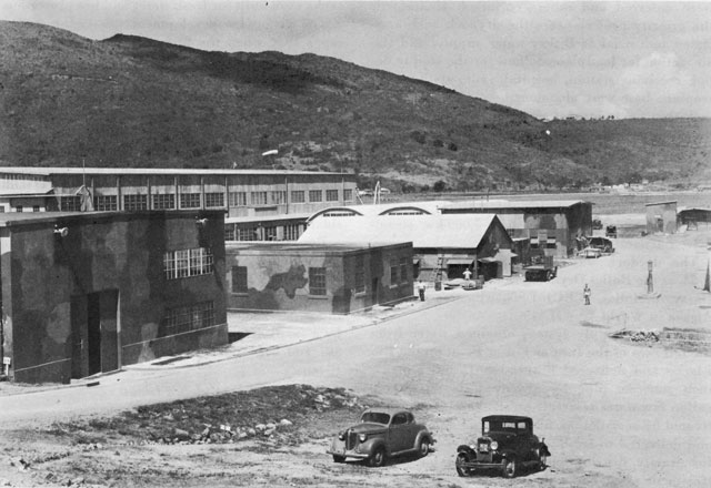
During World War II, the United States Army Air Forces Sixth Air Force 23rd Fighter Squadron (36th Fighter Group) deployed P-40 Warhawk fighters to the airport from March 1942 – May 1943.[3][4][5]
It was known as Harry S Truman Airport until 1984, when it was renamed to honor Cyril Emmanuel King, the second elected governor of the U.S. Virgin Islands. A new passenger terminal opened in November 1990 and retained the name. A renovation of the arrivals area of the terminal was completed in 2016.
Facilities and aircraft
Cyril E. King Airport covers an area of 280 acres (110 ha) which contains one asphalt paved runway (10/28) measuring 7,000 ft × 150 ft (2,134 m × 46 m). For the 12-month period ending September 30, 2015, the airport had 65,407 aircraft operations, an average of 179 per day: 58% air taxi, 14% scheduled commercial, 27% general aviation and 1% military. During the same period, there were 98 aircraft based at this airport: 59% multi-engine, 35% single engine, 3% helicopters, 2% jet engine and 1% ultralight.[1] There is also one flight school at the airport, Ace Flight Center. The St. Thomas Jet Center, on the north side of the runway, handles private aviation.
Terminal
The two story terminal has 11 gates in two departure areas. The main section serves flights bound for the United States and Puerto Rico. It contains a restaurant and bar, gift shop, and duty-free store. Three smaller departure lounges serve international and St. Croix departures.
Arriving passengers from the United States and Puerto Rico over the age of 18 are greeted with complementary samples of Cruzan Rum.
Airlines and destinations
| Airlines | Destinations |
|---|---|
| Air Sunshine | Anguilla, Dominica-Douglas–Charles, Nevis, San Juan, St. Maarten, Tortola, Virgin Gorda |
| American Airlines | Charlotte, Miami, New York-JFK Seasonal: Philadelphia |
| Cape Air | Saint Croix, San Juan Seasonal: Tortola |
| Delta Air Lines | Atlanta, Boston (begins February 18, 2017),[6] New York-JFK |
| Hummingbird Air | Dominica–Douglas–Charles, Nevis, Saint Croix, Saint Kitts |
| JetBlue Airways | Boston, San Juan |
| LIAT | Antigua, St. Maarten |
| Seaborne Airlines | Saint Croix, San Juan |
| Sea Flight Airlines | Saint Croix |
| Spirit Airlines | Fort Lauderdale |
| Sun Country Airlines | Seasonal: Minneapolis/Saint Paul |
| Tradewind Aviation | Saint Barthélemy |
| United Airlines | Seasonal: Chicago-O'Hare, Houston-Intercontinental, Newark, Washington-Dulles |
Charter Airlines
| Airlines | Destinations |
|---|---|
| Air Sunshine | Anguilla, Dominica-Melville Hall, Nevis, San Juan, Sint Maarten, Tortola, Virgin Gorda, Antigua, St. Lucia, St. Vincent, Grenada, Trinidad, Dominican Republic, Turks and Caicos, Aruba, Curaçao, Barbados and many other destinations |
Cargo Airlines
| Airlines | Destinations |
|---|---|
| Air Sunshine | Saint Maarten, San Juan, Anguilla, Nevis, Tortola, Virgin Gorda |
| Air Cargo Carriers (for UPS and DHL) | San Juan |
| Ameriflight (for UPS and DHL) | San Juan |
| Mountain Air Cargo (for FedEx) | San Juan |
Ground Transportation
Private Airport Transportation
- CaribbaConnect - Private transportation to and from St Thomas Airport
Shared Taxi Service
- VI Taxi - Virgin Islands Taxi Association
Water Taxi
Accidents and incidents
- On December 28, 1970, Trans Caribbean Airways Flight 505 operated with a Boeing 727 jetliner made a hard landing and ran off the side of the runway. Two of the 48 passengers died in the subsequent fire, and the aircraft was then destroyed by the ensuing conflagration.[7]
- On April 27, 1976, American Airlines Flight 625[8] operated with a Boeing 727 jetliner ran off the end of the runway, killing 37 of the 88 on board the aircraft. Following the crash, American Airlines (AA) suspended jet service to the airport and began operating Convair 440 propliners instead for service to nearby St. Croix (STX) and San Juan (SJU) for connections to American mainline jet flights at these airports until the St. Thomas runway was extended to its present length. These CV-440[9] flights were flown by a division of AA, American Inter-Island, as an interim service until American elected to resume mainline jet aircraft operations into St. Thomas with the advent of the longer runway.[10]
- On March 25, 1977, Douglas C-53 N692A of Island Traders was damaged beyond economic repair in a heavy landing.[11]
- On September 17, 1989, Douglas DC-3 N4425N, Douglas C-47s N100SD, N4471J and N4577Z; and Douglas C-49J N28346 of Aero Virgin Islands; along with Douglas C-47A N101AP of Four Star Air Cargo; were damaged beyond economic repair by Hurricane Hugo.[12][13][14][15][16][17]
- On December 30, 2003, Douglas DC-3C N781T of Tol-Air Services was substantially damaged when the starboard undercarriage collapsed on landing after a flight that originated at San Juan, Puerto Rico.[18]
- On July 19, 2006, Douglas DC-3C N782T of Tol-Air Services ditched into the sea off Charlotte Amalie after an engine failure shortly after take-off from Cyril E. King Airport.[19] All four people on board escaped as the aircraft floated for about ten minutes before sinking.[20] The aircraft now lies in 100 feet (30 m) of water and is a dive site.[21]
- A Kestrel Convair C-131F, registration N8277Q performing a freight flight from St. Thomas (US Virgin Islands) to unknown destination with 2 crew, departed St. Thomas' runway 28 and was in the initial climb around 07:47L (11:47Z) when the tower observed smoke from the left-hand engine (P&W R-2800). The crew declared emergency reporting an engine fire and loss of hydraulics and initiated a return to St. Thomas' runway 10, where the aircraft touched down but could not slow. The airplane veered right off the runway, broke through the airport fence and came to a stop on a public road parallel to the runway (actually the airport access road). No injuries occurred, the airplane received substantial damage. The airport was closed for several hours. The FAA reported the aircraft went off the runway and received substantial damage.[22]
- On October 13, 2012, a Piper Aztec, N5553Y, departing nearby St. Croix carrying three passengers, crashed approximately eight miles south of Cyril E. King Airport. There was one survivor. After a year-long investigation, it was determined that the pilot suffered spatial disorientation, descended before he needed to and then crashed into the water.
- On June 17, 2015, an American Airlines Boeing 757 preparing to fly to John F. Kennedy International Airport was grounded due to a mechanical failure. After returning to the gate, an airport service vehicle collided with the aircraft, severely damaging one of the aircraft's jet engines. No injuries occurred.
References
![]() This article incorporates public domain material from the Air Force Historical Research Agency website http://www.afhra.af.mil/.
This article incorporates public domain material from the Air Force Historical Research Agency website http://www.afhra.af.mil/.
- 1 2 3 FAA Airport Master Record for STT (Form 5010 PDF), retrieved November 27, 2008.
- ↑ "RITA | BTS | Transtats". www.transtats.bts.gov. Retrieved 2016-09-12.
- ↑ "HyperWar: Building the Navy's Bases in World War II [Chapter 18]". Retrieved June 7, 2015.
- ↑ "Image: bases2-p10.jpg, (640 × 440 px)". ibiblio.org. Retrieved September 2, 2015.
- ↑ "Airport Hangar (demolished) - St. Thomas VI - Living New Deal". Living New Deal. Retrieved June 7, 2015.
- ↑ "New routes, flights offered in Boston service expansion". Delta Air Lines Inc. Retrieved 15 August 2016.
- ↑ http://www.airliners.net/photo/Trans-Caribbean-Airways/Boeing-727-2A7/0153357/&sid=5cdb96e62b278558790f768d2a776ca1, photos of destroyed Trans Caribbean Airways Boeing 727-200 at St. Thomas
- ↑ http://lessonslearned.faa.gov/ll_main.cfm?TabID=1&LLID=68
- ↑ http://www.jetphotos.net/photo/8141174
- ↑ http://www.airliners.net/search/photo.search?airlinesearch==American%20Inter-Island&distinct_entry=true, photos of American Inter-Island Convair 440 aircraft at St. Thomas operating local flights to STX and SJU
- ↑ "N692A Accident description". Aviation Safety Network. Retrieved August 4, 2010.
- ↑ "N4425N Hull-loss description". Aviation Safety Network. Retrieved July 27, 2010.
- ↑ "N100SD Hull-loss description". Aviation Safety Network. Retrieved July 27, 2010.
- ↑ "N4471J Hull-loss description". Aviation Safety Network. Retrieved July 27, 2010.
- ↑ "N4577Z Hull-loss description". Aviation Safety Network. Retrieved July 27, 2010.
- ↑ "N28346 Hull-loss description". Aviation Safety Network. Retrieved July 27, 2010.
- ↑ "N101AP Hull-loss description". Aviation Safety Network. Retrieved July 27, 2010.
- ↑ "N781T Accident description". Aviation Safety Network. Retrieved June 21, 2001.
- ↑ "N782T Accident description". Aviation Safety Network. Retrieved June 21, 2010.
- ↑ "MIA06LA125". National Transportation Safety Board. Retrieved June 22, 2010.
- ↑ "Jul 2006 Gooney bird becomes latest dive site". Blue Island Divers. Retrieved June 22, 2010.
- ↑ http://avherald.com/h?article=436593dd&opt=0
External links
| Wikimedia Commons has media related to Cyril E. King Airport. |
- Virgin Islands Port Authority: Airport Facilities, official site
- Pictures of the Cyril E. King Airport
- Old Saint Thomas Airport Terminal
- Virgin Islands: Old airport hangar in St. Thomas, dating from 1939, has since been torn down and replaced with a modern passenger terminal. Photo: Larry Luxner
- photos of the Harry S Truman Airport
- aerial view of the Harry S Truman Airport
- FAA Airport Diagram (PDF), effective December 8, 2016
- FAA Terminal Procedures for STT, effective December 8, 2016
- Resources for this airport:
- FAA airport information for STT
- AirNav airport information for TIST
- ASN accident history for STT
- FlightAware airport information and live flight tracker
- NOAA/NWS latest weather observations for TIST
- SkyVector aeronautical chart for STT
- Bureau of Transportation Statictics
- St. Thomas Cyril E. King Airport from airlines.net
- St. Thomas Cyril E. King Airport from jetphotos.net
Previously: Panama Canal Air Force (1940-1941); Caribbean Air Force (1941-1942) | |||||||||||||||||||||||||
| Airfields |
| .jpg) | |||||||||||||||||||||||
| Units |
| ||||||||||||||||||||||||