Cundiff, Kentucky
| Cundiff | |
|---|---|
| Unincorporated community | |
 Cundiff  Cundiff Location within the state of Kentucky | |
| Coordinates: 36°56′41″N 85°15′16″W / 36.94472°N 85.25444°WCoordinates: 36°56′41″N 85°15′16″W / 36.94472°N 85.25444°W | |
| Country | United States |
| State | Kentucky |
| County | Adair |
| Elevation | 968 ft (295 m) |
| Time zone | Central (CST) (UTC-6) |
| • Summer (DST) | CDT (UTC-5) |
| GNIS feature ID | 507797 |
Cundiff is an unincorporated community in Adair County, Kentucky, United States. Its elevation is 968 feet (295 m).[1]
Previously known as Melson Ridge for a local hill named for the Melson family, Cundiff was likely named for Rester C. Cundiff, postmaster when the post office was opened in 1925.[2]
References
- ↑ U.S. Geological Survey Geographic Names Information System: Cundiff, Kentucky
- ↑ Rennick, Robert M. (1987). Kentucky Place Names. University Press of Kentucky. p. 76. Retrieved 2013-04-28.
Municipalities and communities of Adair County, Kentucky, United States | ||
|---|---|---|
| City | 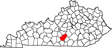 | |
| Unincorporated communities |
| |
| Footnotes | ‡This populated place also has portions in an adjacent county or counties. | |
This article is issued from Wikipedia - version of the 10/10/2016. The text is available under the Creative Commons Attribution/Share Alike but additional terms may apply for the media files.