Csongrád
| Csongrád | ||
|---|---|---|
|
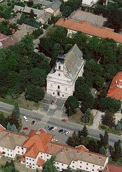
Nagyboldogasszony (Holy Virgin) Church | ||
| ||
 Csongrád | ||
| Coordinates: 46°42′40.64″N 20°8′25.01″E / 46.7112889°N 20.1402806°E | ||
| Country |
| |
| Region | Dél-Alföld | |
| County | Csongrád | |
| Subregion/Micro-region | Csongrádi | |
| Boroughs |
List
| |
| Government[1] | ||
| • Mayor | Tamás Bedő | |
| • Notary | Dr. László Juhász | |
| Area[2] | ||
| • Total | 183.683 km2 (70.920 sq mi) | |
| • Csongrád | 9.65 km2 (3.73 sq mi) | |
| • Csongrád-Bokros | 0.083 km2 (0.032 sq mi) | |
| Elevation | 83 m (272 ft) | |
| Population (2009)[3] | ||
| • Total | 17,686 | |
| • Density | 107.61/km2 (278.7/sq mi) | |
| Ethnic groups[4] | ||
| • Hungarian | 18653 | |
| • Gypsy | 89 | |
| • German | 19 | |
| • Ukrainian | 8 | |
| • Others | 18 | |
| Time zone | CET (UTC+1) | |
| • Summer (DST) | CEST (UTC+2) | |
| Postal code | 6640 | |
| Area code(s) | 63 | |
| Website | http://www.csongrad.hu/ | |
Csongrád (Romanian: Ciongrad; Serbian: Чонград/Čongrad, archaically also Црноград/Crnograd) is a town in Csongrád County in southern Hungary.


History
At the time of the Hungarian Conquest (the end of 9th century) the Maros Valley was under Bulgarian control. The fortress was known as Chorniy Grad (Slavic term for 'black castle') and served as a Bulgarian-Slavic guard outpost.[5] Later King Stephen (1000–1038) made the town a state administration center, giving its name to a county. It remained a county seat till the Mongol invasion of Hungary (1240–42). The town and fortress were badly damaged by the Mongols; king Béla IV subsequently transferred the county seat to Szeged in 1247. The move significantly affected Csongrád's recovery. It did not become a town again until 1920.[6]
Main sights
The Main Square obtained its definitive shape in the first half of the 10th century, its streets are wide with many trees. The Main Street is lined by old plane trees.
The road running along the grammar school in Secessionist style leads to the old town. This part of the settlement, called Öregvár (meaning Old Castle), preserves the structure of a Hungarian fishing-village of the 18th century. The adobes and houses with puddle wall have thatched roofs, many of them are equipped inside with modern furniture. One building can be seen with original furniture (at Gyökér utca 1).
The Tisza has a sand-bank which looks like a seashore.
Another attraction of Csongrád is the backwater generated by the river control works (Holt-Tisza), which houses several water-birds. In the wood strip on the left bank of the Tisza are the uncovered ruins of a Benedictine monastery founded in the 11th century.
Tourism
Csongrád is a small and very pretty town especially at the summer time when there are lot to see and do. This town is very quiet and peaceful, people are very hospitable and friendly. As the town is small you can get everywhere on foot or if you prefer you can ride a bike, you can cycle through Csongrád on the special bicycle lane.
The greatest attraction in Csongrád is the Tisza river bank. The river has a sandy beach and during summer hundreds of people come to bathe in the water. Csongrád has spas and some swimming pools as well, both indoor and outdoor.[7]
Csongrád's museums include:
- Csongrád's traditional style house
- László Tari Museum [8]
- István Széchenyi Elementary School's collection of the region
- Gallery of Csongrád
- Művésztelep (Artists' park)
The permanent exhibition of the museum located in the center of the city awaits the visitors by presenting a material of town history. Less than hundred meters away from here the City Gallery can be found, where from time to time periodical exhibition of the Gallery the aquarelles of the painter-artist of Csongrád, János Piroska representing the brilliant technique of color-runout as light as air are shown.[9]
There are several beautiful churches in Csongrád that are worthy of a visit:
- The Nagyboldogasszony (Holy Virgin) Church - situated in the main town square and built between 1762–69
- Saint Rókus-church
- Piroskavárosi Saint Joseph Church Franciscan Abbey[10]
There are two main festivals in the summer time:
- Csongrád Wine Festival,[11] which is usually last for 3–4 days
- Körös-Toroki Days[12] which lasts for a week
Famous residents
- Miloš Crnjanski, Serbian writer
- Geca Kon, Serbian publisher
- Pál Maléter
- János Piroska, painter
International relations
Twin towns — Sister cities
Csongrád is twinned with:
References
- István Sebestyén (1996): A Glance at Csongrád. Csongrád a vizek és a parkok városa. Raszter Kft. Kiadó, Csongrád, Hungary
Sources
- ↑ Csongrád város honlapja: Tisztségviselők (Hungarian)
- ↑ Csongrád város honlapja: Csongrád történelme (Hungarian)
- ↑ Népszámlálás 2001: 4.1.1 A népesség számának alakulása, terület, népsűrűség, 1870–2001 KSH, 2001. (Hungarian)
- ↑ Népszámlálás 2001: A nemzetiségi népesség száma. KSH, 2001. (Hungarian)
- ↑ András Róna-Tas (1999). Hungarians and Europe in the early Middle Ages: an introduction to early Hungarian history. Central European University Press. p. 266. ISBN 978-963-9116-48-1.
- ↑ Steve Fallon; Neal Bedford (2003). Hungary. Lonely Planet. pp. 303–304. ISBN 978-1-74059-152-2.
- ↑ Csongrád town's official website
- ↑ László Tari Museum
- ↑ Csongrád town official website
- ↑ List of churches in Csongrád
- ↑ Csongrád town Events Calendar
- ↑ Körös-Torok
- ↑ "Portal Bełchatów" [Bełchatów - Partnership Cities]. Miasto Bełchatów [Bełchatów town council] belchatow.pl (in Polish). 2010. Archived from the original on 13 June 2011. Retrieved 22 June 2011.
External links
- Csongrád town official website (Hungarian)
- Körös-Torok (Hungarian)
- List of churches in Csongrád (Hungarian)
- László Tari Museum (Hungarian)
- Csongrád town Events Calendar (Hungarian)
- Csongrád at funiq.hu (English)
County seat: Szeged | ||
| Cities and towns |  | |
| Villages |
| |
| Other topics |
| |
Coordinates: 46°42′41″N 20°08′25″E / 46.71129°N 20.14028°E
| Wikimedia Commons has media related to Csongrád. |