Crookes Valley Park

Crookes Valley Park is an area of public parkland in the Crookesmoor area of the City of Sheffield in South Yorkshire, England. The park lies just under two kilometres west of the City centre at 53°23′00″N 1°29′34″W / 53.3834°N 1.4929°W. It is one of the three “Crookesmoor Parks” the other two being Weston Park and The Ponderosa.
History
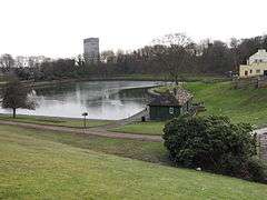
Crookes Valley Park covers an area of approximately 4.8 hectares (11.9 acres), the majority of the park is taken up by the lake which was originally a water supply reservoir called the Old Great Dam. It was one of ten reservoirs built in open countryside in the valley between Crookes and Upperthorpe to supply water to the growing City of Sheffield in the 18th century. The Old Great Dam was built in 1785 with a capacity of 21 million imperial gallons (95,000 m3) and was thought big enough to supply the town for many years, however the ten reservoirs became obsolete by the 20th century and were all filled in with the exception of the Old Great Dam.[1]
The Old Great Dam was integrated into Crookes Valley Park when it was set out by Sheffield Corporation in the early years of the 20th century. For many years it was used as a boating lake and is still used for fishing, it is fed by a small stream which flows through a culvert into the western corner. The lake is said to be 60 feet (18 m) deep and there are unsubstantiated stories of large Pike and Zander living in the depths. On the south western fringe of the park is the Dam House bar and restaurant, a building of some antiquity. It was built in the 1780s when the Dam was being constructed and originally served as the house of the Water Board’s solicitor.[2]
Two Bowling greens were constructed in the park shortly after it was opened, a children's playground was built in the 1970s. Both were constructed in a part of the park which was known as the recreation ground, and thus marked on old Ordnance Survey maps, it was an area of quite steep banking built as a dam wall for the reservoir.[3]
References
- ↑ Information board at park Gives information on history of park.
- ↑ Friends of Crookesmoor Parks. Gives history of park and dams.
- ↑ "Old Ordnance Survey Maps: Sheffield (West)" ISBN 0-85054-048-8 Gives history and topography of Old Great Dam.
Coordinates: 53°23′00″N 1°29′34″W / 53.3834°N 1.4929°W