Shire Brook Valley Local Nature Reserve
Coordinates: 53°21′11″N 1°22′12″W / 53.353°N 1.370°W The Shire Brook Valley Local Nature Reserve is located in Sheffield, England. The Local Nature Reserve was designated in 1999[1][2] and extends over an area of approximately 100 hectares. It is based around the former site of the Coisley Hill Sewage Works which closed in the early 1990s. The managers office has been converted into a visitors centre. The reserve includes Beighton Marsh, an area of reed-grass swamp, situated at its eastern end, which supports birds such as Reed Bunting, Grasshopper Warbler and Barn Owl, as well as mammals such as the Harvest Mouse and Water Vole. The Birley Spa Bath House, a grade II listed building was restored with a Heritage Lottery Fund grant in 2001. Also within the reserve is Wickfield Plantation, one of the few remaining areas of lowland heath and coppiced oak woodland inside Sheffield. The Reserve contain Carr Forge Dam which is fed by the stream which comes down from Birley Spa and is a valuable location for wildlife. New ponds were created in the same area in 1993 to mark the centenary of the City of Sheffield. The Centenary Ponds were opened by Clive Betts on 18 June 1993.

Carr Forge Dam
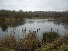
Carr Forge Dam is a dam located in the centre of the reserve. The dam dates back to the Tudor dynasty, and most of the brickwork still remains. The dam is now mainly used as a wildlife pond, with Common Toads, Common Frogs and other species including the endangered Great Crested Newt breeding in the marshes.
Shirebrook Heritage Group
The Shirebrook Heritage Group established in 1999 maintain the Valley and its visitor's centre. They run a Park Ranger Program and hold regular meetings within the Birley Spa bath house and the visitor's centre itself.
See also
References
- ↑ "Shire Brook Valley". Local Nature Reserves. Natural England. Retrieved 25 July 2013.
- ↑ "Map of Shire Brook Valley". Local Nature Reserves. Natural England. Retrieved 25 July 2013.