Criel Mound
|
South Charleston Mound | |
|
The Criel Mound | |
  | |
| Location | US 60 (MacCorkle Avenue), in city park, South Charleston, West Virginia |
|---|---|
| Coordinates | 38°22′7″N 81°41′48″W / 38.36861°N 81.69667°WCoordinates: 38°22′7″N 81°41′48″W / 38.36861°N 81.69667°W |
| Area | 1.5 acres (0.61 ha) |
| NRHP Reference # | 70000655[1] |
| Added to NRHP | October 15, 1970 |
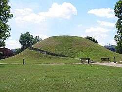
The Criel Mound is a Native American burial mound located in South Charleston, West Virginia, USA. The mound was built by the Adena culture, probably around 250–150 BC, and lay equidistant between two “sacred circles”, earthwork enclosures each 556 feet (169 m) in diameter. It was originally 33 feet (10 m) high and 173 feet (53 m) in diameter at the base, making it the second-largest such burial mound in the state of West Virginia. (The Grave Creek Mound in Moundsville is the largest.) The Criel Mound is located at 38°22′8.0″N 81°41′48.2″W / 38.368889°N 81.696722°W. This archaeological site is listed on the National Register of Historic Places.
History
The mound was originally conical in shape. Residents of the area leveled the top in 1840 to erect a judges' stand, as they ran horse races around the base of the mound at the time.
The Criel Mound was excavated in 1883–84 under the auspices of the US Bureau of Ethnology and the supervision of Col. P.W. Norris. The excavation was performed by Professor Cyrus Thomas of the Smithsonian Institution. Inside the mound, Professor Thomas found thirteen skeletons: two near the top of the mound, and eleven at the base. The skeletons at the base consisted of a single very large but badly decayed skeleton at the center, a "once most powerful man" which according to A.R. Sines who assisted Col. Norris in the excavation, measured "Six feet, 8 3–4 inches" (205 cm) from head to heel with broad shoulders, massive teeth and a very thick low and flat skull encased in a large copper headband.[2][3] This skeleton was surrounded by ten other skeletons arranged in a spoke-like pattern, with their feet pointing toward the central skeleton. The skeletons at the base had been wrapped in elm bark and were lying on a floor of white ash and bark. Several artifacts were found buried with the skeletons, including arrowheads, lanceheads, and shell and pottery fragments. The central skeleton was accompanied by a fish-dart, a lance-head, and a sheet of hammered native copper near the head. Holes found at the base of the mound suggest that the bodies at the base had been enclosed in a wooden vault.[4]
The Criel Mound is part of the second-largest known concentration of Adena mounds and circular enclosures. This area extends for eight miles (13 km) along the upper terraces of the Kanawha River floodplain, in the vicinity of present-day Charleston. In 1894, Cyrus Thomas reported 50 mounds in this area, ranging from 3’ to 35’ in height and from 35’ to 200’ in diameter. He also reported finding eight to ten circular earthworks, enclosing from 1 to 30 acres (120,000 m2). Stone mounds dotted the bluffs above the floodplain.
While many of the original Adena mounds were destroyed during later development of the area, a few remain. The Wilson Mound is in a private cemetery in South Charleston. The Shawnee Reservation Mound still exists in Institute, West Virginia.
Today, the Criel Mound is the centerpiece of Staunton Park, a small municipal park maintained by the city of South Charleston. It is a gathering place for community activities, such as arts and crafts fairs, revivals, memorial services, sunrise services, and town carnivals.
See also
Notes
- ↑ National Park Service (2009-03-13). "National Register Information System". National Register of Historic Places. National Park Service.
- ↑ Charleston Gazette, Charleston West Virginia. "Capital City of Indian Kingdom Once Stood on Site of What Is Now Charleston, Capitol of Independent State. Sunday, November 14, 1926 Pg 29".
- ↑ "National Park Service National Register of Historic Places Inventory – Nomination Form (Form 10–30 July 1969) South Charleston Mound – Criel or Creel Mound" (PDF). United States Department of The Interior National Park Service.
- ↑ South Charleston History Book Publications Committee. The History of South Charleston. 392 pages. Privately printed: 1995.
Further reading
- Dragoo, Don W. Mounds for the Dead. 315 pages. The Carnegie Museum of Natural History: 1963. ISBN 0-911239-09-X.
- Silverberg, Robert. The Mound Builders. 276 pages. Ohio University Press: 1970. ISBN 0-8214-0839-9.
- Thomas, Cyrus “Report on Mound Explorations of the Bureau of Ethnology”; In: Powell, J.W. (1894), Twelfth Annual Report of the Bureau of Ethnology to the Secretary of the Smithsonian Institution, 1890–’91; Washington: Government Printing Office, pp 416–417.
- Webb, Willam S., and Snow, Charles E. The Adena People. 369 pages. The University of Tennessee Press: 1974. ISBN 0-87049-568-2.
- Woodward, Susan L., and McDonald, Jerry N. Indian Mounds of the Middle Ohio Valley. 130 pages. McDonald and Woodward Publishing Co.: 1986. ISBN 0-939923-00-9.
External links
- Criel Mound
- The Kanawha Valley and its Prehistoric People
- Mounds & Mound Builders
- The South Charleston Museum
| Ohio sites |
|  |
|---|---|---|
| Kentucky sites |
| |
| West Virginia sites | ||
| Indiana sites | ||
| Topics |  | |
|---|---|---|
| Lists by county |
| |
| Other lists | ||
| ||