Cowan, Tennessee
| Cowan, Tennessee | |
|---|---|
| City | |
|
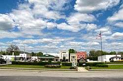
Businesses along Tennessee Avenue | |
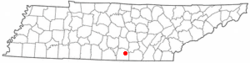 Location of Cowan, Tennessee | |
| Coordinates: 35°10′0″N 86°0′43″W / 35.16667°N 86.01194°WCoordinates: 35°10′0″N 86°0′43″W / 35.16667°N 86.01194°W | |
| Country | United States |
| State | Tennessee |
| County | Franklin |
| Area | |
| • Total | 2.0 sq mi (5.1 km2) |
| • Land | 2.0 sq mi (5.1 km2) |
| • Water | 0.0 sq mi (0.0 km2) |
| Elevation | 974 ft (297 m) |
| Population (2010) | |
| • Total | 1,737 |
| • Density | 895.6/sq mi (345.8/km2) |
| Time zone | Central (CST) (UTC-6) |
| • Summer (DST) | CDT (UTC-5) |
| ZIP code | 37318 |
| Area code(s) | 931 |
| FIPS code | 47-17700[1] |
| GNIS feature ID | 1306151[2] |
Cowan is a city in Franklin County, Tennessee, United States. The population was 1,737 at the 2010 census. It is part of the Tullahoma, Tennessee Micropolitan Statistical Area.
History
The earliest settlers arrived in the Cowan area in the late 18th and early 19th centuries. The home of one such settler, William Russell, served as the Franklin County Courthouse until the establishment of Winchester in 1810.[3] The town was named for Dr. James Benjamin Cowan,[4] a Civil War-era doctor whose family had lived in the area since the early 1800s.[5]
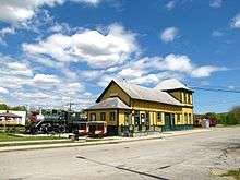
The town of Cowan dates from the mid-19th century and developed mostly as a railroad town. It was the site where several branch lines met the main Nashville to Chattanooga trunk of the Nashville, Chattanooga and St. Louis Railway which ran through the important Cowan Tunnel. As the last stop before the uphill climb onto the nearby Cumberland Plateau, pusher engines to assist trains in making the steep ascent were based there, and are still in use today.[3]
The town's economy declined with the importance of the railroad after United States Highway 41A was built in the 1940s. The old passenger depot, built in 1904,[6] was restored as a museum, and is a focal point of the downtown area.
Geography
Cowan is located at 35°10′0″N 86°0′43″W / 35.16667°N 86.01194°W (35.166668, -86.011839).[7] The city is situated at the western base of the Cumberland Plateau, and is concentrated around the point where U.S. Route 41A crosses the CSX railroad tracks. The edge of the Plateau juts out in a series of ridges creating several small valleys in the area, including Hawkins Cove to the northeast and Keith Cove to the south. Cowan is drained by Boiling Fork Creek, a tributary of the Elk River.
US 41A (Cumberland Street) is the primary road in Cowan, connecting the city with Winchester and the Tims Ford Lake area to the west. To the east of Cowan, US 41A ascends nearly 1,000 feet (300 m) to the top of the Cumberland Plateau, where it passes through Sewanee and Monteagle.[8]
According to the United States Census Bureau, the city has a total area of 2.0 square miles (5.2 km2), all land.
Demographics
| Historical population | |||
|---|---|---|---|
| Census | Pop. | %± | |
| 1880 | 222 | — | |
| 1890 | 624 | 181.1% | |
| 1930 | 1,367 | — | |
| 1940 | 1,461 | 6.9% | |
| 1950 | 1,835 | 25.6% | |
| 1960 | 1,979 | 7.8% | |
| 1970 | 1,772 | −10.5% | |
| 1980 | 1,790 | 1.0% | |
| 1990 | 1,738 | −2.9% | |
| 2000 | 1,770 | 1.8% | |
| 2010 | 1,737 | −1.9% | |
| Est. 2015 | 1,704 | [9] | −1.9% |
| Sources:[10][11] | |||
As of the census[1] of 2000, there were 1,770 people, 746 households, and 499 families residing in the city. The population density was 895.6 people per square mile (345.2/km²). There were 803 housing units at an average density of 406.3 per square mile (156.6/km²). The racial makeup of the city was 87.68% White, 9.44% African American, 0.17% Native American, 0.00% Asian, 0.79% from other races, and 1.92% from two or more races. Hispanic or Latino of any race were 1.36% of the population.

There were 746 households out of which 30.8% had children under the age of 18 living with them, 46.6% were married couples living together, 16.4% had a female householder with no husband present, and 33.0% were non-families. 31.4% of all households were made up of individuals and 14.3% had someone living alone who was 65 years of age or older. The average household size was 2.36 and the average family size was 2.95.
In the city the population was spread out with 24.7% under the age of 18, 8.5% from 18 to 24, 25.6% from 25 to 44, 22.7% from 45 to 64, and 18.5% who were 65 years of age or older. The median age was 39 years. For every 100 females there were 86.3 males. For every 100 females age 18 and over, there were 84.2 males.
The median income for a household in the city was $27,448, and the median income for a family was $33,882. Males had a median income of $27,321 versus $20,909 for females. The per capita income for the city was $18,352. About 13.4% of families and 16.7% of the population were below the poverty line, including 22.8% of those under the age of 18 and 11.4% of those 65 and older.
References
- 1 2 "American FactFinder". United States Census Bureau. Archived from the original on September 11, 2013. Retrieved 2008-01-31.
- ↑ "US Board on Geographic Names". United States Geological Survey. 2007-10-25. Retrieved 2008-01-31.
- 1 2 John Abernathy Smith, "Franklin County," Tennessee Encyclopedia of History and Culture. Retrieved: 24 April 2016.
- ↑ Larry Miller, Tennessee Place Names (Indiana University Press, 2001), p. 53.
- ↑ Jenny Lou and Jim Brock, "The Cowans of Franklin County," Cowan Railroad Museum website. Originally published in the Cowan Bell, 19 June 1975. Retrieved: 24 April 2016.
- ↑ "History," Cowan Railroad Museum website. Retrieved: 24 April 2016.
- ↑ "US Gazetteer files: 2010, 2000, and 1990". United States Census Bureau. 2011-02-12. Retrieved 2011-04-23.
- ↑ "Sewanee, Tennessee". Geographic Names Information System. United States Geological Survey.
- ↑ "Annual Estimates of the Resident Population for Incorporated Places: April 1, 2010 to July 1, 2015". Retrieved July 2, 2016.
- ↑ "Census of Population and Housing: Decennial Censuses". United States Census Bureau. Retrieved 2012-03-04.
- ↑ "Incorporated Places and Minor Civil Divisions Datasets: Subcounty Resident Population Estimates: April 1, 2010 to July 1, 2012". Population Estimates. U.S. Census Bureau. Archived from the original on June 17, 2013. Retrieved 11 December 2013.
External links
| Wikimedia Commons has media related to Cowan, Tennessee. |
| Wikivoyage has a travel guide for Cowan. |
- Visit Cowan - Cowan Commercial Club website
- Cowan Railroad Museum
- NC&StL Preservation Society
- City charter
Municipalities and communities of Franklin County, Tennessee, United States | ||
|---|---|---|
| Cities | ||
| Towns | ||
| CDP | ||
| Unincorporated communities | ||
| Ghost town | ||
| Footnotes | ‡This populated place also has portions in an adjacent county or counties | |