Corning, Arkansas
| Corning, Arkansas | |
|---|---|
| City | |
 Location in Clay County and the state of Arkansas | |
| Coordinates: 36°24′36″N 90°35′22″W / 36.41000°N 90.58944°WCoordinates: 36°24′36″N 90°35′22″W / 36.41000°N 90.58944°W | |
| Country | United States |
| State | Arkansas |
| County | Clay |
| Government | |
| • Type | mayor-council government |
| • Mayor | Rob Young |
| Area | |
| • Total | 3.1428 sq mi (8.14 km2) |
| • Land | 3.119705 sq mi (8.08 km2) |
| • Water | 0.02702715 sq mi (0.07 km2) |
| Elevation | 289 ft (88 m) |
| Population (2010) | |
| • Total | 3,377 |
| • Density | 1,082.5/sq mi (418.0/km2) |
| Time zone | Central (CST) (UTC-6) |
| • Summer (DST) | CDT (UTC-5) |
| ZIP code | 72422 |
| Area code(s) | 870 |
| FIPS code | 05-15460 |
| GNIS feature ID | 0076678 |
| Website |
www |
Corning is a city in Clay County, Arkansas, United States. The population was 3,377 at the 2010 census.[1] It is one of the two county seats of Clay County, along with Piggott.[2]
Geography
Corning is located in western Clay County at 36°24′36″N 90°35′22″W / 36.41000°N 90.58944°W (36.410057, -90.589364),[3] 2 miles (3 km) west of the Black River. U.S. Route 62 passes through the city, leading east 25 miles (40 km) to Piggott and southwest 26 miles (42 km) to Pocahontas. U.S. Route 67 leads north out of town 29 miles (47 km) to Poplar Bluff, Missouri, and joins US 62 heading southwest out of Corning to Pocahontas.
According to the United States Census Bureau, Corning has a total area of 3.14 square miles (8.14 km2), of which 3.12 square miles (8.08 km2) is land and 0.03 square miles (0.07 km2), or 0.81%, is water.[1]
History
The original settlement was about one mile east and was called Hecht City, named for brothers Levi and Solomon Hecht who operated a lumber mill on the Black River. Hecht City moved to the present site of Corning in 1871, when the Cairo and Fulton Railroad surveyed the land for the proposed route. The railroad through the settlement was completed by 1872. On February 5, 1873, the name was changed from Hecht City to Corning, in honor of H. D. Corning, an engineer with the railroad.[4]
The city of Corning went through a massive period of growth in the early part of the 20th century. In the 1960s and 1970s it was the site of many industrial manufacturing developments.
Corning was the site of a large explosion on Wednesday, March 9, 1966. The pre-dawn explosion originated in a munitions railcar and fortunately resulted in only one minor injury in the small town. The explosion was widely reported in the surrounding region.[5]
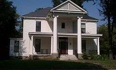
Two properties in Corning are list on the National Register of Historic Places: Sheeks House, and Oliver House.
Education
Public education for elementary and secondary students is provided by the Corning School District. Corning High School is a member of the Arkansas Activities Association. Programs include Art, Band, Spanish, Computer Tech, and Family and Consumer Sciences, along with the other basic classes that public schools provide.
Corning has always prided itself on its high school sports programs. Currently the school has boys' football, track, basketball, golf, baseball, and trap shooting. Girls' programs include, basketball, softball, track, and golf. The high school football program was once a place of dominance, having gone undefeated in 2007 and making it to the 2nd round of the state playoffs. Also successful was the varsity girls' basketball team, having made an appearance in the state Division 3A playoffs in 2009, 2010, and 2011.
Demographics
| Historical population | |||
|---|---|---|---|
| Census | Pop. | %± | |
| 1880 | 393 | — | |
| 1890 | 584 | 48.6% | |
| 1900 | 1,041 | 78.3% | |
| 1910 | 1,439 | 38.2% | |
| 1920 | 1,564 | 8.7% | |
| 1930 | 1,550 | −0.9% | |
| 1940 | 1,619 | 4.5% | |
| 1950 | 2,045 | 26.3% | |
| 1960 | 2,192 | 7.2% | |
| 1970 | 2,705 | 23.4% | |
| 1980 | 3,650 | 34.9% | |
| 1990 | 3,323 | −9.0% | |
| 2000 | 3,679 | 10.7% | |
| 2010 | 3,377 | −8.2% | |
| Est. 2015 | 3,162 | [6] | −6.4% |
2014 Estimate[8] | |||
As of the census[9] of 2000, there were 3,679 people, 1,553 households, and 1,018 families residing in the city. The population density was 1,150.0 people per square mile (443.9/km²). There were 1,722 housing units at an average density of 538.2 per square mile (207.8/km²). The racial makeup of the city was 97.77% White, 0.33% Black or African American, 0.60% Native American, 0.24% Asian, 0.11% from other races, and 0.95% from two or more races. 0.38% of the population were Hispanic or Latino of any race.
There were 1,553 households out of which 27.9% had children under the age of 18 living with them, 51.6% were married couples living together, 10.5% had a female householder with no husband present, and 34.4% were non-families. 30.7% of all households were made up of individuals and 18.2% had someone living alone who was 65 years of age or older. The average household size was 2.32 and the average family size was 2.88.
In the city the population was spread out with 23.3% under the age of 18, 8.9% from 18 to 24, 25.9% from 25 to 44, 22.0% from 45 to 64, and 19.9% who were 65 years of age or older. The median age was 39 years. For every 100 females there were 88.8 males. For every 100 females age 18 and over, there were 82.5 males.
The median income for a household in the city was $21,200, and the median income for a family was $29,485. Males had a median income of $22,095 versus $16,383 for females. The per capita income for the city was $12,953. About 18.9% of families and 23.2% of the population were below the poverty line, including 29.0% of those under age 18 and 29.6% of those age 65 or over.
Agriculture
Industry in Corning is dominated by agriculture-related industries such as farm equipment sales, farm equipment repair, seed processing and sales, and fertilizer and chemicals. Forestry was a primary industry in the late 1800s, but gave way to farming of rice, soybeans, hard red winter wheat, and other grains.
Notable people
- B. Louis Decker, Department of Defense Geodesist. Principle developer of Department of Defense World Geodetic System 1984 (WGS-84).
- Blake Johnson, Republican member of the Arkansas State Senate; rice and soybean farmer in Corning
- Jack Ladyman, Republican member of the Arkansas House of Representatives from Jonesboro; former Corning resident
- W. Stephen Smith, voice teacher and author, Northwestern University Professor of Voice and Opera
Climate
The climate in this area is characterized by hot, humid summers and generally mild to cool winters. According to the Köppen Climate Classification system, Corning has a humid subtropical climate, abbreviated "Cfa" on climate maps.[10]
References
- 1 2 "Geographic Identifiers: 2010 Demographic Profile Data (G001): Corning city, Arkansas". U.S. Census Bureau, American Factfinder. Retrieved June 16, 2014.
- ↑ "Find a County". National Association of Counties. Archived from the original on 2011-05-31. Retrieved 2011-06-07.
- ↑ "US Gazetteer files: 2010, 2000, and 1990". United States Census Bureau. 2011-02-12. Retrieved 2011-04-23.
- ↑ Webb, Robert T. (1933). History and Traditions of Clay County. Mountain Home, AR: Shiras Bros.
- ↑ "Only 1 Hurt In Blast Of Munitions Train". Palm Beach Post. 3/9/1966. Retrieved 1 September 2012. Check date values in:
|date=(help) - ↑ "Annual Estimates of the Resident Population for Incorporated Places: April 1, 2010 to July 1, 2015". Retrieved July 2, 2016.
- ↑ "Census of Population and Housing". Census.gov. Archived from the original on May 11, 2015. Retrieved June 4, 2015.
- ↑ "Annual Estimates of the Resident Population for Incorporated Places: April 1, 2010 to July 1, 2014". Retrieved June 4, 2015.
- ↑ "American FactFinder". United States Census Bureau. Archived from the original on 2013-09-11. Retrieved 2008-01-31.
- ↑ Climate Summary for Corning, Arkansas
External links
- City of Corning official website
- Encyclopedia of Arkansas History & Culture entry: Corning (Clay County)
Municipalities and communities of Clay County, Arkansas, United States | ||
|---|---|---|
| Cities |  | |
| Towns | ||
| Unincorporated communities | ||
| Ghost town | ||