Cookville, Texas
| Cookville | |
|---|---|
| Unincorporated community | |
 Cookville  Cookville Location within the state of Texas | |
| Coordinates: 33°11′8″N 94°51′16″W / 33.18556°N 94.85444°WCoordinates: 33°11′8″N 94°51′16″W / 33.18556°N 94.85444°W | |
| Country | United States |
| State | Texas |
| County | Titus |
| Elevation | 433 ft (132 m) |
| Time zone | Central (CST) (UTC-6) |
| • Summer (DST) | CDT (UTC-5) |
| ZIP codes | 75558 |
| GNIS feature ID | 1333275 |
Cookville is an unincorporated community in eastern Titus County, Texas, United States. It lies along U.S. Route 67 east of the city of Mount Pleasant, the county seat of Titus County.[1] Its elevation is 433 feet (132 m).[2] Although Cookville is unincorporated, it has a post office, with the ZIP code of 75558, located at the junction of US 67 and Farm to Market Road 1000.[3]
References
- ↑ Rand McNally. The Road Atlas '08. Chicago: Rand McNally, 2008, p. 100.
- ↑ U.S. Geological Survey Geographic Names Information System: Cookville, Texas
- ↑ Zip Code Lookup
External links
Municipalities and communities of Titus County, Texas, United States | ||
|---|---|---|
| Cities | 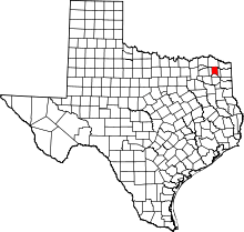 | |
| Town | ||
| Unincorporated communities | ||
This article is issued from Wikipedia - version of the 7/30/2016. The text is available under the Creative Commons Attribution/Share Alike but additional terms may apply for the media files.