Colorado State Highway 391
| ||||
|---|---|---|---|---|
|
Map of Jefferson County in north central Colorado with SH 391 highlighted in red | ||||
| Route information | ||||
| Maintained by CDOT | ||||
| Length: | 9.51 mi[1] (15.30 km) | |||
| Major junctions | ||||
| South end: |
| |||
| North end: |
| |||
| Location | ||||
| Counties: | Jefferson | |||
| Highway system | ||||
|
Colorado State Highways
| ||||

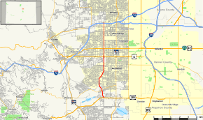
State Highway 391 is a 9.51-mile (15.30 km) long north–south state highway in the vicinity of Denver, Colorado.
Route description
The southern terminus of the route is at U.S. Highway 285 in Lakewood. The northern terminus is at Interstate 70 exit 267 in Wheat Ridge. The road is known as Kipling Parkway from US 285 north to West Mississippi Avenue and Kipling Street from Mississippi to I-70.
History
The route was established in 1955, when it began at Colfax Avenue and headed south to Alameda Avenue. The northern terminus was extended to 44th Avenue by 1967 and to Interstate 70 by 1968. SH 391 was extended south to U.S. Highway 285 in 1985.[2]
Major intersections
The entire route is in Jefferson County.
| Location | mi[1][3] | km | Destinations | Notes | |
|---|---|---|---|---|---|
| Lakewood | 0.0 | 0.0 | Southern terminus; road continues south as Kipling Street | ||
| 1.0 | 1.6 | ||||
| 5.1 | 8.2 | ||||
| 6.3 | 10.1 | ||||
| Wheat Ridge | 9.3 | 15.0 | Northern terminus, exit 267 on I-70 | ||
| 1.000 mi = 1.609 km; 1.000 km = 0.621 mi | |||||
References
- 1 2 "Segment list for SH 391". Retrieved 2007-05-12.
- ↑ Salek, Matthew E. "Colorado Routes 367-399". Retrieved 2010-05-29.
- ↑ Google (January 2, 2014). "Colorado State Highway 391" (Map). Google Maps. Google. Retrieved January 2, 2014.
External links
This article is issued from Wikipedia - version of the 11/20/2015. The text is available under the Creative Commons Attribution/Share Alike but additional terms may apply for the media files.