Coleman, Georgia
| Coleman, Georgia | |
|---|---|
| City | |
|
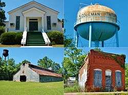
Coleman in 2012. | |
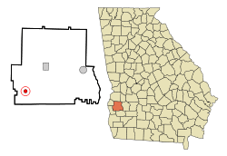 Location in Randolph County and the state of Georgia | |
| Coordinates: 31°40′22″N 84°53′25″W / 31.67278°N 84.89028°WCoordinates: 31°40′22″N 84°53′25″W / 31.67278°N 84.89028°W | |
| Country | United States |
| State | Georgia |
| County | Randolph |
| Area | |
| • Total | 0.8 sq mi (2 km2) |
| • Land | 0.8 sq mi (2 km2) |
| • Water | 0 sq mi (0 km2) |
| Elevation | 400 ft (122 m) |
| Population (2000) | |
| • Total | 149 |
| • Density | 186.3/sq mi (74.5/km2) |
| Time zone | Eastern (EST) (UTC-5) |
| • Summer (DST) | EDT (UTC-4) |
| ZIP codes | 31736, 39836 |
| Area code(s) | 229 |
| FIPS code | 13-17580[1] |
| GNIS feature ID | 0312820[2] |
Coleman was a city in Randolph County, Georgia. The population was 149 at the 2000 census. The city was abolished by House Bill 1102 effective January 1, 2007, and no longer exists as a municipality.
Geography
Coleman is located at 31°40′22″N 84°53′25″W / 31.67278°N 84.89028°W (31.672794, -84.890269).[3]
According to the United States Census Bureau, the city has a total area of 0.8 square miles (2.1 km2), of which, 0.8 square miles (2.1 km2) of it is land and 1.30% is water.
Demographics
| Historical population | |||
|---|---|---|---|
| Census | Pop. | %± | |
| 1890 | 211 | — | |
| 1900 | 263 | 24.6% | |
| 1910 | 354 | 34.6% | |
| 1920 | 342 | −3.4% | |
| 1930 | 400 | 17.0% | |
| 1940 | 270 | −32.5% | |
| 1950 | 295 | 9.3% | |
| 1960 | 220 | −25.4% | |
| 1970 | 168 | −23.6% | |
| 1980 | 164 | −2.4% | |
| 1990 | 137 | −16.5% | |
| 2000 | 149 | 8.8% | |
As of the census[1] of 2000, there were 149 people, 66 households, and 34 families residing in the city. The population density was 194.4 people per square mile (74.7/km²). There were 84 housing units at an average density of 109.6 per square mile (42.1/km²). The racial makeup of the city was 38.26% White and 61.74% African American.
There were 66 households out of which 19.7% had children under the age of 18 living with them, 36.4% were married couples living together, 13.6% had a female householder with no husband present, and 47.0% were non-families. 43.9% of all households were made up of individuals and 15.2% had someone living alone who was 65 years of age or older. The average household size was 2.26 and the average family size was 3.26.
In the city the population was spread out with 25.5% under the age of 18, 4.0% from 18 to 24, 31.5% from 25 to 44, 24.8% from 45 to 64, and 14.1% who were 65 years of age or older. The median age was 37 years. For every 100 females there were 93.5 males. For every 100 females age 18 and over, there were 91.4 males.
The median income for a household in the city was $24,583, and the median income for a family was $30,938. Males had a median income of $22,750 versus $18,958 for females. The per capita income for the city was $13,279. There were 24.3% of families and 32.0% of the population living below the poverty line, including 41.2% of under eighteens and 53.3% of those over 64.
Gallery
-

Coleman Town Hall
-
.JPG)
Coleman Post Office (ZIP code: 39836)
-

Coleman Volunteer Fire Department
References
- 1 2 "American FactFinder". United States Census Bureau. Archived from the original on 2013-09-11. Retrieved 2008-01-31.
- ↑ "US Board on Geographic Names". United States Geological Survey. 2007-10-25. Retrieved 2008-01-31.
- ↑ "US Gazetteer files: 2010, 2000, and 1990". United States Census Bureau. 2011-02-12. Retrieved 2011-04-23.
- ↑ "Census of Population and Housing". Census.gov. Archived from the original on May 11, 2015. Retrieved June 4, 2015.
Municipalities and communities of Randolph County, Georgia, United States | ||
|---|---|---|
| Cities | 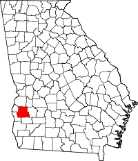 | |
| CDP | ||