Cold Bay Airport
| Cold Bay Airport | |||||||||||||||
|---|---|---|---|---|---|---|---|---|---|---|---|---|---|---|---|
 | |||||||||||||||
|
IATA: CDB – ICAO: PACD – FAA LID: CDB – WMO: 70316 | |||||||||||||||
| Summary | |||||||||||||||
| Airport type | Public | ||||||||||||||
| Owner | State of Alaska DOT&PF - Central Region | ||||||||||||||
| Serves | Cold Bay, Alaska | ||||||||||||||
| Hub for | PenAir | ||||||||||||||
| Elevation AMSL | 101 ft / 31 m | ||||||||||||||
| Coordinates | 55°12′19″N 162°43′28″W / 55.20528°N 162.72444°WCoordinates: 55°12′19″N 162°43′28″W / 55.20528°N 162.72444°W | ||||||||||||||
| Map | |||||||||||||||
 CDB Location of airport in Alaska | |||||||||||||||
| Runways | |||||||||||||||
| |||||||||||||||
| Statistics (2011) | |||||||||||||||
| |||||||||||||||

Cold Bay Airport (IATA: CDB, ICAO: PACD, FAA LID: CDB) is a state owned, public use airport located in Cold Bay,[1] a city in the Aleutians East Borough of the U.S. state of Alaska. First built as a United States Army Air Forces airfield during World War II, it is one of the main airports serving the Alaska Peninsula. Scheduled passenger service is available and air taxi operators fly in and out of the airport daily. Formerly, the airport operated as Thornbrough Air Force Base.
According to Federal Aviation Administration (FAA) records, the airport had 9,105 passenger boardings (enplanements) in calendar year 2008,[2] 8,968 enplanements in 2009, and 9,261 in 2010.[3] It is included in the National Plan of Integrated Airport Systems for 2011–2015, which categorized it as a "non-primary commercial service" airport, meaning it has between 2,500 and 10,000 enplanements per year.[4]
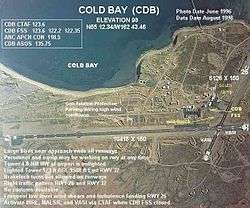
Cold Bay's main runway is the fifth-largest in Alaska and was built during World War II. Today, it is used for scheduled cargo flights by Alaska Central Express and Evergreen International Airlines and is sometimes used as an emergency diversion airport for passenger flights crossing the Pacific Ocean.[5]
A myth describes Cold Bay Airport as an alternate landing site for Space Shuttles, but the National Aeronautics and Space Administration (NASA) has stated that it was never so designated, and it was not within the entry crossrange capability of Space Shuttles.
There is a National Weather Service (NWS) office (which sends up radiosonde balloons twice a day) colocated with the FAA Flight Service Station at the airport. The NWS ranks Cold Bay as the cloudiest city in the United States.[6]
History
The airport was constructed during World War II as Fort Randall Army Airfield, eventually becoming an Air Force Base during the Cold War.
Facilities and aircraft
Cold Bay Airport has two asphalt paved runways: 14/32 is 10,180 by 150 feet (3,174 x 46 m) and 8/26 is 6,235 by 150 feet (1,900 x 46 m). For the 12-month period ending January 1, 2011, the airport had 9,210 aircraft operations, an average of 25 per day: 63% air taxi, 29% scheduled commercial, 5% military, and 2% general aviation.[1]
Airlines and destinations
The following airlines offer scheduled passenger service at this airport:
| Airlines | Destinations |
|---|---|
| PenAir | Anchorage |
Accidents and incidents
- September 8, 1973: World Airways Flight 802, a Douglas DC-8 operating on a cargo flight for the Military Airlift Command, crashed into Mount Dutton, 16 miles (26 km) east of Cold Bay, while on instrument approach to the airport. All six people on board were killed.
References
- 1 2 3 FAA Airport Master Record for CDB (Form 5010 PDF). Federal Aviation Administration. Effective April 5, 2012.
- ↑ "Passenger Boarding (Enplanement) and All-Cargo Data for U.S. Airports" (PDF, 1.0 MB). Federal Aviation Administration. December 18, 2009.
- ↑ "CY 2010 Passenger Boarding and All-Cargo Data" (PDF, 189 KB). Federal Aviation Administration. October 4, 2011.
- ↑ "2011–2015 National Plan of Integrated Airport Systems, Appendix A" (PDF). Federal Aviation Administration. October 4, 2010. Archived from the original (PDF, 2.03 MB) on 2012-09-27.
- ↑ "Continental trans-Pacific flight makes emergency landing". The Associated Press. 2004-10-19. Archived from the original on 2004-10-19.
- ↑ Osborn, Liz. "Cloudiest Places in United States". Current Results weather and science facts. Current Results Nexus. Retrieved 10 September 2015.
External links
- FAA Airport Diagram for Cold Bay (CDB) (PDF), effective November 10, 2016
- FAA Terminal Procedures for Cold Bay (CDB), effective November 10, 2016
- FAA Alaska airport diagram (GIF)
- Topographic map from USGS The National Map
- Resources for this airport:
- FAA airport information for CDB
- AirNav airport information for PACD
- ASN accident history for CDB
- FlightAware airport information and live flight tracker
- NOAA/NWS latest weather observations for PACD
- SkyVector aeronautical chart for CDB
- Military history